Kirjojen hintavertailu. Mukana 11 244 527 kirjaa ja 12 kauppaa.

Kirjahaku

Etsi kirjoja tekijän nimen, kirjan nimen tai ISBN:n perusteella.

293 kirjaa tekijältä Barbara Raue

The Life and Times of Barbara: Snapshots of My Life

The Life and Times of Barbara: Snapshots of My Life

Barbara Raue

Createspace Independent Publishing Platform
2012
nidottu
Twenty years ago I began organizing and compiling my memoirs and have about one hundred volumes put together. They were a great resource for writing my story, along with the dozens of photo albums of family pictures and outings over the years. No one is likely to read through 100 volumes, so it was time to reduce them to the size of a book. Family, genealogy, trips we have taken, history of inventions, reading and photography are some of the interests I have shared.
Entertainment That I Have Enjoyed: The Life and Times of Barbara

Entertainment That I Have Enjoyed: The Life and Times of Barbara

Barbara Raue

Createspace Independent Publishing Platform
2013
nidottu
Television was still in its infancy when I entered this world and most of the shows were in black and white. It wasn't until I was in high school that most of the programming was in full colour. I Love Lucy, Leave it to Beaver, Lone Ranger, Gunsmoke were enjoyable to watch and get involved in the entertainment. The opportunity to go to the movies was rare and therefore it was a big event during Grade 12 for a group of us to go to the theatre to see Gone With the Wind based on the novel by Margaret Mitchell which we had read earlier in the year. Hawaii Five-O, The Bionic Man and Wonder Woman were fantasies to enjoy. The movie Fiddler on the Roof has special meaning to me as it was the night I fell in love with Harry, my husband of the past 40 years. Canada's Wonderland was a great place to take our boys; Michael was the eager one to go on all the thrilling roller coasters, while Zane was a little more laid back. Harry and I had seasons' tickets for several years to Theatre Aquarius, an incentive for us to spend time together on a regular basis without the children and the everyday cares of life. Tall Ships were in Port Colborne in 2001 and Harry and I took our daughter Annette with us for a day on the waterfront. It is my belief that as life continues on I must nourish and stimulate my mind on a daily basis, always looking for ways to grow and mature. I began taking courses in 2005, beginning with Evelyn Wood's Memory Dynamics where I learned techniques for remembering details. The Seven Habits of Highly Effective People and The Eighth Habit by Steven Covey were more food for the mind. I continue to pursue my interests in history, art, geology, architecture, photography and astronomy. I joined a women's Book Club in 2006 and have had the opportunity to read several classics, such as War and Peace and Anna Karenina by Leo Tolstoy, as well as more current books. Since I had never been exposed to this type of reading, there were many ideas that I followed up with research on the internet. Sea Biscuit and Unbroken by Laura Hillenbrand and Born to Run by Christopher McDougall were enjoyable books to read and learn from.
East Coast Trips: The Life and Times of Barbara

East Coast Trips: The Life and Times of Barbara

Barbara Raue

Createspace Independent Publishing Platform
2013
nidottu
Our trip to the East Coast of Canada in June 2009 started at the Halifax Airport where Harold and Diane Miller met us to take us on a tour of Nova Scotia, Cape Breton Island on the Cabot Trail and Cape Breton Highlands National Park. We spent an enjoyable day in Baddeck, Nova Scotia to see the Alexander Graham Bell Museum and to watch an air show commemorating the 100th anniversary of flight. We travelled to Pictou where we took the ferry to Prince Edward Island, had a tour of Charlottetown, and the next day travelled the country roads to the Green Gable Shore to see the area that Lucy Maud Montgomery made famous in her book Anne of Green Gables. That evening we had tickets for Anne the Musical which we thoroughly enjoyed. We continued our journey through the quaint villages of P.E.I. to Summerside, then on to Gateway Village at the base of the Confederation Bridge which we drove across into New Brunswick for a short drive back into Nova Scotia. We had time to see some of Amherst before night closed in. In 2002 we took a trip to Newfoundland and took in some of its beauty.
Cobourg Ontario Book 1 in Colour Photos: Saving Our History One Photo at a Time
Cobourg is a town in Southern Ontario ninety-five kilometers (59 miles) east of Toronto and 62 kilometers (39 miles) east of Oshawa. It is located along Highway 401. To the south, Cobourg borders Lake Ontario.The settlements that make up today's Cobourg were founded by United Empire Loyalists in 1798. The Town was originally a group of smaller villages such as Amherst and Hardscrabble, which were later named Hamilton. In 1808 it became the district town for the Newcastle District. It was renamed Cobourg in 1818, in recognition of the marriage of Princess Charlotte Augusta of Wales to Prince Leopold of Saxe-Coburg-Saalfeld (who later become King of Belgium).By the 1830s Cobourg had become a regional center, much due to its fine harbor on Lake Ontario. In 1835 the Upper Canada Academy was established in Cobourg by Egerton Ryerson and the Wesleyan Conference of Bishops. On July 1, 1837, Cobourg was officially incorporated as a town. In 1841 the Upper Canada Academy's name was changed to Victoria College. In 1842 Victoria College was granted powers to confer degrees.Cobourg retains its small-town atmosphere, in part due to the downtown and surrounding residential area's status as a Heritage Conservation District. The downtown is a well-preserved example of a traditional small-town main street. Victoria Hall, the town hall completed in 1860, is a National Historic Site of Canada. The oldest building in the town is now open as the Sifton-Cook Heritage Centre and operated by the Cobourg Museum Foundation.Food processing is the largest industry in Cobourg, and it is home to SABIC Innovative Plastics and Weetabix.
Cobourg Ontario Book 2 in Colour Photos: Saving Our History One Photo at a Time
Cobourg is a town in Southern Ontario ninety-five kilometers (59 miles) east of Toronto and 62 kilometers (39 miles) east of Oshawa. It is located along Highway 401. To the south, Cobourg borders Lake Ontario.The settlements that make up today's Cobourg were founded by United Empire Loyalists in 1798. Settlers started arriving in Cobourg in the 179s when at the time it was known for its forty houses, two inns, four stores, several distilleries, a grist mill and about 350 people. The Town was originally a group of smaller villages such as Amherst and Hardscrabble, which were later named Hamilton. In 1808 it became the district town for the Newcastle District. It was renamed Cobourg in 1818, in recognition of the marriage of Princess Charlotte Augusta of Wales to Prince Leopold of Saxe-Coburg-Saalfeld (who later become King of Belgium).James Cockburn, born in England, moved to Montreal with his family in 1832. In 1845 he came to Cobourg to practice law and, until 1849, shared a practice with D'Arcy Boulton, another prominent politician. Married in 1854 to Isabella Susan Patterson, Cockburn began raising a family and found interest in public affairs. He was elected to the Cobourg town council in 1856, 1858 and 1859. During this time, when plans for Victoria Hall floundered due to lack of finances, Cockburn offered the leadership which saw the project completed in 1860. While serving in local politics Cockburn acquired a reputation for honesty, fair dealing, integrity and sound logic. He was one of the Fathers of Confederation.Cobourg retains its small-town atmosphere, in part due to the downtown and surrounding residential area's status as a Heritage Conservation District.
Cobourg Ontario Book 3 in Colour Photos: Saving Our History One Photo at a Time
Cobourg is a town in Southern Ontario ninety-five kilometers (59 miles) east of Toronto and 62 kilometers (39 miles) east of Oshawa. It is located along Highway 401. To the south, Cobourg borders Lake Ontario.The settlements that make up today's Cobourg were founded by United Empire Loyalists in 1798. The Town was originally a group of smaller villages such as Amherst and Hardscrabble, which were later named Hamilton. In 1808 it became the district town for the Newcastle District. It was renamed Cobourg in 1818, in recognition of the marriage of Princess Charlotte Augusta of Wales to Prince Leopold of Saxe-Coburg-Saalfeld (who later become King of Belgium).By the 1830s Cobourg had become a regional center, much due to its fine harbor on Lake Ontario. In 1835 the Upper Canada Academy was established in Cobourg by Egerton Ryerson and the Wesleyan Conference of Bishops. On July 1, 1837, Cobourg was officially incorporated as a town. In 1841 the Upper Canada Academy's name was changed to Victoria College. In 1842 Victoria College was granted powers to confer degrees.Cobourg retains its small-town atmosphere, in part due to the downtown and surrounding residential area's status as a Heritage Conservation District. The downtown is a well-preserved example of a traditional small-town main street. Victoria Hall, the town hall completed in 1860, is a National Historic Site of Canada. The oldest building in the town is now open as the Sifton-Cook Heritage Centre and operated by the Cobourg Museum Foundation.
Cobourg Ontario Book 4 in Colour Photos: Saving Our History One Photo at a Time
Cobourg is a town in Southern Ontario ninety-five kilometers (59 miles) east of Toronto and 62 kilometers (39 miles) east of Oshawa. It is located along Highway 401. To the south, Cobourg borders Lake Ontario.The settlements that make up today's Cobourg were founded by United Empire Loyalists in 1798. The Town was originally a group of smaller villages such as Amherst and Hardscrabble, which were later named Hamilton. In 1808 it became the district town for the Newcastle District. It was renamed Cobourg in 1818, in recognition of the marriage of Princess Charlotte Augusta of Wales to Prince Leopold of Saxe-Coburg-Saalfeld (who later become King of Belgium).By the 1830s Cobourg had become a regional center, much due to its fine harbor on Lake Ontario.Cobourg retains its small-town atmosphere, in part due to the downtown and surrounding residential area's status as a Heritage Conservation District.The downtown is a well-preserved example of a traditional small-town main street. Victoria Hall, the town hall completed in 1860, is a National Historic Site of Canada. The oldest building in the town is now open as the Sifton-Cook Heritage Centre and operated by the Cobourg Museum Foundation.
Cobourg Ontario Book 5 in Colour Photos: Saving Our History One Photo at a Time
Cobourg is a town in Southern Ontario ninety-five kilometers (59 miles) east of Toronto and 62 kilometers (39 miles) east of Oshawa. It is located along Highway 401. To the south, Cobourg borders Lake Ontario.The settlements that make up today's Cobourg were founded by United Empire Loyalists in 1798. The Town was originally a group of smaller villages such as Amherst and Hardscrabble, which were later named Hamilton. In 1808 it became the district town for the Newcastle District. It was renamed Cobourg in 1818, in recognition of the marriage of Princess Charlotte Augusta of Wales to Prince Leopold of Saxe-Coburg-Saalfeld (who later become King of Belgium).By the 1830s Cobourg had become a regional center, much due to its fine harbor on Lake Ontario. In 1835 the Upper Canada Academy was established in Cobourg by Egerton Ryerson and the Wesleyan Conference of Bishops. On July 1, 1837, Cobourg was officially incorporated as a town. In 1841 the Upper Canada Academy's name was changed to Victoria College. In 1842 Victoria College was granted powers to confer degrees.Cobourg retains its small-town atmosphere, in part due to the downtown and surrounding residential area's status as a Heritage Conservation District. The downtown is a well-preserved example of a traditional small-town main street. Victoria Hall, the town hall completed in 1860, is a National Historic Site of Canada. The oldest building in the town is now open as the Sifton-Cook Heritage Centre and operated by the Cobourg Museum Foundation.
Sampler Book 10, Ontario in Colour Photos: Saving Our History One Photo at a Time
Each photo I take that precedes a demolition, or a natural disaster such as a tornado or a fire, is meeting this aim of mine of Saving Our History One Photo at a Time. There are more than 100 towns already photographed which you can visit without moving from your comfortable chair in your living room. Think about what it was like in those by-gone days. Imagine what it was like to live in a mansion like one of these.Sampler Book 10 includes pictures from the following places in Ontario: Grimsby, St. Catharines, Smithville, the Town of Lincoln, and the Town of Pelham.
Belfountain and Inglewood Ontario in Colour Photos: Saving Our History One Photo at a Time
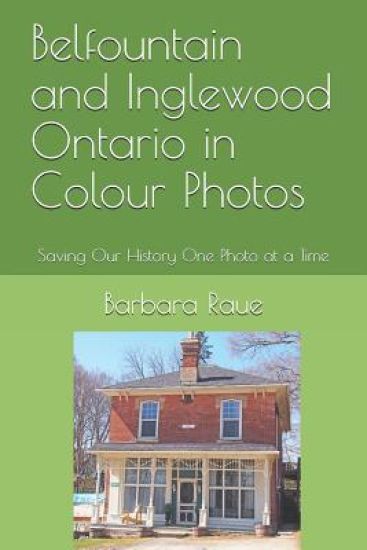
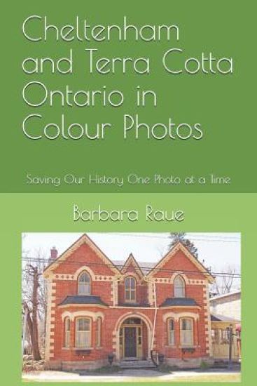
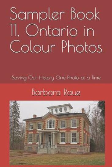
Caledon is a town in the Regional Municipality of Peel in the Greater Toronto Area. Caledon remains primarily rural. It consists of an amalgamation of a number of urban areas, villages, and hamlets; its major urban centre is Bolton on its eastern side adjacent to York Region.Caledon is one of three municipalities of Peel Region. The town is just northwest of the city of Brampton. In 1973 Caledon acquired more territory when Chinguacousy dissolved with most sections north of Mayfield Road (excluding Snelgrove) transferred to the township.Some of the smaller communities in the town include: Alton, Belfountain, Boston Mills, Caledon, Caledon Village, Campbell's Cross, Cheltenham, Inglewood, Mono Mills, Sandhill, Terra Cotta, and Victoria. The region is very sparsely populated with farms.By 1869, Belfountain was a picturesque village in the Township of Caledon County Peel on the Forks of the Credit Road on the Credit River. There were stagecoaches to Erin and Georgetown.After the survey of Caledon Township was completed in 1819, pioneers such as the Grahams, McColls, McCannells, Martins, Whites and McGregors settled in the area around present day Inglewood. They cleared the land, sharing common problems and interests.In 1843, on the nearby Credit River, Thomas Corbett built a dam and dug a mill race to provide water power to run the Riverdale Woolen Mill. David Graham became a partner in the mill in 1860, and after a fire, reconstructed it in stone in 1871. By this time, Graham was Corbett's son-in-law. The mill attracted potential employees and their families to the area. Early settlers discovered deposits of sandstone and dolomite nearby on the Niagara Escarpment. Joachim Hagerman opened a quarry in 1875, the first of many.The Hamilton & Northwestern Railway arrived in 1877 and was crossed over by the Credit Valley Railway in 1878. The railways provided cheap and easily accessible transportation, for both locally quarried stone and manufactured goods of the woolen mill. A general store and railway hotel were soon built.The village housing built in this period, much of it by Graham, reflected the Ontario Cottage form popular in that Victorian era. Most houses were built using local lumber from the William Thompson Planing Mill, a more affordable option than brick. These cottages usually featured a front verandah, a center door symmetrically flanked by windows and a steep roof line with a front center gable surrounding a Gothic or arched window, the basic elements of the Victorian Gothic style. In Inglewood, most homes were left unadorned, a style referred to locally as Rural or Carpenter's Gothic.The increase in population gave rise to many small industries, and from the mid-1880s until 1910, Inglewood's commercial growth included several general stores, a blacksmith, a livery and wagon maker's shop, a butcher shop, a bakery, a general hardware and tinsmith business, a barber shop, glove factory, post office, library, and a branch office of the Northern Crown Bank.
Cheltenham and Terra Cotta Ontario in Colour Photos: Saving Our History One Photo at a Time
Cheltenham - In 1816 Charles and Martha Haines and three children left England for New York; the following year they arrived in York, Upper Canada, where Charles, a millwright, built mills. In 1819, the Chinguacousy Township survey was completed and Haines purchased 100 acres along the Credit River with a mill site west of Creditview Road. The Haines family settled in what he named 'Cheltenham' after his birthplace. It is located north-west of Brampton.In 1827 he built a grist mill, dammed the river and chiseled mill stones. In 1842, Frederick Haines, the second son, built Cheltenham's first store. In 1845, the first tavern was built and run by C. Spence. In 1847, to meet demand, Haines built a larger mill with three runs of stone, and he constructed a saw mill on the south side of the river. In 1848, William Henry built an Inn. In 1850, the first blacksmith shop was built. In 1852, Cheltenham post office opened with William Allan as first postmaster. By 1853, Cheltenham had three hotels. In the 1860s, the commercial core expanded with the addition of four shoe stores, a saddlery, and two cabinet makers. In 1874, the Hamilton & Northwestern Railway arrived north of the village (later became CNR). In 1877, the Credit Valley Railway arrived about one kilometer east of the village, accessed by Station Road. In the 1870s, Kee's steam tannery was started and two distilleries produced 'Cheltenham Wheat Whisky'. In 1887, fire destroyed a major block of buildings; rebuilding began. In 1914, Interprovincial Brick Company opened a plant just west of the village center.In 1822, Joseph Kenny was awarded a Crown Grant in Chinguacousy Township of 100 acres along the Credit River on which much of Terra Cotta now sits. It is located south of Cheltenham. In 1857, Henry Tucker purchased 40 acres from Kenny to build grist and saw mills powered by a dam and mill race on the Credit River. Simon Plewes bought the mills in 1859 and the hamlet became known as Plewes Mills.By the time a church, the Wesleyan Methodist Church, was built in 1862 the village had been renamed Salmonville for the annual spawning frenzy. A post office opened in 1866 and by 1874 there were thirty-four surveyed lots in the hamlet on the banks of the Credit River.This early community spread westwards and straddled the boundary of Chinguacousy and Esquesing townships. This divided the village schoolchildren, their two schoolhouses being in opposite directions. By 1873 the village had acquired telegraph facilities, two sawmills and a grist mill, and in 1877 the Hamilton & Northwestern Railway arrived, stimulating local industry and farm exports.Industry began with brickworks exploiting the local red clay, and by 1891 the post office was renamed Terra Cotta. In the 1930s, the brickworks became victims of the Depression and only a kiln chimney remains. Quarries east of Terra Cotta were established in the 1840s and the arrival of the railway broadened their market reach, allowing local sandstone to be used as far away as Ottawa in the Parliament Buildings. In the 1940s, community enterprise expanded into recreation. The river's abundant water resources were used to develop Clancy's Ranch as a weekend resort, expanded in 1949 into Terra Cotta Playground, and purchased in 1958 by Credit Valley Conservation
Sampler Book 11, Ontario in Colour Photos: Saving Our History One Photo at a Time
Each photo I take that precedes a demolition, or a natural disaster such as a tornado or a fire, is meeting this aim of mine of Saving Our History One Photo at a Time. There are more than 100 towns already photographed which you can visit without moving from your comfortable chair in your living room. Think about what it was like in those by-gone days. Imagine what it was like to live in a mansion like one of these.Sampler Book 11 includes pictures from the following places in Durham Region, Ontario: Whitby, Ajax, Pickering, Oshawa, Uxbridge, and Port Perry.
London Ontario in Photos: Saving Our History One Photo at a Time

London Ontario in Photos: Saving Our History One Photo at a Time

Barbara Raue

Createspace Independent Publishing Platform
2012
nidottu
London, Ontario is the subject of Book 1 in the Cruising Ontario series of books of photographs of towns and cities in Ontario. The photos show the architecture and design of old buildings, many that are over 100 years old. Sometimes there are descriptions of the buildings and some background information, but mostly it is a visual experience to enjoy.
Oakville Ontario in Photos: Saving Our History One Photo at a Time

Oakville Ontario in Photos: Saving Our History One Photo at a Time

Barbara Raue

Createspace Independent Publishing Platform
2012
nidottu
Oakville, Ontario is the subject of Book 4 in the Cruising Ontario series of books of photographs of towns and cities in Ontario. The photos show the architecture and design of old buildings, many that are over 100 years old. Sometimes there are descriptions of the buildings and some background information, but mostly it is a visual experience to enjoy. Barbara's sister has lived in Oakville for many years.
Chesley Ontario in Photos: Saving Our History One Photo at a Time

Chesley Ontario in Photos: Saving Our History One Photo at a Time

Barbara Raue

Createspace Independent Publishing Platform
2012
nidottu
Sconeville was the name of the settlement that developed here following the erection of mills on the Saugeen River by Adam Elliot in 1858-1859. A post office, named after Solomon Chesley, a former Indian Department official, was established in 1865 and the village took on the name of Chesley. A branch of the Grand Trunk Railway was completed to Chesley in 1881 facilitating its development as a centre for agricultural businesses and the shipment of produce, livestock, lumber and bark.Chesley is located in Bruce County on Sideroad 30 North; it is north of Walkerton on Bruce Road 19, and north of Hanover on County Road 10.
Owen Sound Ontario in Photos: Saving Our History One Photo at a Time

Owen Sound Ontario in Photos: Saving Our History One Photo at a Time

Barbara Raue

Createspace Independent Publishing Platform
2012
nidottu
Owen Sound, Ontario is the subject of Book 8 in the Cruising Ontario series of books of photographs of towns and cities in Ontario. The photos show the architecture and design of old buildings, many that are over 100 years old. Sometimes there are descriptions of the buildings and some background information, but mostly it is a visual experience to enjoy. Owen Sound is a town where we have spent many hours wandering its streets, relaxing in the parks, visiting the waterfalls, and soaking in the sunshine at the beach.