Kirjojen hintavertailu. Mukana 11 627 220 kirjaa ja 12 kauppaa.

Kirjahaku

Etsi kirjoja tekijän nimen, kirjan nimen tai ISBN:n perusteella.

25 kirjaa tekijältä David Brawn

Ibiza Tour and Trail Map

Ibiza Tour and Trail Map

David Brawn

Discovery Walking Guides Ltd
2016
kartta, viikattu
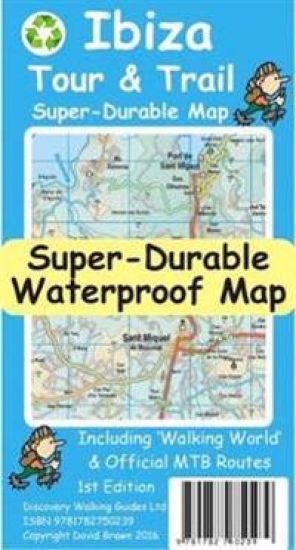
For better adventures, use the best map. Water-proof, split-proof, tear-proof, adventure-proof. Ibiza Tour & Trail Super-Durable Map is simply the toughest, most accurate, easy to read, easy to use map of the island you can buy at any price. David & Ros Brawn have partnered with Walking World to include the highlighted routes for 39 detailed walking routes on the island, plus the 20 Official mountain bike cycling routes are also highlighted on their detailed routes. Large, 40k scale, easy to read map sheets include a wealth of useful details. 20 metre and 100 metre contours combined with altitude shading bring these impressive Ibiza landscapes to life. All of the legendary Tour & Trail attention to detail is included so that you will find those petrol stations, mirador viewpoints with parking, refreshment stops with parking and accurate road numbering that are so essential when adventuring by hire car. 'Off-Tarmac' Ibiza Tour & Trail Map is in a league of its own thanks to all those Walking World hiking trails (39) and the official mountain biking routes (20). Being such a large 40k scale map means that Ibiza covers both sides of the 840mm by 600mm super-durable map sheet with a generous 5.6 kilometre common overlap between the East and West map sheets, while still folding back to a pocketable 235mm by 120mm when folded. 'Super-Durable' means a waterproof, tear-proof, map that can take the roughest treatment and still folds up like new after your adventures. Printed on Polyart using specialist 100% oxygenation inks produces a lightweight map that feels like silk but is a tough as old boots as it shrugs off water, resists tearing and damage better than any other map. 'Super-Durable' combined with our special concertina map fold means this 'near indestructible' Tour & Trail Map unfolds easily for use, and more importantly folds back up easily to its compact pocket size even after the toughest use. Digital editions are available from Discovery Walking Guides website.
Sierra de Aracena Tour & Trail Map

Sierra de Aracena Tour & Trail Map

David Brawn

Discovery Walking Guides Ltd
2016
kartta, viikattu
1:40,000 scale topographical map covering the Sierra de Aracena region in northern Huelva/Andalucia. All walking routes from Sierra de Aracena - a Walk! Guidebook; are clearly highlighted. Discover the hidden Spain of western Andalucia which is a delight for leisure walkers who appreciate the natural world and 1st class culinary delights; the Jabugo pata negra ham and local setas make for a unique dining experience. 2nd edition includes 1 minute Lat/Long grid, road and development updates and specially highlighted walking trails. Produced to Tour & Trail standards resulting in a map of outstanding accuracy and clarity. Whether you are driving, walking, hiking, horse riding or mountain biking this is the map to carry with you. Digital editions of Tour & Trail Maps for phone apps and Garmin users are available on the dwgwalking website.
Costa del Sol (Axarquia) Tour and Trail Map

Costa del Sol (Axarquia) Tour and Trail Map

David Brawn

Discovery Walking Guides Ltd
2017
kartta
For better adventures, use the best map. Costa del Sol (Axarquia) Tour & Trail Super-Durable Map comes with a 2 year adventurous use wear and tear guarantee against splitting or falling apart, see Discovery Walking Guides website for details. Custom Map digital editions for gps phone apps and Garmin users are available from the Discovery Walking Guides website. Our large 1:40,000 scale, combined with splitting the region into West and East sections with a generous overlap, produces double sided map whose total size is 840mm by 700mm that folds to a pocketable 240mm by 120mm. Costa del Sol (Axarquia) covers the region from Ventas de Zafarraya in the North-West to Almunecar in the South-East; approx 3 42'W to 4 08'W and 36 43'N to 36 58'N. You get the most detailed map of the region that is produced including our 'Tour & Trail' level of detail ranging from major roads to secondary roads to minor roads to streets and narrow rural country roads, plus dirt roads and walking trails. Altitude background colouring is designed to clearly show the altitude range when travelling across the region by car or on foot. 100 metre and 50 metre contours are clearly shown on the map along with a large number of individual height points. Tour & Trail attention to detail is legendary as is our useful symbol range including miradors, picnic areas, petrol stations, bar/restaurants and parking areas where you can pull off the road safely. You will easily identify springs, caves, quarrys, sports grounds, cemeterys, churchs, chapels, lighthouses, towers and forts, camping areas, wind turbines, hotels and golf courses. For adventurers on foot Tour & Trail Maps are researched and designed by hikers for use by hikers. Our comprehensive gps ground surveys produce the best road mapping available but the value of this on the ground research becomes even more important when you leave the tarmac. All of our DWG walking routes are accurately gps surveyed giving you confidence in the accuracy of our Tour & Trail Maps. Costa del Sol (Axarquia) Tour & Trail Super-Durable Map includes all the walking routes from Walk! the Costa del Sol (Axarquia) which are specially highlighted (red outline) while the official GR (Gran Recorido) long distance trails are also specially highlighted (green outline) along with other local hiking routes. It all adds up to the most detailed, most durable, most useful map of the Costa del Sol (Axarquia) that you can buy anywhere. Super-Durable Maps are printed with 100% oxygenation inks on Polyart by the UK's leading map printer, which produces a map that feels like silk but will stand up to the roughest treatment of outdoor adventuring and yet fold up like new at the end of your adventure. 'Special Concertina Map Fold' makes Tour & Trail Maps easy to use, and more importantly easy to fold back to their handy pocket size. Polyart is made of high-density polyethylene (HDPE) and is therefore 100% recyclable in category 2 HDPE. For more information see the Polyart website.
Costa Blanca Mountains Tour and Trail Map

Costa Blanca Mountains Tour and Trail Map

David Brawn

Discovery Walking Guides Ltd
2018
kartta
For better adventures, use the best map. Costa Blanca Mountains Tour & Trail Super-Durable Map 2nd edition is the essential map for everyone looking to explore the exciting mountainous hinterland of the Costa Blanca. Whether you are exploring on foot, bike or horse this is your first choice map. Scale 1:40,000 2.5cms = 1km. Double-sided 780mm by 600mm folded to 21cm by 12cm. For the 2nd edition we have carried out a thorough makeover while also adding a large number of walking tracks and trails. Walk! the Costa Blanca Mountains' 37 walking routes are highlighted in red, Official PR/GR walking routes are highlighted in green. For the 2nd edition we have added 72 walking routes from the Costa Blanca Mountain Walkers website maintained by Bob and Jean Hall, these are highlighted in blue. Our red/green/blue highlighting makes it easy to identify your walking routes on the new map. We have also checked that Costa Blanca by Landscapes 13 walking routes are correctly shown, along with 27 walking routes from Costa Blanca by Rother. All the usual details of Tour & Trail Maps are included: Roads; Motorway, major roads, secondary roads, minor roads & tarmacked lanes including latest road numbering system. Tracks & Trails; Unsurfaced (dirt) roads and walking trails. Heights; 100 & 20 metre contours, height & trig points in metres, height background colours in 200 metre colour bands. UTM 1km Grid with WGS84 Datum. The map region is divided into North and South sheets with a generous overlap, and configured so that for the continuation North-South, or South-North, you simply turn the map sheet towards, or away, from you. Super-Durable means we print this map on a special material, using special inks combined with a unique curing to give a map that is as `tough as old boots' and which will take you through the toughest adventures and still fold up like new. DWG back Super-Durable Maps with a 2 Year Adventurous Use guarantee, see our website for details. A special map concertina map fold means your map unfolds easily and more importantly folds back easily to pocket sized folded format. Tour & Trail Super-Durable Maps are fully recyclable. Digital editions of our Costa Blanca Mountains Tour & Trail Map for phone app and Garmin users are available on our Discovery Walking Guides website.
Menorca Tour and Trail Map

Menorca Tour and Trail Map

David Brawn

Discovery Walking Guides Ltd
2018
kartta, viikattu
For the best adventures, use the best map. Menorca Tour & Trail Super-Durable Map covers this beautiful island at 40k scale resulting in the most detailed and toughest map of Menorca that you can buy. Menorca is a large island (700 sq kms) resulting in a large, 840mm by 600mm, double sided map sheet with East on one side and the West on the reverse. A generous common overlap reduces the need to turn the map over when navigating. Our special `concertina map fold' makes the map easy to unfold and refold to its pocket size, 215mm by 120mm. Super-Durable Maps include a 2 year adventurous use wear and tear guarantee. At 40k scale, the level of detail we can include on Menorca Tour & Trail Super-Durable Map is awesome. Building on our previous editions, we have our legendary level of Tour & Trail detail including the named archaeological sites. New in 2018 for our 7th edition are the road widening works on the ME-1 main road across the island, 30 new Official Walking Routes and 20 Official Cycling Routes. These new routes, along with Walk! Menorca walking routes and the Cami de Cavalls, are specially highlighted on the map making them easier to find and to follow on the ground. We've checked that `Menorca Landscapes' routes are correctly shown on our map. Whichever source you use for your hiking or cycling adventures, Menorca Tour & Trail Super-Durable Map will be your map of choice. Quite simply, Menorca Tour & Trail Super-Durable Map is the toughest, most usable map of the island that you can buy. Digital editions of Tour & Trail Maps for phone apps and Garmin users are available on the dwgwalking website.
Fuerteventura Tour and Trail Map

Fuerteventura Tour and Trail Map

David Brawn

Discovery Walking Guides Ltd
2018
kartta
For the best adventures, use the best map. Fuerteventura is a large, 1,660 square kilometres, island. At 65k scale Fuerteventura Tour & Trail Super-Durable Map is a large 960mm by 620mm, double sided map sheet, which folds down to its 220mm by 120mm pocket size. A specialist concertina map fold means this map is easy to unfold for use and then refold to its pocket size. Super-Durable means that the Tour & Trail Map is printed on a plastic substrate using specially curing inks to produce a map that feels like silk but is tougher than any other map. Super-Durable is backed by a Discovery Walking Guides (DWG) 2-Year Guarantee against failure in the adventurous use for which the map is designed. If your Super-Durable Map gets dirty then gently wipe clean with a soft wet cloth and allow to fully dry before refolding to pocket size. On one side of the map is the island's north with the south on the reverse side. There's a generous common overlap to minimise turning the map in use. 100 metre contours combined with altitude shading bring these impressive landscapes to life. All the legendary Tour & Trail attention to detail is included, so that you'll find those petrol stations, mirador viewpoints with parking, refreshment stops with parking and accurate road numbering that are essential when adventuring by hire car. The recently opened motorway-style main roads bypassing Costa Calma and linking Corralejo to Puerto del Rosario are included, along with their detailed road junctions. 'Off-Tarmac' Fuerteventura Tour & Trail Map is in a league of its own thanks to all the hiking trails and dirt tracks included in our map design. The GR131 Official (155 kilometre/7 days) long distance walking trail from Faro de Jandia to Corralejo and the Isla de Lobos is specially highlighted in red. All the walking routes (30+) from Landscapes of Fuerteventura plus routes (40+) from Fuerteventura-Hiking are specially highlighted in green. All of the highlighted walking routes are backed up by detailed gps survey records. Whichever walking adventures you choose, you'll find them on our Fuerteventura Tour & Trail Super-Durable Map. See Amelia Bolger's You Tube 3 Stunning Walks in Fuerteventura to see the island landscapes. Digital editions for phone apps and Garmin users are available on the Discovery Walking Guides website. See You Tube 3 Stunning Walks in Fuerteventura.
Yorkshire 3 Peaks Challenge Map

Yorkshire 3 Peaks Challenge Map

David Brawn

Discovery Walking Guides Ltd
2019
kartta
Yorkshire 3 Peaks Challenge Map at 25k scale with challenge routes highlighted. OS 50k scale mapping is doubled in size to produce a 25k map but the features, text and logos are now doubled in size making them much easier to read under challenge conditions. Y3P 12 Hour Challenge Route, and its options for ascending Whernside, are added and specially highlighted so that the route stands out against the OS background map. Then we add any additional detail you might need including the popular Challenge starting points of the Pen Y Ghent Cafe, Station Inn and Hill Inn. On the reverse of the map sheet are the Challenge and OS Legends, cover design, and an access map (approx 60k scale) for road access from the nearest towns of Ingleton and Settle. The result is a double sided 600mm by 600mm OSlike Super-Durable Map. We then print the map design on a 100 micron plastic substrate using a special UV curing inks process on the UK's only press capable of using this latest technology. The result is a lightweight map that is both waterproof and tearproof, and fully recyclable, that will survive anything your 3 Peaks Challenge can throw at it and afterwards will fold up like new.
National 3 Peaks Challenge Maps

National 3 Peaks Challenge Maps

David Brawn

Discovery Walking Guides Ltd
2019
kartta
National 3 Peaks Challenge Maps. Ben Nevis, Scafell Pike and Snowdon at 20k scale. Waterproof, tearproof and 100% recyclable 820mm by 420mm double sided map sheet. Taking OS mapping at 50k scale we expand the mapping to produce 20k scale maps of the three challenge peaks, Ben Nevis, Scafell Pike and Snowdon. By expanding the OS mapping the features of names, roads, tracks and trails are more than doubled in size making them easier to read under Challenge conditions. We then add the Challenge Routes, specially highlighted to make them stand out against the OS map background information and add in additional information that will help your challenge. Each map covers the region to show the access roads as well as the walking routes. Ben Nevis includes the Glen Nevis Information Centre starting point and Glen Nevis Youth Hostel starting point. Scafell Pike includes the Wasdale and Seathwaite Challenge Routes. Snowdon includes the Pyg Track, Miners Track and Llamberis Challenge Routes. Each peak is a 420mm by 420mm OSlike map mounted on a double sided map sheet of 840mm by 420mm. The map designs are then printed on a 100 micron plastic substrate using UV cured inks on the UK's only press capable of using this latest technology. The result is a lightweight map that is both waterproof and tearproof, and fully recyclable, that will survive anything your 3 Peaks Challenge can throw at it and afterwards will fold up like new.
Tenerife Hikers Maps

Tenerife Hikers Maps

David Brawn

Discovery Walking Guides Ltd
2019
kartta, viikattu
For the best adventures, use the best map. Our latest hiking research on Tenerife has resulted in new editions of Walk! Tenerife and Tenerife Hikers' Super-Durable Maps. Thanks to Jan Kostura's research we have several new hiking adventures described in detail in Walk! Tenerife. Jan's gps records of his research for new routes and updating of current routes has provided the detailed information to produce our new fourth edition of Tenerife Hiker's Super-Durable Maps.Note that Tenerife Hikers' Super-Durable Maps is a collection of four 30k scale map sections on a double sided sheet of 840mm by 600mm which folds up to 220mm by 120mm. It is not a map of all of Tenerife. You will find 30k scale maps covering Valle de Orotava, West, Anaga and Adeje/Arona - Teide printed on a double sided map sheet. We have combined two previous maps into a single map section; El Portillo and Valle de Orotava (and all the area between) is now a single map section covering the Orotava Valley from Aguamansa to beyond El Portillo and it also includes 4 new walking routes from Walk! Tenerife (2017) including the GR131 El Portillo to La Caldera, and two ascents of Montana Limon.Our 'Las Canadas-Adeje/Arona' map is now extended northwards beyond Teide so it now also includes Pico del Teide, Montana Blanca, Pico Viejo and Montana Rajada as well as the full Las Canadas crater. The 'West' map includes the latest TF-1 road along with the rerouting of three walking routes in this region. Not a lot changes in the Anaga except that Jan's research has produced three new hiking routes; Igueste - Chamorga, Igueste - Semaforo, and Cruz del Carmen - Punta del Hidalgo.Tenerife Hikers' Super-Durable Maps is produced using our 'Tour & Trail' level of detail ranging from major roads to secondary roads to minor roads to streets and camino rural narrow country roads, plus dirt roads and walking trails.Altitude background colouring is designed to clearly show the altitude range when travelling across the regions by car or on foot. 100 metre and 50 metre contours are clearly shown on the map along with a large number of individual height points and all of the official 'Trig' points. Our useful symbol range includes miradors, picnic areas, petrol stations, bar/restaurants and parking areas where you can pull off the road safely. You will easily identify springs, caves, sports grounds, cemeterys, churchs, chapels, lighthouses, towers and forts, camping areas, wind turbines, hotels and those all important information offices. Our 'Special Concertina Map Fold' makes Tour & Trail Maps easy to use, and more importantly easy to fold back to their handy pocket size.'Super-Durable' means you get a map printed on Polyart with 100% oxygenation inks by a UK leading map printer. This gives you a map that feels like silk but will stand up to the roughest treatment of outdoor adventuring and yet fold up like new at the end of your adventure. Polyart is made of high-density polyethylene (HDPE) and is therefore 100% recyclable in category 2 HDPE. For more information see the Polyart website. Digital editions of Tour & Trail Maps for phone apps and Garmin users are available on the dwgwalking website.
Isle of Wight Walkers Map

Isle of Wight Walkers Map

David Brawn

DISCOVERY WALKING GUIDES LTD
2019
kartta
Isle of Wight Walkers' Map at 32k scale with challenge routes and walking trails highlighted. OS 50k scale mapping is expanded in size to produce a 32k map. The OS features, text and logos are now 50% larger making them much easier to read under outdoor conditions.
Corfu TourTrail Super-Durable Map

Corfu TourTrail Super-Durable Map

David Brawn

DISCOVERY WALKING GUIDES LTD
2019
kartta
For better adventures, use the best map. Corfu TourTrail Super-Durable Map is the most detailed, accurate, toughest, large scale map of the island that you can buy. Our large 1:40,000 scale produces a double sided map sheet of 840mm by 680mm; big enough to show masses of detail but compact enough to use in the car or on the trail.
Coast to Coast Challenge Map

Coast to Coast Challenge Map

David Brawn

Discovery Walking Guides Ltd
2019
kartta, viikattu
The whole 'Wainwright' Coast to Coast on one double sided, 960mm by 694mm, map sheet. All 193 miles (308 kilometres) of the Wainwright route along with its alternatives are highlighted across 9 map sections at 40k scale. Ordnance Survey accuracy is combined with Tour & Trail map design to produce 40k scale map sections which are easy to read. OS 50k Landranger mapping is expanded to 40k scale making the text and features over 40% larger making them easy to read and understand. Wainwright's C2C walking routes, and their alternatives, are specially highlighted in Tour & Trail style making the routes easy to find on the map and on the ground. Public `Rights of Way' paths and bridleways are also highlighted in Tour & Trail style making them easy to recognise and find. Coast 2 Coast Challenge Map design is then printed on Polyart using 100% oxygenation inks to produce a lightweight, Super-Durable, waterproof map that is tough enough to shrug off the worst that the C2C can subject it to and still fold up like new at the end of each day. In addition to the Super-Durable printed map, Discovery Walking Guides offers you a free `C2C Digital Resources Package'. Simply follow the instructions on the map to receive a download link to the zip file, which contains all 9 map sections as digital Custom Map editions in kmz file format along with 13 gpx waypoint files covering the 13 stages of the C2C. Combining the Super-Durable Map with the Digital Resources Package gives you trouble free navigation for the whole C2C Challenge route from St Bees to Robin Hood's Bay.
La Palma Tour & Trail Map

La Palma Tour & Trail Map

David Brawn

Discovery Walking Guides Ltd
2019
kartta, viikattu
For the best adventures, use the best map. Water-proof, split-proof, tear-proof, adventure-proof. La Palma Tour & Trail Super-Durable Map 7th edition is simply the toughest, most accurate, easy to read, easy to use map of the island you can buy at any price. Super-Durable Maps come with a 2 year adventurous use `Wear and Tear' guarantee. 7th Edition of our La Palma Tour & Trail Super-Durable Map is a large 1:40,000 scale map, plus you can get digital editions from dwgwalking.co.uk . Splitting the island into a North (Landscape view) and South (Portrait view) with a generous overlap, produces a double sided map of 900mm by 700mm which folds to 235mm by 120mm. Our legendary 'Tour & Trail' level of detail ranges from major roads to secondary roads to minor roads to streets and camino rural narrow country roads, plus dirt roads and walking trails. Altitude background colouring is designed to clearly show the altitude range when travelling across the island by car or on foot. 100 metre and 50 metre contours are clearly shown on the map, along with a large number of individual height points and all of the official 'Trig' points. Tour & Trail attention to detail includes our useful symbol range including miradors, picnic areas, petrol stations, bar/restaurants and parking areas where you can pull off the road safely. You will easily identify springs, caves, sports grounds, cemeteries, churches, chapels, lighthouses, towers and forts, camping areas, wind turbines, hotels etc. For adventurers on foot Tour & Trail Maps are researched and designed by hikers for use by hikers. Our comprehensive gps ground surveys produce the best road mapping available but the value of this on the ground research becomes even more important when you leave the tarmac. All of our DWG walking routes are accurately gps surveyed, giving you confidence in the accuracy of our Tour & Trail Maps. La Palma Tour & Trail Super-Durable Map includes all the walking routes from Walk! La Palma (highlighted in red) along with the GR130 (in eight one day sections) and GR131 (in three one day sections) long distance hiking routes (highlighted in green), plus details of the PR walking routes (Pequeno Recoridos, highlighted in purple), plus details of the SL walking routes (Senderos Locales). It all adds up to the most detailed, most durable, most useful map of La Palma that you can buy anywhere. 'Super-Durable' means a waterproof, tear-proof, map that can take the roughest treatment and still folds up like new after your adventures. Our special concertina map fold means this 'near indestructible' Tour & Trail Map unfolds easily for use, and more importantly folds back up easily to its compact pocket size even after the toughest use. Digital editions of Tour & Trail Maps for phone apps and Garmin users are available on the dwgwalking website.
Edale Skyline Challenge Map

Edale Skyline Challenge Map

David Brawn

DISCOVERY WALKING GUIDES LTD
2020
kartta
Edale Skyline Challenge is the most scenic of challenge routes thanks to the ridge line nature of its route. At just over 20 miles with a 10 hour challenge time it is suitable for fit leisure walkers as a great day out in good weather; in bad weather it really is a challenge. Free digital app and gps editions included in your purchase.
Alpujarras Tour and Trail Map

Alpujarras Tour and Trail Map

David Brawn

Discovery Walking Guides Ltd
2020
kartta
For the best adventures, use the best map. The Moorish white villages of the Alpujarras are well known to day trippers from the Costa del Sol. For walkers this is an idyllic region with stone-laid donkey trails linking the tipico villages and stretching up the southern slopes of the Sierra Nevada to Mulhacen; at 3,483 metres the highest mountain peak on mainland Spain. From Spring to the end of Autumn this is a paradise for hikers, whether you are walking from village to village sampling the local delicacies or tackling the challenging major ascents. One thing you will know is that using the Alpujarras Tour & Trail Map will help you plan, and get the best out of, your adventures. On a large 960mm by 700mm, double sided, map sheet at 40k scale this map has all the detail you need including 20 and 100 metre contours, combined with altitude shading, giving you a true feel to this impressive landscape stretching from west of Lanjaron to Ohanes in the east taking in the Poqueira and Trevelez valleys, while going north to include Mulhacen and Veleta mountain peaks along with the Sierra Nevada ski area. The GR240, GR142 & GR7 (official long distance hiking routes) are specially highlighted (in green) along with all the walking routes from Walk! the Alpujarras guidebook (in red). Our new edition Alpujarras Tour & Trail Map covers an area of 70 kms (E-W) by 28 kms (N-S); more than twice the land area of our earlier editions. A special 'Concertina Map Fold' makes Tour & Trail Maps easy to use, and more importantly easy to fold back to their handy pocket size. Digital editions of Alpujarras Tour & Trail Map are available for phone apps and Garmin users on our Discovery Walking Guides website. Tour & Trail Super-Durable Maps are printed on a specially finished plastic substrate using special inks which produces a lightweight map that feels like silk while being both water-proof and incredibly tough so that after even the toughest of adventures your Tour & Trail Super-Durable Map will fold up like new. Super-Durable Maps come with a 2 year adventurous use wear and tear guarantee. All the materials used for this map are 100% recyclable in category 2 HDPE.
Madeira Tour and Trail Map

Madeira Tour and Trail Map

David Brawn

DISCOVERY WALKING GUIDES LTD
2021
kartta
For your best adventures, use the best map. Madeira's favourite map just got a whole lot better. Now in its 10th edition including the new Palheiro golf development, goodbye to the abandoned Ponta Pargo golf course, final sections of the VE3 road, loads of minor road updating especially in the south west. For hikers we have added several new highlighted walking routes. Madeira Tour & Trail Map is a large 960mm by 700mm double sided map sheet. Super-Durable edition comes with a 2 year adventurous use guarantee. Specialist concertina map folding means the 960mm by 700mm double sided map folds quickly to its 235mm by 120mm pocket size. This most detailed map of Madeira includes our 'Tour & Trail' level of detail ranging from major roads to secondary roads to minor roads to streets and camino rural narrow country roads, plus dirt roads and walking trails. Altitude background colouring is designed to clearly show the altitude range when travelling across the island by car or on foot. 100 metre and 50 metre contours are clearly shown on the map along with a large number of individual height points and all of the official 'Trig' points. Tour & Trail attention to detail is legendary as is our useful symbol range including miradors, picnic areas, petrol stations, bar/restaurants and parking areas where you can pull off the road safely. You will easily identify springs, caves, sports grounds, cemetries, churchs, chapels, lighthouses, towers and forts, camping areas, wind turbines, hotels etc. For adventurers on foot Tour & Trail Maps are researched and designed by hikers for use by hikers. Our comprehensive gps ground surveys produce the best mapping available but the value of this on the ground research becomes even more important when you leave the tarmac. All of our DWG walking routes are accurately gps surveyed giving you confidence in the accuracy of our Tour & Trail Maps. Madeira Tour & Trail Map includes all the walking routes from 'Madeira Walks' volumes 1 & 2 by Shirley Whitehead highlighted in Red while other published walking routes (printed guide books and reliable web publications) are highlighted in Green. It all adds up to the most useful map of Madeira that you can buy anywhere. In use maps have a very tough life so you will appreciate our specialist concertina map fold that allows you to quickly open the map, and more importantly fold it back up to its pocket size after use. Paper maps will always suffer from the repeated unfolding, folding to the section you want to use, and then refolding. We recommend everybody to obtain our Super-Durable editions printed with 100% oxygenation inks on Polyart by the UK's leading map printer, which produces a map that feels like silk but will stand up to the roughest treatment of outdoor adventuring and yet fold up like new at the end of your adventure. Tour & Trail Super-Durable Maps are more expensive than paper maps, but represent better value as they produce a lightweight map that feels like silk while being both water-proof and incredibly tough so that after even the toughest of adventures your Tour & Trail Super-Durable Map will fold up like new. Digital editions of Madeira Tour & Trail Map for phone apps and Garmin users are available on the dwgwalking website.
Yorkshire 3 Peaks Challenge Map and Guide

Yorkshire 3 Peaks Challenge Map and Guide

David Brawn

DISCOVERY WALKING GUIDES LTD
2022
kartta
Yorkshire 3 Peaks Challenge Map and Guide at 25k scale with challenge route specially highlighted. We licence OS 50k scale mapping which is then doubled in size to produce a 25k map but the features, text and logos are now doubled in size making them much easier to read under challenge conditions. Y3P 12 Hour Challenge Route is added and specially highlighted so that the route stands out against the OS background map. Then we add the additional detail you might need including the popular Challenge starting points of the Pen Y Ghent Cafe (Horton), Station Inn (Ribblehead) and the Hill Inn (Chapel-le-Dale). Then we add the four parts of our Challenge Guide; 1 Horton to Pen-y-ghent, 2 Pen-y-ghent to Whernside, 3 Whernside to Ingleborough, 4 Ingleborough to Horton. The gps track and 47 waypoints (highlighted on the map) of our Challenge is available as a free gpx file download, and can be used on all gps phone apps and gps units. On the reverse of the map sheet is our Locator Map using OS Opendata showing the location of, and access to, the Yorkshire 3 Peaks Challenge relative to a wide area of England. The result is a double sided 600mm by 600mm map design. We then print the map design on a 100 micron plastic substrate using a special UV curing inks process on the UK's only press capable of using this latest technology. The result is a lightweight map that is both waterproof and tearproof, and fully recyclable, that will survive anything your Yorkshire 3 Peaks Challenge can throw at it and afterwards will fold up like new.
Gran Canaria Tour and Trail Map

Gran Canaria Tour and Trail Map

David Brawn

DISCOVERY WALKING GUIDES LTD
2022
kartta, viikattu
For the best adventures, use the best map. Gran Canaria Tour & Trail Super-Durable Map (50k scale) is a large 960mm by 700mm double sided map sheet which folds to its 235mm by 120mm pocket size. A special concertina map fold makes the map easy to unfold and refold in use. Super-Durable means water-proof and tear-proof, simply wipe clean with a damp cloth if your map gets dirty. This map has a "2 Year Guarantee" covering adventurous use. Gran Canaria North is on one side with South on the reverse side, while a generous common overlap minimises your map turning. This 6th edition is the result of DWG partnering 'Rambling Roger', Isabelle and Dane, surveying Gran Canaria in detail to produce this map. 20 metre and 100 metre contours combined with altitude shading bring these impressive landscapes to life. All of the legendary Tour & Trail attention to detail is included so that you will find those petrol stations, mirador viewpoints with parking, refreshment stops with parking and accurate road numbering that are so essential when adventuring by hire car. 'Off-Tarmac' Gran Canaria Tour & Trail Map is in a league of its own thanks to all the hiking trails and dirt tracks surveyed by Roger, Isabelle and Dane. Rambling Roger's walking trails from his latest guides are highlighted in red making this map and Roger's guides perfect for your walking adventures. We have also checked the walking routes from `Landscapes of Gran Canaria' and `Rother Gran Canaria' so whichever guide book you use this is your first choice map for your adventures. While Gran Canaria Tour & Trail Super-Durable Map will give years of adventurous use all the materials used in its production are fully recycleable. Quite simply, this is the toughest, most useable map of Gran Canaria for all your hiking, biking, car touring adventures. Digital editions of our Gran Canaria Tour & Trail Map are available as in-app purchases for Outdooractive and Locus Map apps. Discovery Walking Guides offer digital editions of Gran Canaria Tour & Trail Map in kmz (Garmin), sqlite.db for apps, and Oziexplorer formats, see website dwgwalking.co.uk for details.
Madeira Tour and Trail Map paper edition

Madeira Tour and Trail Map paper edition

David Brawn

DISCOVERY WALKING GUIDES LTD
2022
kartta, viikattu
For your best adventures, use the best map. Madeiras favourite map is now in its 10th edition including the new Palheiro golf development, goodbye to the abandoned Ponta Pargo golf course, final sections of the VE3 road, loads of minor road updating especially in the south west. For hikers we have added several new highlighted walking routes. Madeira Tour and Trail Map is a large 960mm by 700mm double sided map sheet. Specialist concertina map folding means the 960mm by 700mm double sided map folds quickly to its 235mm by 120mm pocket size. This most detailed map of Madeira includes our Tour and Trail level of detail ranging from major roads to secondary roads to minor roads to streets and camino rural narrow country roads, plus dirt roads and walking trails. Altitude background colouring is designed to clearly show the altitude range when travelling across the island by car or on foot. 100 metre and 50 metre contours are clearly shown on the map along with a large number of individual height points and all of the official Trig points. Tour and Trail attention to detail is legendary as is our useful symbol range including miradors, picnic areas, petrol stations, bar restaurants and parking areas where you can pull off the road safely. You will easily identify springs, caves, sports grounds, cemetries, churchs, chapels, lighthouses, towers and forts, camping areas, wind turbines, hotels etc. For adventurers on foot Tour and Trail Maps are researched and designed by hikers for use by hikers. Our comprehensive gps ground surveys produce the best mapping available but the value of this on the ground research becomes even more important when you leave the tarmac. All of our DWG walking routes are accurately gps surveyed giving you confidence in the accuracy of our Tour and Trail Maps. All the walking routes from Madeira Walks volumes 1 and 2 by Shirley Whitehead highlighted in Red while other published walking routes (printed guide books and reliable web publications) are highlighted in Green. It all adds up to the most useful map of Madeira that you can buy anywhere. In use maps have a very tough life so you will appreciate our specialist concertina map fold that allows you to quickly open the map, and more importantly fold it back up to its pocket size after use. Paper maps will always suffer from the repeated unfolding, folding to the section you want to use, and then refolding.