Kirjojen hintavertailu. Mukana 12 016 292 kirjaa ja 12 kauppaa.

Kirjahaku

Etsi kirjoja tekijän nimen, kirjan nimen tai ISBN:n perusteella.

12 kirjaa tekijältä Derek Hayes

Quest for Speed

Quest for Speed

Derek Hayes

HARPERCOLLINS PUBLISHERS
2024
sidottu
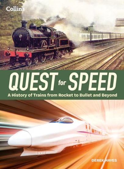
A visual history of high-speed trains. Hop aboard this fascinating journey through the early days of railway trains to the modern day superfast Maglevs which can reach speeds of 600km/h. Exquisitely illustrated with hundreds of photos, both archival and modern, the book is a visual feast for anyone even remotely interested in railways. This is a journey through time and throughout the world, investigating trains that have been considered high-speed in their day. Focused at first in Britain, the birthplace of the railway, the book covers developments in the 19th and 20th centuries across Europe, including the birth of the French TGV, which is credited with kickstarting the modern rise of the high-speed train in the West, inspired itself by the early Japanese Shinkansen—the Bullet Train—in 1964. From steam to diesel to gas turbines to electric and from steel-wheeled to magnetic levitation (maglev), it is all covered in this book, including significant, recent innovations such as driverless trains and maglev on conventional track, which may well be the way of the future. With hundreds of colour photographs, many taken specially for this book, and readable text aimed at all those interested in history and the development of technology—not just railway enthusiasts—Quest for Speed will entertain, fascinate and delight.
The First Railroads: Atlas of Early Railroads
A highly illustrated volume tracing the emergence of modern railways. Praise for the author's previous title, America Discovered "Hayes offers more than just the state's emergent political boundaries and geological elevations. He presents a fascinating, map-based chronicle of the region's legendary gold rush, the gradual domination of its railroads, the development of its diverse ethnic composition, its blazing urban cataclysms, and its role in World War II. While laudably information-dense, the text is also an appealing, highly enjoyable read." --Library Journal In this book, Derek Hayes compiles archival maps and illustrations, many never before published, showing the locations and routes of the world's early railways, as well as the locomotive and rail technology that was key to the development of those railroads. In addition to maps, the illustrations include photos of most of the surviving first locomotives from collections around the world and of replicas too, where they exist. Much of the world's early railways originated in Britain, but Hayes also considers the earliest systems in North America, continental Europe, and elsewhere. The book covers the emergence of the first steam locomotives, including the historically important Stockton and Darlington, the world's first public railway system to use steam locomotives, and Liverpool and Manchester, for its pioneering use of cast iron girders. In addition to mainstream railways, atmospheric railways are considered as well as electric railways, underground railways, monorails, and mountain (rack) railways, all of which have fascinating histories. For The First Railroads, Derek Hayes travelled to most of the locations mentioned and visited railway museums all over the world, amassing a wealth of information and illustrative materials, including never before seen ephemera. Here he proves again his reputation for in-depth research and rare photographs and maps -- and for making it enjoyably readable.
Historical Atlas of the United States

Historical Atlas of the United States

Derek Hayes

University of California Press
2006
sidottu
The evolution of geographical knowledge is presented, along with a fascinating chronicle of the expansion and development of the U.S., in a collection of more than five hundred historical maps covering more than half a millennium and ranging from the earliest days of exploration to the transformation of the Gulf Coast following hurricane Katrina.
Historical Atlas of California

Historical Atlas of California

Derek Hayes

University of California Press
2007
sidottu
Using nearly five hundred historical maps and many other illustrations, a lavishly illustrated volume covers five hundred years of history and offers a compelling and informative look at the transformation of the state from before European contact, through the Gold Rush, and up to the present day.
Historical Atlas of the American West

Historical Atlas of the American West

Derek Hayes

University of California Press
2009
sidottu
Spectacular in scope and visually brilliant, this atlas presents a sweeping history of the American West through more than 600 original, full-color maps and extended captions. From the earliest human inhabitants and the first European explorers to the national parks and retirement resorts of today, this extensive collection chronicles the West from uncharted territory to a well-populated Eden. We bear witness as state lines strike through Native American territories, see the frontier crack open and the railroad's iron belt snake across the Plains, and watch as the West's cities, from Los Angeles to Las Vegas and Albuquerque to Anchorage, rise and prosper. This is the first atlas to compile all the historically significant maps relating to the American West; it includes field sketches of battles, the first maps to show the West, maps depicting mythical rivers and fictional towns, and maps showing early conceptions of California as an island. Distilling many centuries into one fascinating volume, this atlas traces history as redwoods, mountains, and deserts become California, Montana, and Arizona, and offers a rare opportunity to see the west through the eyes of its earliest explorers.
Historical Atlas of the North American Railroad

Historical Atlas of the North American Railroad

Derek Hayes

University of California Press
2010
sidottu
America's long romance with the train has been the subject of many books, but none has used contemporary maps to comprehensively illustrate the story. Until now. Here the latest of Derek Hayes' historical atlases delves into the history of the railroad in North America, from its origins in Britain in the 1820s and short lines connecting Eastern Seaboard rivers in the 1830s to Amtrak and the modern intermodal freights driving today's railroad revival. Colorful and informative, the book covers a vast range of topics and offers an impressive array of types of railroad map, from the purely utilitarian to the gorgeously promotional. Nearly 400 old railroad maps, most in full color, plus many historical photos, brochures, and posters, combine to provide a new perspective on the North American railroad. "Historical Atlas of the North American Railroad" also explains how the railroad transformed the economic and social life of a continent, fundamentally changing the two North American nations it linked from the Atlantic to the Pacific.
Iron Road West

Iron Road West

Derek Hayes

Harbour Publishing
2019
sidottu
British Columbia wouldn't exist without the railway; the province was brought into the Canadian Confederation in 1871 in exchange for the promise of a transcontinental line to the West Coast. It was the arrival of the Canadian Pacific Railway in 1886 that set off economic development in the province, created the city of Vancouver and spurred others to build competing lines. In Iron Road West, Derek Hayes charts the development of the province through its railway lines, using a wealth of photographs and other visuals to show how rails were laid through the wild terrain that characterized much of British Columbia. As railways revolutionized the province, they inevitably incited fierce competition and personal hatreds, creating an exciting frontier-like environment that Hayes describes in vivid detail. The book also covers the emergence of the modern freight railway in British Columbia, including fully automated and computerized trains. An extensive section details our railway legacy, including preserved railways, locomotives and facilities that can still be visited today. Prolifically illustrated, Iron Road West will fascinate not only railway enthusiasts, but anyone with an interest in the history of the province.
Incredible Crossings

Incredible Crossings

Derek Hayes

Harbour Publishing
2023
sidottu
Historian and bestselling author Derek Hayes brings hundreds of colour photographs, archival images and illustrations together with a meticulously researched commentary on the bridges, tunnels and inland ferries that connect British Columbia. The very nature of the topography of BC has meant that engineers have had to be innovative in their solutions to formidable barriers, and the province is home to a multitude of rivers and mountain torrents that had to be bridged to create both railway connections and the modern road network. Their vital nature was exposed in November 2021 when so many bridges in the Coquihalla and Nicola valleys were wrecked by floods and landslides, disrupting the entire province. British Columbia has over three thousand bridges, in a surprising variety, with uses ranging from crossing a river to bungee jumping, and many are graceful works of art and a tempting subject for the photographer. There are collapses and demolitions by explosions as well as challenging bridge relocations. There are suspension bridges, and cable-stayed bridges, both wooden and steel trusses. There were once five covered bridges and one is still left today. Photographer and historian Derek Hayes traversed the province to find crossings with the most interesting stories and structures, combining artistic images and intriguing history in a book for anyone with an interest in engineering, transportation history and the story of the province of British Columbia itself.
Historical Atlas of Canada

Historical Atlas of Canada

Derek Hayes

Douglas McIntyre
2015
pokkari
Maps tells the story in this innovative volume, and the story of Canada they tell is profoundly engrossing and rewarding. The atlas covers a period of a thousand years and contains essentially all the historically significant maps of the country. Gathered from major archives and libraries all over the world, they include treasures from the National Archives of Canada--many never before published--and many from the archives of the Hudson's Bay Company. Included are maps by the founder of New France, Samuel de Champlain, by Philip Turnor and Peter Fidler. There are English maps and French maps; Spanish maps and Russian maps; American, Italian and Dutch maps as well as maps drawn by Native people such as the Beothuk, Blackfoot and Cree. Canada's colourful past unfolds in sumptuous visual detail--history seen from a whole new perspective.
Canada: An Illustrated History

Canada: An Illustrated History

Derek Hayes

Douglas McIntyre
2017
pokkari
From the early days of exploration and settlement to Canada's participation in space exploration and the 2015 federal election, this illustrated history conveys the drama and scope of the nation. Through accessible commentary and a wealth of images, both well-known and obscure facets of Canadian history are presented in this splendid compendium. Read about Canada's first newspaper, the Halifax Gazette, which, in its first iteration, was a single sheet of paper. Find out which Canadian bridge collapsed not once, but twice. Discover the nation's history of crime and punishment, firefighting, the 25-cent and $50,000 bills, Prohibition, early aviation, and much, much more. Here also are the tales of a myriad of individuals who shaped Canada: the famous, the infamous, the popular and the unknown. Hayes details stories of First Nations, separatists and statesmen, astronauts and inventors, motorists, mail carriers, fur traders, photographers and politicians. More than 450 illustrations accompany the text, including 200-plus photographs, 50-plus paintings and drawings (many by Canadian artists) and 35 historic maps, as well as posters, stamps, cartoons, stained glass and tapestries.Canada: An Illustrated History is a visual experience every Canadian can enjoy.
British Columbia

British Columbia

Derek Hayes

Douglas McIntyre Publishing Group
2020
pokkari
Early depictions of the West Coast were no more than cartographers’ fanciful guesses. Not until the discovery of “soft gold”—sea otter pelts—and the quest to find a Northwest Passage did explorations, such as the epic voyage of George Vancouver, lead to a better understanding of the region’s geography. Even so, until the gold rush of 1858, the interior of the province was mostly unknown except for the routes blazed by fur traders. Thirteen years later, British Columbia became a province of Canada, and a transcontinental railway was built to connect the land west of the Rocky Mountains with the rest of the country. The efforts of these early explorers, fur traders, gold seekers and builders involved the production of maps that showed what they had found and what they proposed to do. British Columbia: A New Historical Atlas reveals the plans and strategies that created the province we know today through a fascinating visual lens—from maps by early Indigenous inhabitants and the Europeans who arrived to explore and exploit vast resource wealth, to maps drawn by those who, decades later, prepared for war, built dams, promoted real estate and even tracked murders. Presented alongside award-winning historian Derek Hayes’s lively and authoritative text, this unprecedented collection of over 900 maps plus 300 photos and historical documents offers a unique, geographical history. This is the story of both the dreams that came true and those that didn’t—yet all are part of the dramatic tale of the forging of Canada’s western frontier.
Coastal Connections: A History of British Columbia Ferries and Passenger Ships
Award-winning historian and photographer Derek Hayes examines the long and colorful history of ferries and ships linking the BC coast. From early paddle-wheelers like the S.S. Beaver to the latest high-speed catamaran, ferries and passenger vessels have always been central to the lives and livelihoods of British Columbians, connecting Vancouver Island, hundreds of smaller islands and a rugged mainland coastline to the rest of the province. This history culminated in the creation of BC Ferries, whose vessels today serve every part of coastal BC. In Coastal Connections, historian Derek Hayes describes early attempts to provide links between the Mainland and Vancouver Island as well as the upper mainland coast. There was Canadian Pacific, with its fleet of Pacific Princesses; Canadian National, with its counterbalancing fleet of Prince ships serving the new city at the end of its northern line, Prince Rupert; and Union Steamships, which provided service to small BC Coast settlements for over 70 years. Then came BC Ferries. Starting in 1960 with just two ships, it has grown to become one of the world's largest ferry fleets, with 35 ships carrying over 22 million passengers and nearly 10 million vehicles a year over more than 25 routes. Illustrated with hundreds of archival and modern photographs, artworks and ephemera, the book is a visual treat for anyone interested in the coastal history of British Columbia, the BC Ferries fleet and its operations.