There have been wars throughout the history of mankind with one group attempting to take over an area from another group. Wars affect the people who survive as well as doing a tremendous amount of damage to the landscape. In this book, I have provided an overview of some of the major acts of destruction that have occurred in the 20th and 21st centuries. The book begins with World War I and my grandfather's part in it, and continues with World War II and my mother's experiences in England during it. The situation in Ireland escalated for many decades in the twentieth century with some wanting to make all Ireland free from Great Britain although the majority of those in Northern Ireland wanted to stay with the United Kingdom. The Korean and Vietnam Wars caused lots of bloodshed and destruction to the land in those countries. Berlin became divided between the east and west and a solid wall was built between the two areas which kept people from leaving East Berlin from 1961 to 1990 when the wall began to come down and free travel was permitted once again. President John F. Kennedy was assassinated in 1963. Problems arose in the Suez Canal area from 1956 onwards, and the Middle East erupted with the Yom Kippur War in 1973 with fighting for control of the area continuing to this day. There have been many incidents of shootings at schools around the world and I have provided a brief description of a small number of them. Cuba has been a hotbed of trouble for the United States with their fear of the spread of communism and their thwarted attempts to take control of the island nation. The Chernobyl Nuclear disaster in 1986 caused much environmental damage to the area and the people in the surrounding area were displaced from their homes and are still unable to return for any of their belongings. Jumbo jet crashes due to pilot error were an interesting topic to research, while ditching of planes in the water where many have been rescued showed quick thinking on the part of the pilots. Tiananmen Square in Peking is discussed and analyzed, as well as Nelson Mandela and his work to end apartheid in South Africa and give rights to the vast majority of blacks living in the country. A snapshot is provided of the Kuwait Gulf War as well as war in Afghanistan and Iraq. The Siege of Sarajevo was brought to light in the book I read, "The Cellist of Sarajevo" by Steven Galloway. The Oklahoma City bombings, 9/11 Twin Towers terrorist attacks, and London, England bombings are discussed. A senator is shot down, the Boston Marathon ends with destruction of lives when bombs are detonated near the finish line, a garment factory collapses in Bangladesh killing about a thousand workers, and a man from our area, Tim Bosma from Ancaster is kidnapped. Good news is scattered amongst the agony when we hear of the release of three young women who had been kidnapped ten years ago in Ohio; this brings to mind the book, "A Stolen Life" by Jaycee Dugard who was kidnapped at age 11, kept for 18 years before she was freed, having given birth to two daughters by the kidnapper, the first one at age 14. Wars, terrorist attacks and major disasters continue to be present in our world. What really counts is our response and reaction to them. We can live in fear of what might happen, or we can take each day as it comes and make the best of whatever presents itself.
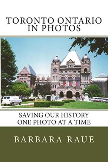
Toronto, Ontario is the subject of Book 26 in the Cruising Ontario series of books of photographs of towns and cities in Ontario, saving our history one photo at a time. The photos show the architecture and design of old buildings contrasted with the new skyscrapers. Toronto is the largest city in Canada and is the provincial capital of Ontario. In 1954, the City of Toronto and twelve surrounding municipalities joined together into a regional government known as Metropolitan Toronto. The postwar boom resulted in rapid suburban development, and the metropolitan government began to manage services that crossed municipal boundaries, including highways, police services, water and public transit. Toronto covers an area of 630 square kilometres stretching 21 kilometres (13 miles) from north to south distance and 43 kilometres (27 miles) east. The Lake Ontario waterfront shoreline is 46 kilometre (29 miles) long.
Beaver Valley, Ontario is the subject of Book 27 in the Cruising Ontario series of books of photographs of towns and cities in Ontario. The photos show the architecture and design of old buildings, many that are over 100 years old, with some descriptions of the buildings and background information but mostly it is a visual experience to enjoy as we Save Our History One Photo at a Time. The towns included in the Beaver Valley Book are Clarksburg, Craigleith, Flesherton, Heathcote, Leith, Markdale, Meaford, Thornbury, Victoria Corners, and Walter's Falls.
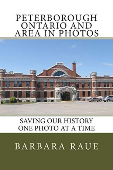
Peterborough, Ontario is the subject of Book 29 in the Cruising Ontario series of books of photographs of towns and cities in Ontario, saving our history one photo at a time. The photos show the architecture and design of old buildings and background information, but mostly it is a visual experience to enjoy. The book includes pictures in Peterborough, Bridgenorth on Chemong Lake, Emerald Isle on Buckhorn Lake, and Ennismore. We have travelled to Peterborough many times, sometimes on our way to a campground, sometimes on our way to Ottawa, other times on our way to Emerald Isle and Cow Island to visit my cousins.
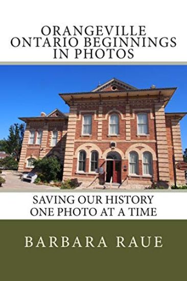
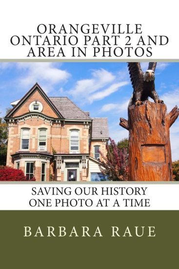
John Corbit acquired land in the area in 1829 and is one of the earliest settlers. Spring Brook (also called Mill Creek), a tributary of the Credit River, provided water for power for several mills located downstream. Seneca Ketchum and George Grigg arrived soon after. By 1844 when Orange Lawrence and his wife Sarah arrived from Connecticut, a well-established community called Grigg's Mill existed beside Mill Creek.Orange Lawrence helped to develop the community, laying out the southeast part of town; he opened a general store and a tavern, built a second mill, founded the first school, and became the village's first postmaster in 1847. He left a strong mark on the community which took the appropriate name of Orangeville.Immigrants from Ireland and other parts of the British Isles and Canada West came throughout the 1840s and 1850s with some establishing successful mixed farms while others settled in the village and became the landowners, merchants, and tradesmen whose needs led to the development of good transportation routes. By the 1860s it was increasingly difficult to deliver and receive goods to and from the supply centres in the south with gravel roads that were difficult to traverse by horse and wagon for much of the year. Winter was the season when most goods were transported by sleigh over frozen roads.By 1871 two daily stage lines were operating between Orangeville and Brampton, and that year the Toronto, Grey and Bruce Railway reached Orangeville, thanks to the efforts of the town fathers such as Jesse Ketchum Jr., Samuel and Robert McKitrick, Johnston Lindsey, Thomas Jull, John Foley, and R. William Armstrong.By 1875 there was a foundry, three planning mills, two saw mills, a tannery, a carding mill, several carriage and wagon manufacturers, and a successful pottery business in operation, along with four grocers, three hardware merchants, two drugstores, three watchmakers, three bakeries, and three establishment proving boots and shoes.It was the foresight of Orange Lawrence and Jesse Ketchum that had large sections of land on either side of the main street laid out for both commercial and residential building lots. The south side followed Mill creek while a regular grid pattern was determined for the streets on the north side from first to Fifty Streets both east and west and north to Fifth Avenue, with a wide main street called Broadway. This 30-metre (100-foot) avenue was not typical of Ontario towns of the time but has proven to be very valuable over the years. In 1875 the Town Hall was construction, and in 1887 the first telephone exchange was established.Orangeville is proud of its roots and seeks to preserve its heritage. With two of our children and five grandchildren living in Orangeville, we often make the trek to the town. I have walked and driven the streets of Orangeville discovering its beauty. There are hundreds of old buildings which have retained their 1800s architectural styles and character. As a result, I have divided the pictures into two books. The first book covers the beginnings of Orangeville with pictures from the south side of town, and buildings on Broadway. An appendix is included to describe architectural styles and terms which are referred to throughout the book. The second book covers buildings to the north of the town, as well as pictures taken in surrounding villages of Laurel, Caledon Village and Mono Centre.
John Corbit acquired land in the area in 1829 and is one of the earliest settlers. Spring Brook (also called Mill Creek), a tributary of the Credit River, provided water for power for several mills located downstream. Seneca Ketchum and George Grigg arrived soon after. By 1844 when Orange Lawrence and his wife Sarah arrived from Connecticut, a well-established community called Grigg's Mill existed beside Mill Creek.Orange Lawrence helped to develop the community, laying out the southeast part of town; he opened a general store and a tavern, built a second mill, founded the first school, and became the village's first postmaster in 1847. He left a strong mark on the community which took the appropriate name of Orangeville.Immigrants from Ireland and other parts of the British Isles and Canada West came throughout the 1840s and 1850s with some establishing successful mixed farms while others settled in the village and became the landowners, merchants, and tradesmen whose needs led to the development of good transportation routes. By the 1860s it was increasingly difficult to deliver and receive goods to and from the supply centres in the south with gravel roads that were difficult to traverse by horse and wagon for much of the year. Winter was the season when most goods were transported by sleigh over frozen roads.By 1871 two daily stage lines were operating between Orangeville and Brampton, and that year the Toronto, Grey and Bruce Railway reached Orangeville, thanks to the efforts of the town fathers such as Jesse Ketchum Jr., Samuel and Robert McKitrick, Johnston Lindsey, Thomas Jull, John Foley, and R. William Armstrong.By 1875 there was a foundry, three planning mills, two saw mills, a tannery, a carding mill, several carriage and wagon manufacturers, and a successful pottery business in operation, along with four grocers, three hardware merchants, two drugstores, three watchmakers, three bakeries, and three establishment proving boots and shoes.It was the foresight of Orange Lawrence and Jesse Ketchum that had large sections of land on either side of the main street laid out for both commercial and residential building lots. The south side followed Mill creek while a regular grid pattern was determined for the streets on the north side from first to Fifty Streets both east and west and north to Fifth Avenue, with a wide main street called Broadway. This 30-metre (100-foot) avenue was not typical of Ontario towns of the time but has proven to be very valuable over the years. In 1875 the Town Hall was construction, and in 1887 the first telephone exchange was established.Orangeville is proud of its roots and seeks to preserve its heritage. With two of our children and five grandchildren living in Orangeville, we often make the trek to the town. I have walked and driven the streets of Orangeville discovering its beauty. There are hundreds of old buildings which have retained their 1800s architectural styles and character. As a result, I have divided the pictures into two books. The first book covers the beginnings of Orangeville with pictures from the south side of town, and buildings on Broadway. An appendix is included to describe architectural styles and terms which are referred to throughout the book. The second book covers buildings to the north of the town, as well as pictures taken in surrounding villages of Laurel, Caledon Village and Mono Centre.
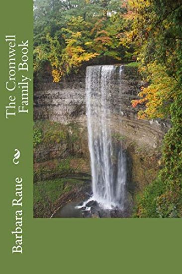
The story of the Cromwell Family is rich in history.When I was growing up, I was told that our family line had been traced back to a connection with Oliver Cromwell, Lord Protector of England. When I began my research in the 1990s, I was able to get back as far as the late 1700s when the United Empire Loyalists came to Canada in 1783. I also did research from Oliver Cromwell backwards several generations through the Welsh connections. I was still missing the 150 years from Oliver and Richard Cromwell to Henry Cromwell in New Brunswick.In 2011, Bert and Mary Wood provided the connecting information, filling in the missing links to have a complete tree back to the 1100s. What a thrill that has been as I have continued to add information and background information. I am the 14th generation from Sir Philip Cromwell (1578-1630), the brother of Robert Cromwell who was the father of Oliver Cromwell who became Lord Protector of England. This begins the 150 year link that was missing from my research for many years.The Cromwell kindred got their name from the village of Cromwell which is about five miles north of Newark in Nottinghamshire. With my interest in royalty, I have included a chapter on the Sovereigns of Britain from William the Conqueror to the present Queen Elizabeth and interconnect them with the Cromwells living during their reigns.Walter Cromwell twice discharged the office of "Constable of Putney," in 1495 and 1496, a parochial office that was held in turn by the principal householders in a parish. Three children survived him - Katharine, born about 1477; Thomas, about 1485; and Elizabeth, about 1487.Katharine Cromwell married a man of Welsh extraction named Morgan Williams. From the issue of this marriage sprung in the fourth generation the Lord Protector of England, Oliver Cromwell.Katharine Cromwell and Morgan Williams had a son named Richard. He most likely joined the royal bodyguard of Welshmen and became proficient in the use of arms. At a grand tournament held by the King in 1539 he was successful in defeating a Mr. Culpeper and two of the bravest foreign champions who had been invited from the Continent to take part in the royal festivities. Henry VII was delighted with Cromwell's success in beating the two foreigners and gave him a ring from his own finger and made him his knight. Richard abandoned his father's surname "Williams" and assumed that of his mother's family "Cromwell," proclaiming his close kinship to the king's chief advisor and minister Thomas Cromwell, Earl of Essex. In memory of the great tournament, Sir Richard Cromwell and his descendants adopted as their crest a lion rampant holding up a ring in his right paw.When monasteries, abbeys and priories were suppressed and their broad acres and immense wealth seized by King Henry and his minister Thomas Cromwell, his nephew Sir Richard and his heirs secured the possession of extensive estates and manors in the county of Huntingdon by royal favour. Three members of the family were knighted by three successive sovereigns - Richard by Henry VIII, Henry by Queen Elizabeth, and Oliver by James I.Discover the interconnections throughout history tying the family into historical events that helped shape the English world.
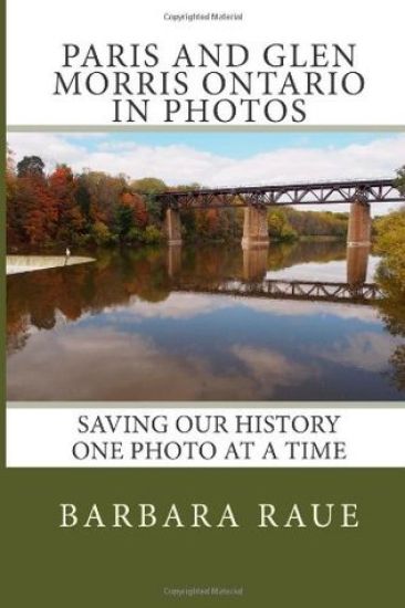
Paris, Ontario is located at the Forks of the Grand, where the Grand and Nith Rivers meet. It was first settled by Hiram Capron who came to Norfolk County in 1822 where he helped to establish one of Upper Canada's first iron foundries. In 1830 he constructed a grist-mill and named the town after the gypsum deposits that were mined nearby. Gypsum is used to make plaster of Paris. Paris is often referred to as the "cobblestone capital of Canada" because of the many cobblestone buildings that are still found in the town. Cobblestone architecture refers to the use of cobblestones embedded in mortar to erect walls of houses and commercial buildings. We often make a trip to Paris to wander the streets, visit the shops and have a cup of coffee at Tim Horton's.Glen Morris is located on East River Road, Brant County Road #14. The German Woolen Mill was built in 1867 and operated for several years. The Glen Morris General Store is located on Princess Street. Glen Morris is located about 22 kilometres northwest of Brantford, 11 kilometres southwest of Cambridge, and 11 kilometres northeast of Paris. My great grandmother, Elizabeth Carter Cromwell, is buried in Glen Morris Cemetery.
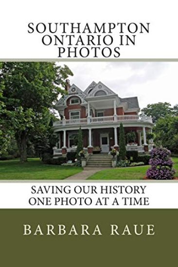
Southampton Ontario is the subject of Book 33 in the Cruising Ontario series of books of photographs of towns and cities in Ontario. Southampton, on Lake Huron at the mouth of the Saugeen River, is located south of Sauble Beach and north of Port Elgin. It is quiet and peaceful on Southampton's beach, a four-kilometre-long stretch of shore. The wooden Long Dock extends towards Chantry Island with its lighthouse in view offshore.Captain John Spence built a cabin near the mouth of the river in 1849, becoming Southampton's first permanent settler. His wife and family joined him the following year. He bought the fishing schooner "Sea Gull" for coastal trade along the shores of Lake Huron.Architectural styles and terms are described in the appendix.
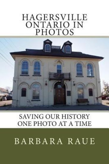
Hagersville, a community in Haldimand County, is located 45 kilometres southwest of Hamilton, Ontario, and 15 kilometres southwest of Caledonia.In 1852, Charles Hager built a frame hotel at the corner of the Plank Road and Indian Line. With the construction of the Plank Road, a small village popped up in 1855 when Charles and David Hager bought most of the land in the center of the area. David Almas owned the land on the east side of the road, while John Porter owned the land in the west end. Joseph Seymour suggested the community be called Hagersville to honour the Hager brothers.Hagersville gained notoriety in 1990 when a huge uncontrolled tire fire spewed toxic smoke into the atmosphere for seventeen days. Architectural styles and terms are described in the appendix.
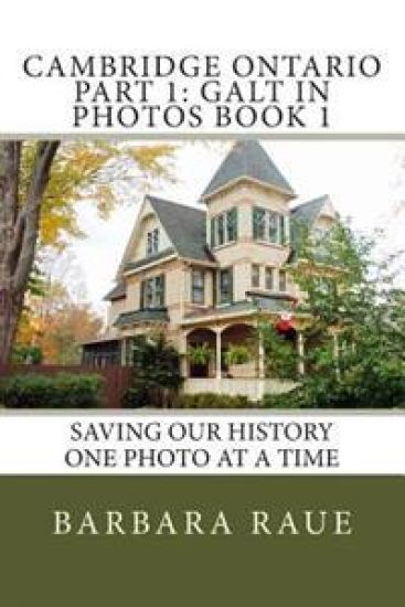
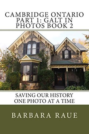
In 1784 the British Crown granted to the Six Nations Indians, in perpetuity, all the land along the Grand River six miles deep on each side of the river from its source to Lake Erie. The Indians, led by Joseph Brant, had the land surveyed in 1791 and divided into Indian Reserve lands as well as large tracts which they intended to sell to land developers. One such developer was the Honourable William Dickson who, in 1816, came into sole possession of 90,000 acres of land along the Grand River which later made up North and South Dumfries Townships.It was Mr. Dickson's intention to divide the land into smaller lots to sell to the Scottish settlers that he hoped to attract to Canada. For the town site, the place where Mill Creek flows into the Grand River was chosen and in 1816 the settlement of Shade's Mills began. When the Post Office opened in 1825, the new name of Galt was chosen for the town in honour of the Scottish novelist and Commissioner of the Canada Company, John Galt.In its early days Galt was an agricultural community serving the needs of the farmers in the surrounding countryside. By the late 1830s, the settlement began to develop industrially and acquired the reputation for quality products that in later years earned the town the nickname "The Manchester of Canada".In the late 1960s the provincial government began looking at ways in which municipal governments could become more effective. On January 1, 1973, the City of Galt was amalgamated with the towns of Preston and Hespeler to form a single city, the new city being called Cambridge.
In 1784 the British Crown granted to the Six Nations Indians, in perpetuity, all the land along the Grand River six miles deep on each side of the river from its source to Lake Erie. The Indians, led by Joseph Brant, had the land surveyed in 1791 and divided into Indian Reserve lands as well as large tracts which they intended to sell to land developers. One such developer was the Honourable William Dickson who, in 1816, came into sole possession of 90,000 acres of land along the Grand River which later made up North and South Dumfries Townships.Mr. Dickson's intention was to divide the land into smaller lots to sell to the Scottish settlers that he hoped to attract to Canada. For the town site, the place where Mill Creek flows into the Grand River was chosen and in 1816 the settlement of Shade's Mills began. When the Post Office opened in 1825, the new name of Galt was chosen for the town in honour of the Scottish novelist and Commissioner of the Canada Company, John Galt.In its early days Galt was an agricultural community serving the needs of the farmers in the surrounding countryside. By the late 1830s, the settlement began to develop industrially and acquired the reputation for quality products that in later years earned the town the nickname "The Manchester of Canada".In the late 1960s the provincial government began looking at ways in which municipal governments could become more effective. On January 1, 1973, the City of Galt was amalgamated with the towns of Preston and Hespeler to form a single city, the new city being called Cambridge.
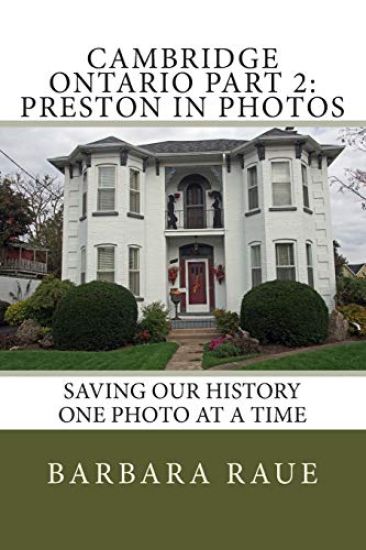
John Erb, the founder of Preston, was born in Lancaster County, Pennsylvania, a Mennonite of Swiss ancestry. He came to Upper Canada in 1805, acquired 7,500 acres of land from the German Land Company and settled on the site of Preston where the Grand and Speed Rivers meet. He built a sawmill and a gristmill and the community grew around them. The town was originally known as "Cambridge Mills" and was later renamed after Preston, England.Preston's location on the Great Road into the interior of the province made it a natural stop for travellers and with its eight hotels and taverns attracted more Europeans than any other village in the area.
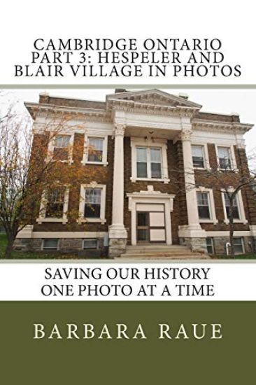
Blair VillageThe Bowman and Bechtel families are credited with starting the development of the village of Blair. Joseph Bowman built the first dam in the village, located on Bowman Creek, and erected the area's first sawmill, the first industrial enterprise in the village. Henry Bechtel built the Durham Flour Mill in the early 1830s. Blair Village became part of Preston in 1969 and became part of Cambridge in 1973.HespelerThis area was originally part of the land granted to the Six Nations Indians by the British Crown in 1784. The Indians led by Joseph Brant sold part of their block of land measuring 90,000 acres to Richard Beasley and his partners. A group of Pennsylvania Mennonites agreed to buy some of the land and began arriving in the Hespeler area in 1809. The most important of the area's early settlers was Jacob Hespeler, the man who gave the settlement its permanent name. Jacob Hespeler was born in Germany, educated in France and emigrated to Canada with eight of his brothers and sisters. In about 1835 he moved to the German community of Preston where he opened a store. He looked for land in order to build a grist mill and found a suitable site on the Speed River in the settlement of New Hope. He also built a sawmill, a cooperage, a gas house, a distillery and a stone woollen mill. The name of the village was changed to Hespeler in 1859 with the arrival of the Great Western Railway.
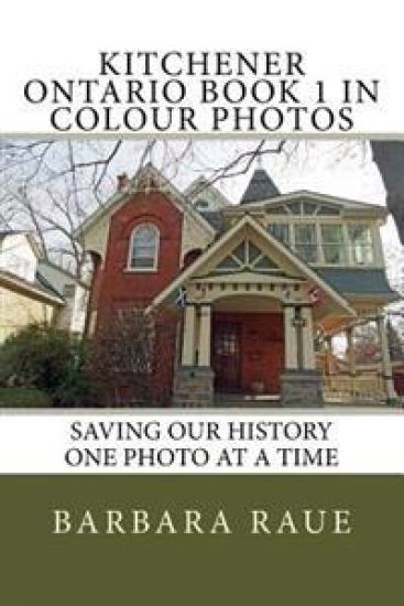
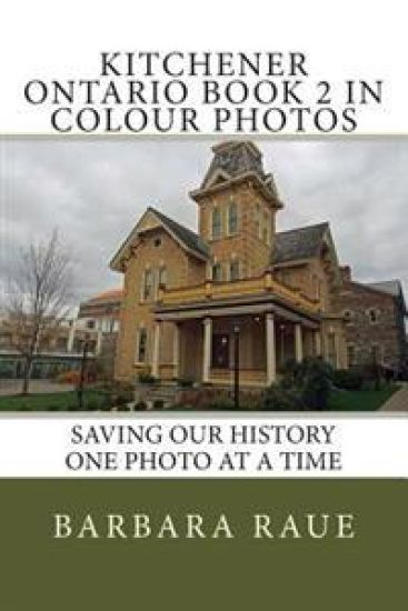
Kitchener is located in Southwestern Ontario in the Grand River Valley. The settlement's first name, Sand Hills, is an accurate description of the higher points of the Waterloo Moraine which snakes its way through the region and holds a significant quantity of artesian wells from which the city derives most of its drinking water.In 1784, the land that Kitchener was built upon was an area of 240,000 hectares of land given to the Six Nations by the British as a gift for their allegiance during the American Revolution. The Six Nations sold 38,000 hectares of this land to Loyalist Colonel Richard Beasley, land that was remote but of great interest to German Mennonite farming families from Pennsylvania. They wanted to live in an area that would allow them to practice their beliefs without persecution. The Mennonites purchased all of Beasley's unsold land creating 160 farm tracts. By 1800, the first buildings were built, and over the next decade several families made the difficult trip north to Sand Hills. One of these Mennonite families, arriving in 1807, was the Schneiders, whose restored 1816 home (the oldest building in the city) is now a museum located in the heart of Kitchener.Much of the land, made up of moraines and swampland interspersed with rivers and streams was converted to farmland and roads. Apple trees were introduced to the region by John Eby in the 1830s, and several grist and sawmills were erected throughout the area. Schneider built the town's first road from his home to the corner of King Street and Queen Street (then known as Walper corner), $1000 was raised by the settlers to extend the road from Walper corner to Huether corner, where the Huether Brewery was built and the Huether Hotel now stands. In 1833 the town was renamed Berlin. The extension of the Grand Trunk Railway from Sarnia to Toronto and through Berlin in July 1856 was a major boon to the community helping to improve industrialization in the area. Through the latter half of the 19th century and into the first decade of the 20th, the City of Berlin was a bustling industrial centre celebrating its German heritage. When World War I started, that heritage became the focus of considerable enmity from non-German residents, and resulted in the name being changed to Kitchener.On September 17, 1981 the first-ever "blue box" recycling program in the world was launched in Kitchener. Today over 90% of Ontario households have access to recycling programs.Kitchener's economic heritage is rooted in manufacturing. While the local economy's reliance on manufacturing has decreased in recent years, more than 20% of the labour force remains employed in the manufacturing sector.
Kitchener is located in Southwestern in the Grand River Valley. The settlement's first name, Sandhills, is an accurate description of the higher points of the Waterloo Moraine which snakes its way through the region and holds a significant quantity of artesian wells from which the city derives most of its drinking water.In 1784, the land that Kitchener was built upon was an area of 240,000 hectares of land given to the Six Nations by the British as a gift for their allegiance during the American Revolution. The Six Nations sold 38,000 hectares of this land to Loyalist Colonel Richard Beasley, land that was remote but of great interest to German Mennonite farming families from Pennsylvania. They wanted to live in an area that would allow them to practice their beliefs without persecution. The Mennonites purchased all of Beasley's unsold land creating 160 farm tracts. By 1800, the first buildings were built, and over the next decade several families made the difficult trip north to Sand Hills. One of these Mennonite families, arriving in 1807, was the Schneiders, whose restored 1816 home (the oldest building in the city) is now a museum located in the heart of Kitchener.Much of the land, made up of moraines and swampland interspersed with rivers and streams was converted to farmland and roads. Apple trees were introduced to the region by John Eby in the 1830s, and several grist and sawmills were erected throughout the area. Schneider built the town's first road from his home to the corner of King Street and Queen Street (then known as Walper corner), $1000 was raised by the settlers to extend the road from Walper corner to Huether corner, where the Huether Brewery was built and the Huether Hotel now stands. In 1833 the town was renamed Berlin. The extension of the Grand Trunk Railway from Sarnia to Toronto and through Berlin in July 1856 was a major boon to the community helping to improve industrialization in the area. Through the latter half of the 19th century and into the first decade of the 20th, the City of Berlin was a bustling industrial centre celebrating its German heritage. When World War I started, that heritage became the focus of considerable enmity from non-German residents, and resulted in the name being changed to Kitchener.On September 17, 1981 the first-ever "blue box" recycling program in the world was launched in Kitchener. Today over 90% of Ontario households have access to recycling programs.Kitchener's economic heritage is rooted in manufacturing. While the local economy's reliance on manufacturing has decreased in recent years, more than 20% of the labour force remains employed in the manufacturing sector.