Egmont es un pr ncipe que debe casarse con una princesa, pero no hay ninguna en el reino que le llegue al coraz n. Un d a conoce a una hermosa muchacha en mitad de un lago, la princesa de las hadas acu ticas, Asrai. Ambos son de mundos distintos, una maldici n cae sobre ellos... Podr n estar juntos, casarse, ser felices y comer perdices?
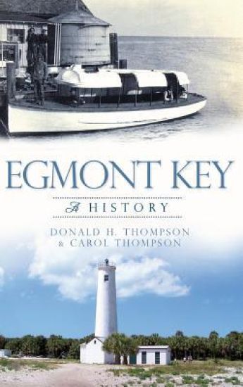
Egmont Key has been a sentinel for ships entering Tampa Bay from the Gulf of Mexico for hundreds of years. Early European explorers recognized the island's strategic location. Its story reflects major events in the history of the United States and Florida, as the island played a role in the Seminole Wars, the Civil War, the Spanish-American War and World Wars I and II. Its lighthouse, now automated, is still a beacon for ships. For many years, people have enjoyed the beaches of Egmont Key, walked the red brick "roads to nowhere" and explored the ruins of Fort Dade. Authors Don and Carol Thompson aim to foster an appreciation of the uniqueness and beauty of Egmont Key, as well as an understanding of its place in history.
Updated edition. Complete map of the Egmont National Park and surrounding area, great walks with breathtaking views and wonderful tramping/hiking trails in the area. Large scale, highly detailed topographic map 1:25.000 & 20 meter contours for hiking and trekking, printed as an atlas book (with overlapping pages).Around the Mountain Circuit (AMC), Curtis Falls Track, Dawson Falls & Stratford Plateau tracks, Wilkies Pools, Fanthams Peak/Panitahi and Syme Hut, Taranaki Ring Plain, Kaitake Range walking tracks, Kamahi Forest & Kamahi Loop Track, Mt Taranaki from Maketawa Hut Circuit & Summit Tracks, Pouakai Circuit, Veronica Loop Track, Waingongoro tracks, York Road Loop Track etc.20 meter contour lines, road network, trails & paths, transportation, food, campsites, shelters, guest houses & hotels.Mercator projection with both UTM and WGS84 coordinate grids.The map scale of 1:25000 (1 cm = 250 meters) provides a wealth of detail while keeping low the weight of the atlas itself. The largepage format of 8.5x11in minimizes page count and along with an overlapping map design allows for comfortable navigation. The details included in the topographic maps of this atlas were specifically selected to be useful for trekkers, hikers and walkers of all interests, and make it easy to plan and enjoy both short excursions and hikes as well as long multi-day adventures along the main marked routes and/or adjacent trails and paths, which are also shown on the maps.With this ultralight atlas you will always have a detailed, reliable, information-rich, battery-independent, shatter-proof map for your adventure.


![[Egmont - Ein Trauerspiel in Fünf Aufzügen]](/covers/9783111216218.jpg)

![[Egmont - Ein Trauerspiel in Fünf Aufzügen]](/covers/9783112694954.jpg)