Kirjojen hintavertailu. Mukana 11 244 527 kirjaa ja 12 kauppaa.

Kirjahaku

Etsi kirjoja tekijän nimen, kirjan nimen tai ISBN:n perusteella.

1000 tulosta hakusanalla Stephan Mitsch

London Pop-Up Map by Vandam

London Pop-Up Map by Vandam

Stephan Van Dam

Vandam
2023
kartta, viikattu
VanDam's London UNFOLDS Pop-Up maps all top attractions including museums, monuments, architecture, hotels, shops and theaters plus the Tube at an immensely legible scale of 1:20,000 complete with 3-D building illustrations. Clear information design allows users to read the map from three feet away and has earned VanDam maps a place in the MoMA Collection. The map is laminated, pocket size and unfolds to 12 times its original size, then refolds itself when closing the covers. The map easily fits into your pocket or purse.Coverage: London City Street Map 1:20,000; The West End Map: 1:14,000; Theatreland Detail Map: 1:9,000 Central London & Docklands Map London Tube Map Dimensions: 3.75 x 6 folded, 8.5 x 11 unfolded per section.London UNFOLDS Pop-Up is so legible you will instantly understand how The City connects with Covent Garden, Hampstead Heath with Hoxton, Kensington with Knightsbridge and Tate Modern with the Tower of London. From God's perspective to the most minute alleys our map will be a treasured companion during your stay.Despite a 2,000 year history the City never had an urban masterplan. Londontown is an agglomeration of medieval villages which form the heart of the metropolis we all love. Turn a corner and new worlds unfold. London is unique in many ways. It is the only city to boast an entire street designated for men's fashion needs: Jermyn Street in St James's. Discerning gents buy their fragrances at Geo F Trumper, dine at Wilton's, get their bespoke shirts at Turnbull & Asser, shoes at John Lobb and accessories at Dunhill. After window shopping, cut through Piccadilly Arcade for High Tea and cuke sandwiches at Fortnum & Mason's 4th floor Diamond Jubilee Salon. One of the great pleasures of being here is hearing the English language flexed. In theatres and on the street where locals take the time to chat about any subject. British cheer remains the lingua franca despite Brexit.Among our favorite walks: from The Mile Square City, now the Financial Centre, to St Paul's crossing Millennium Bridge to Tate Modern with grand views back over the Thames. Knightsbridge and Belgravia are among the toniest neighborhoods. Start at Harrods, the mother of all department stores, to see the latest fashions and taste from the mind-boggling selections of hams on the ground floor, then walk off the calories in Hyde Park with a visit to Serpentine Gallery for cutting edge art and design. Or start the day sipping cappuccino at the London Review of Books store on Bury Pl, then take the 55 bus from Bloomsbury to the Sunday Flower Market on Columbia Rd in East London with lunch at Rochelle Canteen on Arnold Circus. Stroll down Brick Lane to check out the latest East End fashions. Whatever excursions you plan our laminated pocket sized map will make you travel with confidence and help create lasting memories.London UNFOLDS Pop-Up includes a Central London Map plus a stunning dimensional detail of The West End so you can do historic walks and easily manage the maze of Soho, Theatreland, Piccadilly, Trafalgar Sq and St James's. The map scale of 1:14,000 makes you feel you are there with 3D buildings illustrations as your compass. All Tube stops are marked by their respective line in context right on the main map and on a separate Tube overview so you know both the local details and understand the larger system.London UNFOLDS Pop-Up maps are most current. Its film lamination is extra durable and will last for your next trip. Simplicity reigns to make complex cities clear and understandable. Each map opens to 36" x 9" and then folds down to 4"x 9". Gain instant London StreetSmarts.
Streetsmart Atlanta Map by Vandam

Streetsmart Atlanta Map by Vandam

Stephan Van Dam

Vandam
2017
kartta, viikattu
VanDam's award-winning Atlanta StreetSmart maps all top attractions including museums, major architecture, hotels, and the sports and convention centers. - all at an immensely legible super-scale of 1:11,500, complete with 3-D building illustrations. Clear information design allows users to read the map from three feet away and has earned VanDam maps a place in the MoMA Collection.Atlanta StreetSmart includes a stunning dimensional detail of Downtown Atlanta as well as the Atlanta Metro area.Simplicity reigns supreme in information design to make complex cities clear and understandable. Our typography creates character and reveals the true bones of the city. VanDam uses a letter grid to identify locations on maps - no confusing and cluttering K-28 or V-34s - its just the city from A-Z. Our covers map the icons of each city and turn them into collectible graphic art. Each sleek and laminated city map package opens to 24" x 9" and then easily folds down to 4" x 9" to snuggly fit into a shirt pocket or purse. Gain instant Atlanta StreetSmarts and a sexy souvenir to boot!
Streetsmart San Antonio Map by Vandam

Streetsmart San Antonio Map by Vandam

Stephan Van Dam

Vandam
2017
kartta, viikattu
VanDam's award winning San Antonio StreetSmart maps all top attractions, hotels, major architecture, and shopping - all at an immensely legible super-scale of 1:10,800, complete with 3-D building illustrations. Clear information design allows users to read the map from three feet away and has earned VanDam maps a place in the MoMA Collection.San Antonio StreetSmart includes a stunning dimensional detail of Downtown San Antonio and Metro San Antonio.Simplicity reigns supreme in information design to make complex cities clear and understandable. Our typography creates character and reveals the true bones of the city. VanDam uses a letter grid to identify locations on maps - no confusing and cluttering K-28 or V-34s - its just the city from A-Z. Our covers map the icons of each city and turn them into collectible graphic art. Each sleek and laminated city map package opens to 24" x 9" and then easily folds down to 4" x 9" to snuggly fit into a shirt pocket or purse. Gain instant San Antonio StreetSmarts and a sexy souvenir to boot!
Streetsmart Madrid Map by Vandam

Streetsmart Madrid Map by Vandam

Stephan Van Dam

Vandam
2025
kartta, viikattu
VanDam's award-winning Madrid StreetSmart maps all top attractions including museums, major architecture, hotels, and shopping destinations - all at an immensely legible super-scale of 1:2,400, complete with 3-D building illustrations. Clear information design allows users to read the map from three feet away and has earned VanDam maps a place in the MoMA Collection.Madrid StreetSmart includes a stunning dimensional detail of Centro, Parque del Buen Retiro, Ciudad Jardin-Salamanca, and Cuatro Caminos-Trafalgar. Edition includes a Madrid Transit map.Simplicity reigns supreme in information design to make complex cities clear and understandable. Our typography creates character and reveals the true bones of the city. VanDam uses a letter grid to identify locations on maps - no confusing and cluttering K-28 or V-34s - its just the city from A-Z. Our covers map the icons of each city and turn them into collectible graphic art. Each sleek and laminated city map package opens to 24" x 9" and then easily folds down to 4" x 9" to snuggly fit into a shirt pocket or purse. Gain instant Madrilleno StreetSmarts and a sexy souvenir to boot!
Streetsmart Hong Kong Map by Vandam

Streetsmart Hong Kong Map by Vandam

Stephan Van Dam

Vandam
2017
kartta, viikattu
"VanDam's StreetSmart Hong Kongmaps all top attractions including museums, major architecture, hotels, theaters, shopping destinations, beaches, hiking spots and the transit system for Hong Kong, Kowloon and the New Territories all at an immensely legible scale of 1:14,000, complete with 3-D building illustrations. Clear information design allows users to read the map from three feet away and has earned VanDam maps a place in the MoMA Collection. The map is film laminated and fits conveniently into a pocket or purse. Dimensions are" 9" x 4" closed; 9" x 24" open.Contents: Kowloon Street Map Hong Kong Street Map New Territories Map MTR/KTR Transit MapStreetSmart Hong Kong includes a complete overview of Metro Hong Kong and the New Territories plus stunning details of Kowloon, and Hong Kong with Victoria Harbour, Central, Happy Valley, Noho, Soho, Causeway Bay and North Point. The Transit Map show all MTR, KCR trains.StreetSmart Hong Kong Aside from the fact that Hong Kong sports some of the best food anywhere, offers incomparable skyline views and shopping options, Hong Kong has arguably the best public transportation system in the world. Whether you want to watch the BBC while on the train to Shenzen, check your luggage at Central Station for a flight to Europe rather than lugging it all the way to airport, taking a double decker bus from Central to Aberdeen for the market, or use any of the ferries to get away for a hike and swim, Hong Kong Transit is the envy of the world. Our map shows all subway and train stations by line in context right on the street map as well as in an overview map so you understand both the detail and the larger system.StreetSmart Hong KongSimplicity reigns supreme in information design to make complex cities clear and understandable. Our typography creates character and reveals the true bones of the vertical city. VanDam uses a letter grid to identify locations on maps - no confusing and cluttering K-28 or V-34s - its just the city from A-Z. Our covers map the icons of each city and turn them into collectible graphic art. Each sleek and laminated city map package opens to 24"" x 9"" and then easily folds down to 4"" x 9"" to snuggly fit into a shirt pocket or purse. Gain instant Hong Kong StreetSmarts and a sexy souvenir to boot!Contents: Kowloon Street Map Hong Kong Street Map New Territories Map MTR/KTR Transit MapStreetSmart Hong Kong includes a complete overview of Metro Hong Kong and the New Territories plus stunning details of Kowloon, and Hong Kong with Victoria Harbour, Central, Happy Valley, Noho, Soho, Causeway Bay and North Point. The Transit Map show all MTR, KCR trains.StreetSmart Hong Kong Aside from some of the best food in the world, incomparable skyline views and shopping galore, Hong Kong has arguably the best public transportation system in the world. Whether you want to watch the BBC while on the train to Shenzen, check your luggage at Central Station for a flight to Europe rather than lugging it all the way to airport, taking a double decker bus from Central to Aberdeen for the market, or use any of the ferries to get away for a hike and swim, Hong Kong Transit is the envy of the world. Our map shows all subway and train stations by line in context right on the street map as well as in an overview map so you understand both the detail and the larger system.Simplicity reigns supreme in information design to make complex cities clear and understandable. Our typography creates character and reveals the true bones of the vertical city. VanDam uses a letter grid to identify locations on maps - no confusing and cluttering K-28 or V-34s - its just the city from A-Z. Our covers map the icons of each city and turn them into collectible graphic art. Each sleek and laminated city map package opens to 24"" x 9"" and then easily folds down to 4"" x 9"" to snuggly fit into a shirt pocket or purse. Gain instant Hong Kong StreetSmarts and a sexy souvenir to boot!"
Streetsmart Dublin Map by Vandam

Streetsmart Dublin Map by Vandam

Stephan Van Dam

Vandam
2025
kartta, viikattu
VanDam's StreetSmart Dublin maps all top attractions including museums, major architecture, castles, hotels, theaters, pubs and parks at an immensely legible scale, complete with 3-D building illustrations. Clear information design allows users to read the map from three feet away and has earned VanDam maps a place in the MoMA Collection. The map is film-laminated, accordion folded and pocket size.Coverage: Metro Dublin Area Map 1:135,000 Central Dublin Street Map: 1:17,000 Dublin Downtown & Temple Bar Detail Map: 1:11,000 Dublin DART and LUAS Suburban Rail Map Dimensions: 4 x 9 folded, 9 x 24 unfolded, fits into shirt pocket or purse.StreetSmart Dublin includes a stunning dimensional detail of Downtown Dublin so you can move gracefully from Dublin Castle to Temple Bar and Trinity College and beyond. Dublin's rise as a tech hub makes it one of the most dynamic cities as Ireland boasts the youngest population in all of Europe. The Celtic Tiger, as Dublin is known, is headquarters for tech giants from Apple to Google, and Twitter to ZooDigital as well as for start-ups which have transformed the old Grand Canal Docks into the new Silicon Docks. Citibank's annual list of most competitive cities in the world ranked Dublin as the city with the best "human capital."Historically, the city is cleft in half by the river Liffey. While the northern part has housed the working classes the southern part has been the domain of bankers. The tech boom has blurred these lines to create riches for all. On the south side you will visit Temple Bar with its profusion of pubs, shops, and restaurants. Trinity College presides over Grafton Street the city's fanciest shopping venue. On the North side stop by the Writers Museum & Irish Writers Centre to luxuriate in the poetic aspects of Irish culture. For weekend getaways use the Metro Dublin map to discover castles & cairns in the Greater Dublin area.StreetSmart Dublin Simplicity reigns supreme in information design to make complex cities clear and understandable. Our typography creates character and reveals the true bones of the city. VanDam uses a letter grid to identify locations on maps - no confusing and cluttering K-28 or V-34s - its just the city from A-Z. Our covers map the icons of each city and turn them into collectible graphic art. Each sleek and laminated city map package opens to 32" x 9" and then easily folds down to 4" x 9" to snuggly fit into a shirt pocket or purse. Gain instant Dublin StreetSmarts and a memorable souvenir to boot!
Streetsmart Houston Map by Vandam

Streetsmart Houston Map by Vandam

Stephan Van Dam

Vandam
2017
kartta, viikattu
StreetSmart (R) Houston maps all top attractions including museums, major architecture, historic sites, hotels, and golf courses - all at an immensely legible super-scale of 1:16,000, complete with 3-D building illustrations. Clear information design allows users to read the map from three feet away and has earned VanDam maps a place in the MoMA Collection.Houston StreetSmart includes a stunning dimensional detail of Downtown, the Museum District, River Oaks, and West University Place. Editions also includes a Metro Houston Map.Simplicity reigns supreme in information design to make complex cities clear and understandable. Our typography creates character and reveals the true bones of the city. VanDam uses a letter grid to identify locations on maps - no confusing and cluttering K-28 or V-34s - its just the city from A-Z. Our covers map the icons of each city and turn them into collectible graphic art. Each sleek and laminated city map package opens to 32" x 9" and then easily folds down to 4" x 9" to snuggly fit into a shirt pocket or purse. Gain instant Houston StreetSmarts and a sexy souvenir to boot!
StreetSmart (R) Prague Map by Van Dam
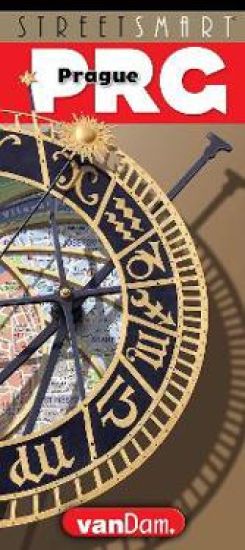
VanDam's new 2019 STREETSMART (R) Prague maps all top attractions including, major architecture, museums, churches, hotels, royal gardens, synagogues, theaters, concert halls and more at an immensely legible scale of 1:12,000 complete with 3-D building illustrations. There is a special cutaway schematic of the famed Prague Castle. Clear information design allows users to read the map from three feet away and has earned VanDam maps a place in the MoMA Collection. The map is film-laminated, accordion folded and pocket size.Coverage: Central Prague Street Map 1:24,000; Jewish Quarter & Stare Mesto Map: 1:12,000; 3D Prague Castle Map: 1:2,700; Prague Subway & Train map. Dimensions: 4 x 9 folded, 9 x 24 unfolded, fits into shirt pocket or purse.STREETSMART (R) Prague is so legible you will easily understand how all parts of the city connect. From The Golden Lane in the Castle to the Kafka Museum, the Petrin Tower to the Staranova in the Jewish Quarter, and the Wallenstein to the Kinsky Gardens. Prague, the city of 100 spires, is studded with architectural styles from Romanesque to Gothic, Baroque to Neo Classical, Art Nouveau to Cubist & Modern to Deconstructivist. Such riches attract multitudes of tourists. Try to go off season.STREETSMART (R) Prague covers all the bases from God's perspective to the most minute details. Whatever your proclivities may be this map shows you how to get there with confidence. The walk from the Castle down Nerudova named after the poet Pablo Nerudas family to Mostecka over the Charles Bridge into Star Mesto, the Gothic quarter, is filled with Central European history and counts as one of the most sensuous urban experiences in the world. Saints grace the bridge while the scent of roses transfixes the walker heading toward the Klementinum and National Archives. Next to the Old Town Hall visit the statue of Jan Hus, the famed Czech theologian who was burnt at the stake for heresy against the Catholic church. As founder of Hussitism he was a key predecessor to Protestantism and a seminal figure in the Bohemian Reformation. His execution in 1415 triggered a revolt of the Hussites against their catholic rulers defeating five papal crusades during the Hussite Wars. It is good to remember that this was a time of Papal Schism when Popes and Antipopes Gregory XII and Benedict XIII vied for power and laid claim to the Papacy. It took the Catholic Church until 1999 to apologize and express regret for the brutal murder of Hus.STREETSMART (R) Prague A 3-D illustrated cutaway schematic of the 1,100 year old Castle, now home of the Czech President, making it easy for you to understand and navigate its palaces, churches and gardens on the way to the Castle Cafe.While visiting ponder Franz Kafkas visions of K trying to enter the Castle learning that behind every gate and gatekeeper there would be multitudes more each denying him passage. A grand metaphor for 20th C alienation and bureaucracy and proof of the genius of Kafka as one of the great literary ironists. His visions of the Kafkaesque continue to wield universal power. STREETSMART (R) Prague maps all historic districts including Hradcany, the Castle District, Mala Strana, the Lesser Town; Stare Mesto, the old Gothic Quarter, Nove Mesto, the New Town, Josefov, the former Jewish ghetto and Vysehrad, an area of gardens and castle ruins. Walking is the way to explore them all. With STREETSMART (R) Prague you will experience Prague with confidence, gain instant STREETSMARTS & a memorable souvenir to boot!
Streetsmart Vancouver Map by Vandam

Streetsmart Vancouver Map by Vandam

Stephan Van Dam

Vandam
2016
kartta, viikattu
"VanDam's StreetSmart Vancouver maps all of Vancouver's attractions, neighborhoods, museums, hotels, parks, hiking trails, shorelines, and more all at an immensely legible scale of 1:7,500 complete with 3-D building illustrations. Clear information design allows you to read the map from three feet away and has earned VanDam maps a place in the MoMA Collection. The map is film-laminated, accordion folded and pocket-size.The map is laminated and easily fits into your pocket or purse. Dimensions: 4" x 9" closed, 9" x 24" open.Contents: Vancouver Region Map" 1:2,000,000 Metro Vancouver/Lower Mainland Map 1:250,000; Vancouver Street Map 1:55,000; Downtown Vancouver Detail Map: 1:20,000; Stanley Park Detail Map: 1:35,000; Coal Harbor Detail Map: 1:15,000; Richmond-Delta-Surrey Map: 1:250,000; Vancouver Burnaby Map: 1:250,000;StreetSmart Vancouveris so legible you will instantly understand how Downtown connects with Granville Island, Robson with Stanley Park, Point Grey with Kitsilano, English Bay with Yaletown, and get the overview of the Lower Mainland in context with Vancouver Island and the Gulf Islands in the Salish Sea.StreetSmart Vancouver lets you navigate Vancouver with ease and confidence. So whether you want to hike from Coal Harbor to English Bay, take the ferry from Tsawwassen to Swartz Bay on Vancouver Island, are visiting friends on Bowen Island for the weekend, experience world class Chinese cuisine in Richmond, shop at Harry Rosen -- for truly the best in menswear, visit the famed Andropology Museum at UBC or just go for a run in Stanley Park, our map covers it all.StreetSmart Vancouver No other city boasts an urban rainforest equal to Stanley Park. Our map guides you on the 8 km run along the water's edge from Coal Harbour to English Bay as well inland hikes with a stop in at the restaurants and teahouses that make this urban lung an unforgettable experience. The majesty of Douglas fir, Western red cedar and hemlock are breathtaking and hint at the riches of the rainforests on Vancouver Island and the remote Islands - Cortes for instance in Desolation Sound- where wolves run in packs and a bear may just feast at the other side of a lovely salmonberry bush.StreetSmart Vancouver maps a city unique in many ways. It may be the only city on the continent to boast three thriving Chinese communities speaking different languages and forming distinct communities: These include the descendants of Chinese immigrant workers who built the trans Canada railroads in the 1880s - 5th and 6th generation Canadians, the Hong Kong ren who left Hong Kong before the handover to China in the late 1990 - who brought class, money and sophisticated cuisine - and the nouveau rich Mandarin billionaires - the most recent arrivals - who seem to prefer orange Lamborghinis. As a result the culinary offerings stretch from $3.00 street food in Richmond - check out North America's biggest night market - to Bird Nest & Seafood Soup at Kirin for $130 on Alberni St. These days the lingua franca heard in the streets is Mandarin. Vancouver is rightfully known as the most sophisticated Asian food city in North America.StreetSmart Vancouver A local Vancouver arts impresario commented on our map cover as a perfect commentary on the most fundamental issue facing BC: who owns the land. As native people claim the entire province and absent any agreements between first Nation Peoples and the Canadian government this issue remains unresolved and central to understanding Vancouver and British Columbia. Get a StreetSmart Vancouver map and become an instant Vancouverite! "
Streetsmart Shanghai Map by Vandam

Streetsmart Shanghai Map by Vandam

Stephan Van Dam

Vandam
2017
kartta, viikattu
With the release of StreetSmart Shanghai, New Yorks award-winning mapmaker Stephan Van Dam has achieved both a personal best and a great leap forward in information design of China's most Western-influenced metropolis.This pocket-sized, gloss-laminated, accordion-fold map 4 x 9 closed (9 x 32 open) is a graphic work of art that works. It shows immensely legible cartographic information and diagrammatic 3-D illustrations and is such an advance over what has previously been available that it will be indispensable not only to visitors, but to business and recreational travelers in Shanghai for years to come.
Streetsmart NYC Midtown Map by Vandam

Streetsmart NYC Midtown Map by Vandam

Stephan Van Dam

Vandam
2025
kartta, viikattu
StreetSmart NYC Map Midtown Edition maps all top attractions including museums, major architecture, hotels, theaters, shopping destinations, Broadway theaters and the subway system for all of Manhattan at an immensely legible scale of 1:32,000, complete with 3-D building illustrations. Clear information design allows users to read the map from three feet away and has earned VanDam maps a place in the MoMA Collection. The map is laminated, pocket size and easily fits into your pocket or purse. Dimensions: 4" x 9" closed, 9" x 24" open.Contents:Manhattan Street map scale 1:32,000Midtown Manhattan map Detail scale 1:17,000Manhattan Subway MapStreetSmart NYC Map Midtown Edition is so clear and easy to understand you can navigate the city with ease.For instance: You are looking to get from your Tribeca hotel to the High Line to meet friends at the Spanish Mercado in Hudson Yards, looking for the fastest subway connection from the Lower East Side to the Hudson Theater in Midtown, negotiating the shifting grids of the West Village, looking for the right uptown exit on the FDR Drive, making sense of the Dutch Colonial Grid Downtown to find the 9/11 National Memorial before dusk for that perfect shot, or hiking from the Met through Central Park to head to the Apollo Theater Harlem for a show. The map shows you the shortest route as well as the closest bathrooms.Locals call Manhattan "the City" and refer to the boroughs of Brooklyn, The Bronx, Queens and Staten Island collectively referred to as the City of New York.StreetSmart NYC Map Midtown Edition includes a stunning dimensional detail of Midtown Manhattan with Times Square at 1:17,000 scale at its center to make you feel you are there. Also includes transit information and an address finder covering all of New York City. In fact all subway stops are shown by their respective line in context right on the street map in detail as well as on an overview map so you understand the system.Stephan Van Dam, the map designer has lived in Manhattan for over 40 years and knows the city inside out. The map is updated four times a year and the most current map available. So get StreetSmart NYC Map Midtown Edition and become an instant New Yorker.
Streetsmart NYC Downtown Map by Vandam

Streetsmart NYC Downtown Map by Vandam

Stephan Van Dam

Vandam
2025
kartta, viikattu
StreetSmart NYC Map Downtown Edition maps all top attractions including museums, major architecture, hotels, theaters, shopping destinations, ferry connections and the subway system for all of Manhattan at an immensely legible scale of 1:32,000, complete with 3-D building illustrations. Clear information design allows users to read the map from three feet away and has earned VanDam maps a place in the MoMA Collection. The map is laminated, pocket size and easily fits into your pocket or purse. Dimensions: 4 x 9 closed; 9 x 24 open.Contents: Manhattan Street map scale 1:32,000 Downtown Manhattan map Detail scale 1:17,000 Manhattan Subway MapStreetSmart NYC Map Downtown Edition is so clear and easy to understand you can navigate the city with ease. For instance: You are looking to get from your Tribeca hotel to the High Line to meet friends at the Spanish Mercado in Hudson Yards, looking for the fastest subway connection from the Lower East Side to the Hudson Theater in Midtown, negotiating the shifting grids of the West Village where W 11 and W 4 Sts intersect, looking for the right uptown exit on the FDR Drive, making sense of the Dutch Colonial Grid Downtown to find the 9/11 National Memorial before dusk for that perfect shot, or hiking from the Met through Central Park to head to the Apollo Theater in Harlem for a show. The map shows you the shortest route as well as the closest bathrooms. Locals call Manhattan the City and refer to the boroughs of Brooklyn, The Bronx, Queens and Staten Island collectively referred to as the City of New York.StreetSmart NYC Map Downtown Edition includes a stunning dimensional detail of Lower Manhattan with the 9/11 Memorial at 1:17,000 scale at its center to make you feel you are there. The map also includes transit information and an address finder covering all of New York City. All subway stops are shown by their respective line in context right on the street map as well as on an overview map so you understand the detail and the overall system.StreetSmart NYC Map Downtown Edition includes a stunning dimensional detail of Downtown Manhattan with the 9/11 National Memorial site at 1:17,000 scale at its center to help you navigate the world s only vertical city based on a 17th C Dutch grid and make you feel you in charge. The map includes transit information and an address finder covering all of New York City. Stephan Van Dam, the map designer has lived in Manhattan for over 40 years and knows the city inside out. The map is updates four times a year and the most current map available. So get StreetSmart NYC Map Downtown Edition and become an instant New Yorker.
Streetsmart NYC Top 10 Map by Vandam

Streetsmart NYC Top 10 Map by Vandam

Stephan Van Dam

Vandam
2024
kartta, viikattu
StreetSmart (R) 2025 NYC Top 10 Edition maps all top attractions including museums, major architecture, hotels, theaters, shopping destinations, Broadway theaters and the subway and ferry systems for all of Manhattan at an immensely legible scale of 1:32,000, complete with 3-D building illustrations. Clear information design allows users to read the map from three feet away and has earned VanDam maps a place in the MoMA Collection. The map is laminated, pocket size and easily fits into your pocket or purse. Dimensions: 4" x 9" closed, 9" x 36" open.Contents: Manhattan Street map scale 1:32,000 Uptown Manhattan Map 1:33,000 Manhattan Subway Map 3D Poster of Manhattan SkyscrapersStreetSmart (R) 2025 NYC Top 10 Edition is so clear and easy to understand you can navigate the city with ease. The map combines the trusted NYC Midtown Edition map with a 3D skyline poster to create a graphic souvenir you can hang on your wall.For instance: You are looking to get from your Tribeca hotel to the High Line to meet friends at the Spanish Mercado in Hudson Yards, looking for the fastest subway connection from the Lower East Side to the new Lena Horne theater in Midtown, negotiating the shifting grids of the West Village, looking for the right uptown exit on the FDR Drive, making sense of the Dutch Colonial Grid Downtown to find the 9/11 National Memorial before dusk for that perfect shot, or hiking from the Met through Central Park to head to the Apollo Theater in Harlem for a show. The map shows you the shortest route as well as the closest bathrooms. Locals call Manhattan "the City" and refer to the boroughs of Brooklyn, The Bronx, Queens and Staten Island collectively referred to as the City of New York.The 3D Skyline poster view shows you Manhattan from the Brooklyn and Queens perspectives across the East River with all buildings clearly labeled. The top 10 must does are illustrated with a cheeky description revealing the New Yorker's perspective on the vertical city.StreetSmart NYC TOP 10 Edition makes you feel you are there. Included are complete transit information with all ferry connections, and an address finder covering all of New York City. In fact all subway stops are shown by their respective line in context right on the street map in detail as well as on an overview map so you understand the system.Stephan Van Dam, the map designer has lived in Manhattan for over 40 years and knows the city inside out. The map is updated four times a year and the most current map available. So get StreetSmart (R) NYC Map Top 10 Edition and become an instant New Yorker.
Streetsmart NYC Five Boro Map by Vandam

Streetsmart NYC Five Boro Map by Vandam

Stephan Van Dam

Vandam
2024
kartta, viikattu
The newly revised 2024 edition ofStreetSmart (R) NYC Five Boro Map maps all top attractions including museums, major architecture, hotels, theaters, shopping destinations plus subway and ferry routes for all of Manhattan at an immensely legible scale of 1:32,000, complete with 3-D building illustrations. Clear information design allows users to read the map from three feet away and has earned VanDam maps a place in the MoMA Collection. The map is laminated, pocket size and easily fits into your pocket or purse. Dimensions: 4" x 9" closed, 9" x 24" open.Contents: Manhattan Street map scale 1:32,000 Five Boro NY/NJ Overview Map: 1:155,000 NYC Subway MapStreetSmart NYC Five Boro Map is so clear and easy to understand you can navigate the city with ease.For instance: You are looking to find the Ferry from 34 Street in Manhattan to Fulton Landing under the Brooklyn Bridge, to get to Yankee Stadium, or walk from your Tribeca hotel to the High Line to meet friends at the Spanish Mercado in Hudson Yards, you are searching for the fastest subway connection from the Lower East Side to Downtown Brooklyn, negotiating the shifting grids of the West Village where W 11 St intersects W4 St, looking for the right northbound exit on the FDR Drive to the South Street Seaport, trying to make sense of the Dutch Colonial Downtown streets to find the 9/11 National Memorial before dusk for that perfect shot, or hiking from the Met through Central Park to head to the Apollo Theater Harlem for a show.Locals call Manhattan "the City" and refer to the boroughs of Brooklyn, The Bronx, Queens and Staten Island collectively referred to as the City of New York. VanDam publishes separate titles to Brooklyn, The Bronx and Queens in the StreetSmart Format.StreetSmart NYC Five Boro Map includes a stunning overview map to show the Five Boros in context of the NJ/NY Metro Area with all major cultural institutions and how they connect by ferry and expressway with exit numbers.Stephan Van Dam, the map designer has lived in NYC for over 40 years and knows the city inside out. The map is updated four times a year and the most current map available. So get StreetSmart NYC Map 5 Boro Edition and become an instant New Yorker.
Shopsmart London Map by Vandam

Shopsmart London Map by Vandam

Stephan Van Dam

Vandam
2016
kartta, viikattu
VanDam's award winning London StreetSmart Top City Shops Edition maps all top attractions including museums, major architecture, hotels, theatres, the subway system for all of London, and most importantly, all of the best shopping destinations - all at an immensely legible super-scale of 1:32,000, complete with 3-D building illustrations. Clear information design allows users to read the map from three feet away and has earned VanDam maps a place in the MoMA Collection.The London StreetSmart Top City Shops Edition includes a stunning dimensional detail of all of London with over 500 of the best shops in the city ranging from clothing to home design and travel gear to vintage stores. This is the definitive list for the shopaholic in you! The ultimate in luxury, fun, and quirky shopping. Also includes transit information and a street finder covering all of London.Simplicity reigns supreme in information design to make complex cities clear and understandable. Our typography creates character and reveals the true bones of the city. VanDam uses a letter grid to identify locations on maps - no confusing and cluttering K-28 or V-34s - its just the city from A-Z. Our covers map the icons of each city and turn them into collectible graphic art. Each sleek and laminated city map package opens to 32" x 9" and then easily folds down to 4" x 9" to snuggly fit into a shirt pocket or purse. Gain instant London ShopSmarts and a sexy souvenir to boot!
Engaging North Korea: The Role of Economic Statecraft

Engaging North Korea: The Role of Economic Statecraft

Stephan Haggard; Marcus Noland

East-West Center
2011
nidottu
This monograph reviews the efficacy of economic statecraft vis- -vis North Korea, with a particular focus on the use of sanctions and inducements on the part of the United States in seeking to achieve nonproliferation and wider foreign policy objectives. Two structural constraints operate: North Korea's particularly repressive state, with a narrowing governing coalition; and the country's changing economic relations. As an empirical matter, there is little evidence that sanctions had effect, or did so only in conjunction with inducements. However, inducements did not yield significant results either, in part because of severe credibility and sequencing problems in the negotiations.
Velocity

Velocity

Stephan Martiniere

DESIGN STUDIO PRESS
2011
sidottu
Never before-seen artwork from the award-winning science-fiction and fantasy artist Stephan Martiniere Following his previous books, Quantum Dreams and Quantumscapes, Velocity is a stunning new visionary collection of sci-fi book cover paintings, commercial and film art, video game designs, and never before-seen artwork from the fantastic imagination of acclaimed artist Stephan Martiniere.
Streetsmart NYC Transit Map by Vandam

Streetsmart NYC Transit Map by Vandam

Stephan Van Dam

Vandam
2024
kartta, viikattu
StreetSmart NYC Transit Map maps the entire NYC Transit system including subways, buses, ferries, Amtrak, and the NJ Transit, LIRR, and Metro North commuter lines. The map also shows key bus connections in Brooklyn, Queens, The Bronx & Staten Island. Manhattan has its own separate bus map.The map features a Service Guide to all trains showing where and when they run local or express by borough as well as a How to Get There destination guide which tells you exactly which trains to take to the TOP 100 sights and attractions across NYC. Clear information design allows users to read the map from three feet away and has earned VanDam maps a place in the MoMA Collection. The map is laminated, pocket size and easily fits into your pocket or purse. Dimensions: 4" x 9" closed, 9" x 24" open.Contents: NYC Transit Map Manhattan Bus Map Subway Service Guide Top 100 Attractions GuideStreetSmart NYC Transit Map is so clear and easy to understand you can navigate the city with ease. Public transportation, for all its issues, is the fastest way to get around town and make your trip a success. It is also the best show in town.For instance: You are looking to find the Ferry from 34 Street in Manhattan to Fulton Landing under the Brooklyn Bridge, or get from the Metropolitan Museum to Yankee Stadium, you are searching for the fastest subway connection from the Upper East Side to Downtown Brooklyn, or meeting friends at South Ferry to connect to the Statue of Liberty or want to see the action down Fifth Avenue from the leisurely comfort of the M1 Bus after having window shopped at Bergdorf Goodman.Locals call Manhattan "the City" and refer to the boroughs of Brooklyn, The Bronx, Queens and Staten Island collectively as the City of New York. VanDam publishes separate titles to Brooklyn, The Bronx and Queens in the StreetSmart Format.StreetSmart NYC Transit Map includes a stunning overview map to show the Five Boros in context of the NJ/NY Metro Area with all major cultural institutions, sights and attractions featured and how they connect by subway, bus, ferry, train and expressway.Stephan Van Dam, the map designer has lived in NYC for over 40 years and knows the city inside out. The map is updated twice a year and the most current map available. So get StreetSmart NYC Transit Map and become an instant New Yorker.
History Mapped Washington Map by Vandam

History Mapped Washington Map by Vandam

Stephan Van Dam

Vandam
2015
kartta, viikattu
VanDam's Washington Presidential Map is both a laminated street map to downtown NYC, Boston and Philadelphia and a handy history chart of the life of President George Washington. The history map puts his personal geography into the context of his age. The street maps cover all attractions including museums, monuments with self guide tours retracing the steps of our First President.Contents: Lower Manhattan Map scale 1:8,000 Downtown Boston Map scale: 1:16,000 Downtown Philadelphia Map scale: 1:8,000 WDC Capital Region Map scale: 1:238,000 Washington Life MapThe Washington Presidential Map life map details his trajectory from British soldier, surveyor, land and slave owner, signer of the Declaration of Independence, commander in chief during the Revolution War, leader of the Constitutional convention, and First President of the new nation. A must-have for every history buff and visitor to the Washington Monument who wants to understand why we honor this man.This special North East Edition includes detailed guided walking maps of the places where Washington made history: Downtown Boston, Philadelphia, Lower Manhattan and Mount Vernon along with a Greater Washington DC Metro Map. All at an immensely legible scale with 3D buildings.VanDam's Presidential Maps make history accessible, portable and understandable to wide audiences of all ages -- from history buffs to casual Mall visitors. A 3D graphic of the Washington Monument gives insights into the construction of what is arguably the nation's most important monument. This sleek laminated map package refolds easily to 4" x 9" (from 32" x 9" open) and snuggly fits into your pocket. The smartest and most memorable souvenir around.
Streetsmart Miami Map by Vandam

Streetsmart Miami Map by Vandam

Stephan Van Dam

Vandam
2017
kartta, viikattu
StreetSmart (R) Miami maps all of Miami, Miami Beach, Coral Gables, Coconut Grove, Miami Beach and all of Dade County's attractions, neighborhoods, museums, hotels, beaches and more all at an immensely legible scale complete with 3-D building illustrations. Eminently clear information design allows users to read the map from three feet away and has earned VanDam maps a place in the MoMA Collection. The map is laminated and easily fits into your shirt pocket or purse. Dimensions: 4 x 9 closed, 9 x 24 open.Coverage includes: Miami Downtown Street Map: 1:14,000 Dade County Area Freeway Map: 1:190,000 Coral Gables & Coconut Grove Details: 1:7,500 Miami Beach Detail: 1:6,500 Wynwood Arts & Design Detail: 1:6,500StreetSmart (R) Miami includes details of Downtown Miami, Miami Beach, Coral Gables and Coconut Grove plus a Dade County Freeway map so you know immediately how all of Miami s part connect. Whether you want go gallery hopping in the Wynwood Arts District, stroll Ocean Avenue in Miami Beach, have lunch in Little Haiti, pick up a friend from the Cruise Terminal or visit the new branch of Books and Books in Coconut Grove our map will be your treasured companion. SStreetSmart (R) Miami Simplicity reigns supreme in cartographic design to make complex cities clear and understandable. Our typography creates character and reveals the true bones of this booming Caribbean metropolis. The map uses a letter grid to identify locations on maps - no confusing and cluttering K-28 or V-34s - its just the city from A-Z. Our covers map the icons of each city and turn them into collectible graphic art. Gain instant Miami StreetSmarts and a memorable souvenir to boot!