Kirjojen hintavertailu. Mukana 11 342 296 kirjaa ja 12 kauppaa.

Kirjahaku

Etsi kirjoja tekijän nimen, kirjan nimen tai ISBN:n perusteella.

1000 tulosta hakusanalla Sandra Bardwell

Croatia Sunflower Walking Guide

Croatia Sunflower Walking Guide

Sandra Bardwell

SUNFLOWER BOOKS
2020
pokkari
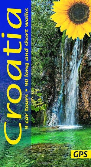
Strap on your boots and discover Croatia on foot with the Sunflower Croatia travel guide which includes 90 long and short walks. On the days when your feet may have had enough, enjoy some spectacular scenery on one of our 9 recommended car tours.
Tatra Mountains of Poland and Slovakia Sunflower Walking Guide
The go-to Tatra Mountains travel guide for discovering the best walks and car tours. Strap on your boots and discover Tatra Mountains on foot with the Sunflower Tatra Mountains travel guide. And on the days when your feet may have had enough, enjoy some spectacular scenery on one of our legendary car tours. The Sunflower Tatra Mountains guide is indispensable for hiking in the Tatra Mountains or seeing Tatra Mountains by car. For those who love mountain walks, there can be few places where hikers are better catered for than in the Polish Tatras and the Slovakian Tatras. Skilfully constructed paths make hiking in very rough terrain comparatively easy; signposting and waymarking are almost universally excellent. Hillwalkers will be in their element here, but there are often shorter, easy suggestions for the less hardy or they can create their own treks from the detailed maps in the book, which show all waymarked routes. In addition, those touring Slovakia or Poland by car will find that the tours lead to dozens of short walks and picnic spots, so that even those with little walking experience can make the most of these wonderful mountains. In each of the six national parks covered in the book you can look forward to sampling local drinks and dishes at one or more of the mountain inns. Walking in the national parks featured in this guide will undoubtedly be a very rewarding experience — the enjoyment of magnificent scenery and the excellent facilities for hikers, and perhaps also for successfully undertaking what may seem quite daunting walks in relatively high mountains. The experience can be rewarding on another level: being among people who are obviously enjoying themselves, who don’t seem to need an array of the latest outdoor fashions, and who are quietly proud of their mountain heritage. Whatever your age or ability we’ve got some glorious walks and car tours to ensure you have a memorable holiday in Tatra Mountains. Inside the Sunflower Tatra Mountains guide book you’ll find: 90 long and short walks for all ages and abilities – each walk is graded so you can easily match your ability to the level of walkTopographical walking maps – give you a clear sense of the surrounding terrainFree downloadable gps tracks – for the techiesSatnav guidance to walk starts for motorists 7 car tours and fold-out touring map – for easy reference on your tour Strolls to idyllic picnic spots – enjoy our recommendations for where to picnic along the wayTimetables for public transport – ideal if you want to link two walks or avoid hiring a car on your holidayOnline update service for the latest information Whether you tour the islands by car or explore on foot, we look forward to showing you around.
Moray Coast Trail (2 ed)

Moray Coast Trail (2 ed)

Sandra Bardwell

RUCKSACK READERS
2021
pokkari
Guidebook to the Moray Coast Trail with 44 miles of beach walking, coastal paths, quiet roads and old railways, with views across coves, beaches and skerries to the Moray Firth and North Sea. Also covers the Dava Way which covers 23 miles inland with vistas of mountain, moorland and farmland. Contains mapping at 1:40,000 and 75 colour photos.
Kerry Way (3 ed)

Kerry Way (3 ed)

Sandra Bardwell

RUCKSACK READERS
2021
pokkari
The Kerry Way runs for 130 miles through Ireland's most spectacular mountain landscapes, starting and finishing in the town of Killarney. This guidebook contains all you need to plan and enjoy your holiday: detailed route mapping; the Way in sections, with distance, terrain and refreshments; third edition fully revised after route check.
Tatra Mountains of Poland and Slovakia Sunflower Walking Guide
The go-to Tatra Mountains travel guide for discovering the best walks and car tours. Strap on your boots and discover Tatra Mountains on foot with the Sunflower Tatra Mountains travel guide. And on the days when your feet may have had enough, enjoy some spectacular scenery on one of our legendary car tours. The Sunflower Tatra Mountains guide is indispensable for hiking in the Tatra Mountains or seeing Tatra Mountains by car. For those who love mountain walks, there can be few places where hikers are better catered for than in the Polish Tatras and the Slovakian Tatras. Skilfully constructed paths make hiking in very rough terrain comparatively easy; signposting and waymarking are almost universally excellent. Whatever your age or ability we’ve got some glorious walks and car tours to ensure you have a memorable holiday in Tatra Mountains. Inside the guide you’ll find: 90 long and short walks for all ages and abilities – each walk is graded so you can easily match your ability to the level of walk Topographical walking maps – give you a clear sense of the surrounding terrain Free downloadable gps tracks – for the techies Satnav guidance to walk starts for motorists 7 car tours and fold-out touring map – for easy reference on your tour Strolls to idyllic picnic spots – enjoy our recommendations for where to picnic along the way Timetables for public transport – ideal if you want to link two walks or avoid hiring a car on your holiday Online update service for the latest information Hillwalkers will be in their element here, but there are often shorter, easy suggestions for the less hardy or they can create their own treks from the detailed maps in the book, which show all waymarked routes. In addition, those touring Slovakia or Poland by car will find that the tours lead to dozens of short walks and picnic spots, so that even those with little walking experience can make the most of these wonderful mountains. In each of the six national parks covered in the book you can look forward to sampling local drinks and dishes at one or more of the mountain inns. Walking in the national parks featured in this guide will undoubtedly be a very rewarding experience — the enjoyment of magnificent scenery and the excellent facilities for hikers, and perhaps also for successfully undertaking what may seem quite daunting walks in relatively high mountains. The experience can be rewarding on another level: being among people who are obviously enjoying themselves, who don’t seem to need an array of the latest outdoor fashions, and who are quietly proud of their mountain heritage. Whether you tour the islands by car or explore on foot, we look forward to showing you around.
Coast to Coast (2 ed)

Coast to Coast (2 ed)

Sandra Bardwell; Jacquetta Megarry

Rucksack Readers
2018
kierre
England's most popular walk runs for 184 miles (296 km) across the north of England from St Bees on the Irish Sea to Robin Hood's Bay on the North Sea. It passes through three National Parks - the Lake District, Yorkshire Dales and North York Moors - with fine scenery, welcoming pubs and plenty of accommodation. Devised by the legendary Wainwright, the Coast to Coast attracts walkers worldwide. The new edition is richly illustrated with 150 photographs, many by professional landscape photographer Karen Frenkel. There are 25 pages of colourful new mapping (scale 1:55,000) with cumulative distances, a 25-metre contour interval and points of interest marked. Each section has its own altitude profile, with details of where refreshments are available. Much detail has been added to route descriptions, in many places clarified by extra photographs with custom overlays to clarify route detail. Major route options have been added and mapped, and many updates made. The format is lightweight, robust and rainproof.
John Muir Way: A Scottish coast-to-coast route

John Muir Way: A Scottish coast-to-coast route

Sandra Bardwell; Jacquetta Megarry

RUCKSACK READERS
2020
nidottu
The John Muir Way is one of Scotland's Great Trails. It runs for 134 miles (215 km) coast-to-coast across central Scotland, from Helensburgh on the Clyde to Dunbar on the North Sea. The route is as suitable for cyclists as for walkers, and it can be completed as a coast-to-coast expedition or tackled in sections - typically ten for walkers or five for cyclists. Our 2020 lightweight edition includes the latest route updates approaching Strathblane and in Linlithgow, as well as the Three Lochs Way option leaving Helensburgh. It features mapping at 1:75,000 on 20 of its pages.The John Muir Way's appeal ranges from the Charles Rennie Mackintosh architecture of Helensburgh through the scenic grandeur of Loch Lomond, along two famous canals and past the amazing Falkirk Wheel, beside the Roman Antonine Wall, passing Linlithgow Palace, Blackness Castle and the Forth Bridges to the capital glories of Edinburgh. It goes beside the Firth of Forth to reach North Berwick, then heads inland to finish at Dunbar with its ruined castle and the John Muir birthplace.This guidebook contains all you need to plan and enjoy the John Muir Way on a bike or on foot: background on John Muir's life, the canal heritage and wildlife detailed description of the route from west to east summary of each section showing distance, terrain and food/drink stops details of visitor attractions and side-trips planning information for travel by car, train, bus or plane detailed mapping of the John Muir Way on 20 pages at 1:75,000 in full colour, with 100 photographs further route options, diversions and an unofficial shortcut.
Great Glen Way: Walk or cycle the Great Glen Way

Great Glen Way: Walk or cycle the Great Glen Way

Sandra Bardwell; Jacquetta Megarry

RUCKSACK READERS
2020
nidottu
This guidebook (fully updated in 2020) contains all you need to plan and enjoy a holiday walking or cycling along Scotland's historic Great Glen (77 miles/124 km). The Way runs between Fort William and Inverness, passing beside Scotland's highest mountain, along its historic Caledonian Canal and alongside beautiful lochs, including Loch Ness with its famous monster legend and Urquhart Castle. This sixth edition has fresh mapping at 1:38,000 on 13 pages, with detailed relief contours and colouring; on rainproof paper throughout; in full colour, with 100+ photos; visitor attractions and hills to climb including Ben Nevis; town plans of Fort William and Inverness; background on local geology, history and wildlife; summary of each section showing distance, terrain, altitude profile and food/drink stops; planning information for travel by car, train, bus or plane.This guidebook contains all you need to plan and enjoy the Great Glen Way - on foot or on a bike: detailed mapping on 13 pages at 1:38,000 hill and mountain side-trips including Ben Nevis background on canal heritage, clan history and wildlife detailed description for each section walked from Fort William to Inverness summaries showing distance, terrain, food/drink stops and altitude profile planning information for walkers and cyclists town plans of Fort William and Inverness in full colour, with 100+ photos, many of them new rucksack-friendly and on rainproof paper.
Fife Coastal Path (2 ed)

Fife Coastal Path (2 ed)

Sandra Bardwell; Jacquetta Megarry

RUCKSACK READERS
2022
pokkari
This route follows the Fife coastline for 117 mi (187 km). Starting near the famous Forth bridges, it heads beside the Firth of Forth to the fishing villages of Fife's East Neuk. Following the coastline, it passes through St Andrews, golf capital of the world, and ends at Newburgh on the unspoiled Firth of Tay. This edition has many route updates.
Dingle Way (4 ed)

Dingle Way (4 ed)

Sandra Bardwell; Jacquetta Megarry

RUCKSACK READERS
2023
nidottu
The Dingle Way runs for 114 miles (183 km) around the beautiful Dingle Peninsula. It starts and finishes in Tralee, accessible by train or bus from Dublin and from Kerry Airport. The complete walk takes eight days, but it can easily be shortened. The Dingle Way follows country lanes, quiet roads and cliff-top paths, punctuated by long stretches of glorious beach walking. It offers spectacular seascapes and mountain views. The peninsula is rich in wildlife, archaeology and charming Irish pubs. This guidebook was fully revised for 2023 with route updates, improved mapping and additional Gaelic place names. It contains all you need to plan and enjoy your holiday on the Dingle Way: the Way in sections, with summaries of distance, terrain and where to find food and drink; concise background on prehistory, heritage and wildlife; information about climbing Mount Eagle and Mount Brandon; a special feature on the Blasket Islands; planning information for travel by car, train, bus or plane; detailed mapping of the Dingle Way on 16 pages (scale 1:55,000); in full colour, with 75 photographs; and printed on rainproof paper throughout.
Kintyre Way (4 ed)

Kintyre Way (4 ed)

Sandra Bardwell; Jacquetta Megarry

RUCKSACK READERS
2023
nidottu
This fully waymarked trail runs for 101 miles/162 km southward from the beautiful natural harbour of Tarbert to Macrihanish, near the Mull of Kintyre. Criss-crossing the entire peninsula, you pass castles, abbeys and prehistoric remains, sometimes walking along rugged coastline, sometimes high on forestry tracks with glorious views over Arran, the Firth of Clyde and towards Ireland. You will enjoy many wildlife sightings in this peaceful area, famous as Scotland only "mainland island". Since it opened (2006) the route has changed in places. The 2023 edition of this essential guidebook contains all you need to plan and enjoy your holiday: 11 pages with mapping showing the whole route (1:70,000); the Way step-by-step, with summaries of distance, terrain and refreshment stops; habitats and wildlife; whisky-making in Kintyre; side-trip to the island of Gigha; and planning information for travel by car, ferry, bus and plane. The book is printed on rainproof paper throughout, and has over 90 colour photographs.
John Muir Way (3 ed)

John Muir Way (3 ed)

Sandra Bardwell; Jacquetta Megarry

RUCKSACK READERS
2023
nidottu
The John Muir Way is one of Scotland’s Great Trails. It runs for 134 miles (215 km) coast-to-coast across central Scotland, from Helensburgh on the Clyde to Dunbar on the North Sea. The route is as suitable for cyclists as for walkers, and it can be tackled as a coast-to-coast expedition or in sections – typically ten for walkers or five for cyclists. Our all-new 2023 third edition includes the latest route updates and features improved mapping with mileage markers along the route and a km grid. The mapping is at 1:75,000 and appears on 20 of its pages. It contains new material and despite having more pages is lighter and more pocketable than the previous edition thanks to perfect binding. It has many fresh photos and the new cover features the Antonine Wall from Bar Hill Fort. The John Muir Way’s appeal ranges from the Charles Rennie Mackintosh architecture of Helensburgh through the scenic grandeur of Loch Lomond, along two famous canals and past the amazing Falkirk Wheel, beside the Roman Antonine Wall, passing Linlithgow Palace, Blackness Castle and the Forth Bridges to the capital glories of Edinburgh. It goes beside the Firth of Forth to reach North Berwick, then heads inland to finish at Dunbar with its ruined castle and the John Muir birthplace.
Speyside Way (3 ed)

Speyside Way (3 ed)

Jacquetta Megarry; Sandra Bardwell

RUCKSACK READERS
2021
pokkari
The Speyside Way runs for 85 miles from the fishing port of Buckie to Newtonmore in the Cairngorms National Park. This edition has large-scale mapping at 1:42,500, and plans of villages en route. It contains all you need to enjoy your walk with detailed directions, distance, terrain and refreshments. With 103 colour photos it makes a fine souvenir.
Great Glen Way (7th ed)

Great Glen Way (7th ed)

Jacquetta Megarry; Sandra Bardwell

RUCKSACK READERS
2024
nidottu
This guidebook (fully updated in 2024) contains all you need to plan and enjoy a holiday walking or cycling along Scotland's historic Great Glen (77 miles/124 km). The Way runs between Fort William and Inverness, passing beside Scotland's highest mountain, along its historic Caledonian Canal and alongside beautiful lochs, including Loch Ness with its famous monster legend and Urquhart Castle. This seventh edition covers all route options including the newly opened Abriachan section of High Route as well as details of the route changes that apply during 2024 and 2025 because of the closure of Loch Oichside and the High Route beyond Fort Augustus. Here is all you need to plan and enjoy the Great Glen Way – on foot or on a bike: detailed mapping on 13 pages at 1:38,000 with relief contours and colouringhill and mountain side-trips including Ben Nevisbackground on canal heritage, clan history and wildlifedetailed description for each section with points of interest and mileage referencessummaries showing distance, terrain, food/drink stops and altitude profileplanning information for walkers and cyclists, with travel to/from the routetown plans of Fort William and Invernessin full colour, with 100+ photosrucksack-friendly and on rainproof paper throughout.
Great Glen Way: Walk or cycle the Great Glen

Great Glen Way: Walk or cycle the Great Glen

Jacquetta Megarry; Sandra Bardwell

RUCKSACK READERS
2024
nidottu
The Great Glen Way is one of Scotland's Great Trails and offers a superb experience for both walkers and cyclists. The Way runs for 77 miles (124 km) along Scotland's Great Glen between Fort William and Inverness. It follows the scenic Caledonian Canal and runs beside four of the Highlands' loveliest lochs - including Loch Ness, famous for its monster legend and for Urquhart Castle.The route has been enhanced with several High Route options, most recently the 2024 Abriachan High Route taking walkers to a new high point at 434 m/1425 ft. The new edition covers this option and shows it in mapping.This edition was revised in late April 2024 and covers several important route updates for 2024-25: the Invergarry link route is mandatory until Loch Oichside reopens in 2025, the Fort Augustus to Invermoriston High Route is closed until summer 2024 and the approach to Inverness has changed around Craig Dunain. The book is in our slim pocket-friendly format, with perfect binding (glued and sewn) and still on rainproof paper.This guidebook contains all you need to plan and enjoy the Great Glen Way - on foot or on a bike: detailed mapping on 13 pages at 1:38,000hill and mountain side-trips including Ben Nevisbackground on canal heritage, clan history and wildlifedetailed description for each section walked from Fort William to Invernesssummaries showing distance, terrain, food/drink stops and altitude profileplanning information for walkers and cycliststown plans of Fort William and Invernessin full colour, with 100+ photos, many of them newrucksack-friendly and on rainproof paper.
Wicklow Way

Wicklow Way

Jacquetta Megarry; Sandra Bardwell

RUCKSACK READERS
2025
nidottu
The Wicklow Way is Ireland's first and most popular Waymarked Way, running between Marlay Park (Dublin) and Clonegal, 81 miles (130 km) to the south. It offers varied and scenic walking on the flanks of the Wicklow mountains with loughs, rivers and historic remains. Much of the route lies over 1600 feet (500 metres) giving glorious views, and lower sections run through forests and farmland, over a mixture of tracks, roads and pathways rich in wildlife. This guidebook was updated in 2025 and contains all you need to plan and enjoy your holiday: detailed mapping showing the route and options (1:35,000); rainproof paper throughout; the Way in sections, with summaries of distance, terrain and where to find food and drink; concise background on history, geology and wildlife; an expanded 6-page feature on the monastic city of Glendalough; planning information for travel by car, train, bus or plane; in full colour, with 95 photographs.
Sandra

Sandra

David Cale

SAMUEL FRENCH LTD
2024
pokkari
In this one-woman thriller, Sandra seeks to get to the bottom of the mysterious disappearance of her closest friend, a young pianist and composer who went on a trip to Mexico and never returned. Her search for clues leads her into both a highly charged love affair and increasingly dangerous territory.Sandraasks, "How far would you go for love?"