Kirjojen hintavertailu. Mukana 12 425 767 kirjaa ja 12 kauppaa.
Kirjailija
National Geographic Maps
Kirjat ja teokset yhdessä paikassa: 328 kirjaa, julkaisuja vuosilta 2009-2026, suosituimpien joukossa Virginia. Vertaile teosten hintoja ja tarkista saatavuus suomalaisista kirjakaupoista.
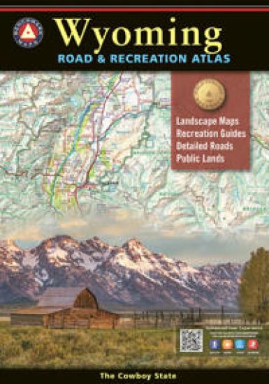
Wyoming is the heart of the American West. Experience the wild spirit of Wyoming with Benchmark's Wyoming Road & Recreation Atlas. No other map product can better portray Wyoming's rugged, sky-scraping peaks, or the vast openness where the deer and the antelope really do play! Benchmark's field-checked Landscape Maps clearly depict the terrain, and pinpoint the many backroads that crisscross the state. The Recreation Guide includes mule deer hunting units and details the many outstanding recreation destinations and opportunities within.
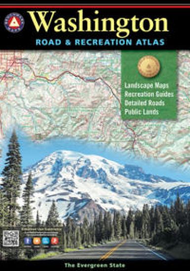
Benchmark's Washington Road & Recreation Atlas is the one guide needed to explore every corner of the Evergreen State. Field-checked Landscape Maps(TM) show complete road detail, classed by use and surface, and the updated Recreation Guide has several recreation categories organised by region including the following: Wilderness, Forest Service, State parks, State Lands, Bureau of Reclamation, Military Lands, BLM, Tribal Lands, National parks and monuments, Wilderness Areas and State game management units. Dimensions: 11 inches by 16 inches. 128 pages
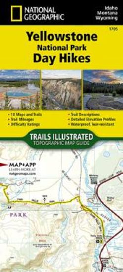
Waterproof, Tear-Resistant, Topographic Map. Yellowstone is the wild heart of America! Established in 1872, it's our first National Park and the birthplace of the National Park idea. Its 2.2 million acres contain the world's largest, most varied collection of hydrothermal features and provide sanctuary for many rare and exquisite animals. However, for me the true splendor of Yellowstone lies in its diversity. In addition to magnificent geysers and plentiful wildlife, this vast wilderness is blessed with countless sparkling clear alpine lakes and over 100 major waterfalls. Add to this, rugged mountain peaks, awesome canyons, spectacular wildflowers, fascinating forest fire areas and a rich history-Yellowstone truly has something for everyone! This Yellowstone National Park Day Hikes Topographic Map Guide contains detailed maps for 18 of Yellowstone's finest day hikes, scattered across 6 regions of the park. It includes well-known hikes, together with a few off-the-beaten-path trails, s
Looking for a fun activity to reduce stress and learn geography? Well you're in luck, because the cartographers at National Geographic have adapted our World for Kids Map to a black and white outline version that you can color at home. Color the places you've been, or the ones you dream of visiting, or color the countries randomly with pastel or bold colors. Spend a few hours or a few days to color the map. By the time you're done, you'll know a lot more countries than when you started. The World Coloring map includes country flags that can all be colored along with a bonus full color letter size sheet that has all of the flags of the world you can use as a reference. The map is packaged in a two inch diamater clear plastic tube. The tube has a decorative label showing a thumbnail of the map with dimensions and other pertinent information.
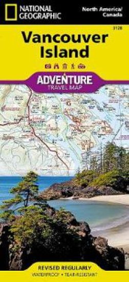
Waterproof, Tear-Resistant Travel Map.National Geographic's Vancouver Island Adventure Map provides global travelers with the perfect combination of detail and perspective in a highly functional travel tool. Cities and towns are clearly indicated and easy to find in the user-friendly index. A road network complete with distances and designations for roads, motorways, and expressways will help you find the route that's right for you. Secondary routes are also marked for those seeking to explore off the beaten path. Hundreds of points of interest and diverse and unique destinations are highlighted including national parks, nature reserves, World Heritage sites, archeological sites, ski areas, hot springs, beaches, museums, and more. The south side of the print map shows Victoria the capital of British Columbia, Pacific Rim National Park Reserve, and the costal town of Nanaimo. The northern half of the printed map covers the much more remote part of the island. There are many large prot
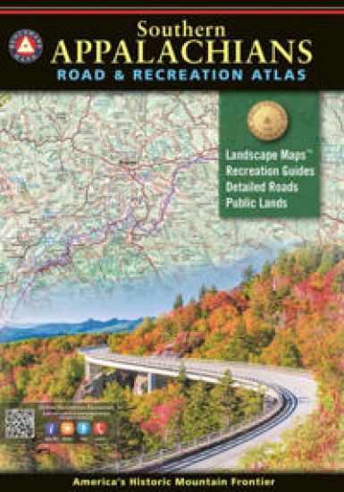
For the last 25 years, Benchmark Maps has been mapping the American West Our award winning series of Road Recreation Atlases, with thoroughly researched recreation guides and field checked Landscape Maps TM have become the go to map product for state road travel and exploration. For the new decade, we brought our focused approach to the wealth of terrain and public lands spread across several states in the southeastern United States. Let our Southern Appalachians Road & Recreation Atlas help you plan and execute your next adventure in America's historic mountain frontier.
The new National Geographic Benchmark Recreation Atlases are an ideal recreation resource complete with accurate, detailed topographic maps. They contain a wealth of robust travel information, including campground locations, state park maps, sports and activity destinations, museums, hunting and fishing information, historic sites and even climate details. Every feature is clearly labelled, field-checked and verified, and everything is organised for convenience and intuitive ease-of-use. The books feature a double laminated cover to prevent wear and tear.
Waterproof, Tear-Resistant, Topographic Map.The Haute Route-aka the High Route or Mountaineers' Route-traverses the French and Swiss Alps. It was conceived as a summer mountaineering route in the mid-nineteenth century by members of the English Alpine Club. Though originally called 'The High-Level Route' by members of the Alpine Club, in 1911, a group first successfully established a winter route from Bourg St. Pierre to Zermatt on skis and afterwards the name of the route was translated into French. As a result of their success, the French term stuck, and the journey gained a reputation amid skiers and ski mountaineers as a classic must-do winter/spring tour. There is also a non-technical Walker's Haute Route that has gained in popularity and become a classic in and of itself. This Topographic Map Guide outlines two different variations of the Haute Route from Chamonix, France to Zermatt, Switzerland: one for hikers and one for skiers. The northernmost route or, Walker's Route, depic
Waterproof, Tear-Resistant, Topographic Maps. Thrust skyward by Earth's forces between 40 and 70 million years ago, then sculpted by three glacial episodes, the Rocky Mountains are 'new' in geologic terms, and form one of the world's longest ranges-stretching almost unbroken from Alaska to below the nation's southern border. This two title Map Pack Bundle helps explorers of all levels see everything this astounding park has to offer. The map pack includes an overview map that shows the entire park as well as a Day Hikes map guide. With this combination of maps visitors can feel comfortable planning a trip to a park with options for everyone, from multi-day backpack trips to short hikes near Trail Ridge Road. The Rocky Moutain National Park Day Hikes Topographic Map Guide includes sixteen diverse hikes for all hiking enthusiasts, from the easy, 4.7 mile long Cub Lake Trail to the strenuous, 8.4 mile long Chasm Lake Trail that brings hikers to base of the 14,259 foot Longs Peak. Each hi
Waterproof, Tear-Resistant, Topographic Map. First protected in 1864 and designated as the third national park in 1890, Yosemite is home to countless natural icons including Yosemite Falls, the world's fifth tallest waterfall; El Capitan, one of the largest exposed monoliths of granite in the world; and Yosemite Valley and the Mariposa Grove of Giant Sequoias, which were the first scenic natural areas set aside by a national government for public benefit and appreciation. With so many spectacular historical, scientific and scenic resources and recreational opportunities that include backpacking, hiking, world-class climbing, fishing, camping and numerous winter pursuits, Yosemite has something for everyone. The Yosemite National Park Day Hikes Topographic Map Guide includes eighteen diverse hikes for all hiking enthusiasts, from the easy, 2.8 mile long Hetch Hetchy Valley Overlook to the strenuous, 14.7 mile long Laurel Lake Trail with 3,900' of elevation gain. Each hike has a detaile
Waterproof, Tear-Resistant, Topographic Maps. Yosemite National Park has some of the most stunning landscapes in the world. This two title Map Pack Bundle helps explorers of all levels see everything this astounding park has to offer. The map pack includes an overview map that shows the entire park as well as a Day Hikes map guide. With this combination of maps visitors can feel comfortable planning a trip to a park with options for everyone, from multi-day backpack trips to short hikes in Yosemite Valley. The Yosemite National Park Day Hikes Topographic Map Guide includes eighteen diverse hikes for all hiking enthusiasts, from the easy, 2.8 mile long Hetch Hetchy Valley Overlook to the strenuous, 14.7 mile long Laurel Lake Trail with 3,900' of elevation gain. Each hike has a detailed map, a trail profile visualizing the changes in elevation, and a short summary of the interesting features encountered along the trip. Buy the Map Pack and save 15%! The Yosemite National Park and Day H
Waterproof, Tear-Resistant, Topographic Map. Winter Park delivers adventures of all kinds to those who visit. From Denver, it's the closest major mountain town-just 67 miles away-and this year-round destination tucked in the high country of the Rockies offers wild and remote opportunities. A paradise for outdoor enthusiasts of all types, Winter Park boasts dozens of trails, ideal for hiking and mountain biking that are easily accessible from town. Here visitors can truly experience the best of the Rockies: magnificent views of towering mountain peaks, exciting camping, hiking, biking, and a plethora of winter recreation including alpine skiing, cross country skiing, and riding snowmobiles. With so many outdoor recreation options, visitors to Winter Park have an enviable problem, where should they start? This map is a combination of a standard trail map on the front with a helpful guide on the back that has a selection of recommended hikes, from the easy 3.2 mile Fraser River Trail to
Waterproof, Tear-Resistant, Topographic Maps. The Appalachian Trail (AT) Map Pack Bundle of Vermont, New Hampshire includes two Topographic Map Guides that cover the AT in these two very distinct states. The landscape of Vermont is a variety of wooded mountains, forests of white pine and paper birch, and rolling terrain dotted by fields and pastures. To the north and east, the AT crosses short, steep hills and overgrown farmlands that characterize the Connecticut River valley. Farther south is the rugged and rocky high country of the Green Mountains. The AT through New Hampshire is considered one of the more challenging sections of the trail, with long stretches above tree line and the possibility for rapid temperature change and snow any month of the year. But despite its difficulty, the trail offers some of the most spectacular scenery in New England as it leaves the Connecticut River valley to traverse the beautifully rugged White Mountains, a highlight of the AT. Each AT Topograp
Waterproof, Tear-Resistant, Topographic Maps. The Appalachian Trail (AT) Map Pack Bundle of Pennsylvania includes two Topographic Map Guides that cover the entire AT in the Keystone State. The map follows the ridges of the Appalachian Mountains and weaves in and out of suburbia. This section of trail, which is notoriously rocky, is rich in history with traces of early industry-charcoal furnaces, railroads, and coal mining. Each AT Topographic Map Guide includes detailed topographic maps at a detail of 1 inch = 1 mile. Each page is centered on the A.T. and overlaps with the adjacent pages so there is little chance of getting lost. Along the bottom of each page is a trail profile that shows the distance between shelters, camping areas, and trail access points. The map and trail profile provide a step by step visual guide to hiking the trail, mile by rugged mile. The Topographic Map Guide is built for all levels of hiking enthusiasts, from the day tripper to the multi month 'thru-hiker'.
Waterproof, Tear-Resistant, Topographic Maps. The Appalachian Trail (AT) Map Pack Bundle of Georgia, North Carolina, and Tennessee includes two Topographic Map Guides that cover the AT from the southern terminus at Springer Mountain to Damasus on the Tennessee-Virginia state line. The southernmost section of the AT offers some of most physically challenging, but rewarding hiking along the entire trail including a more than 70 mile long section that passes through Great Smoky Mountains National Park. Each AT Topographic Map Guide includes detailed topographic maps at a scale of 1 inch = 1 mile. Each page is centered on the A.T. and overlaps with the adjacent pages so there is little chance of getting lost. Along the bottom of each page is a trail profile that shows the distance between shelters, camping areas, and trail access points. The map and trail profile provide a step by step visual guide to hiking the trail, mile by rugged mile. The Topographic Map Guide is built for all levels
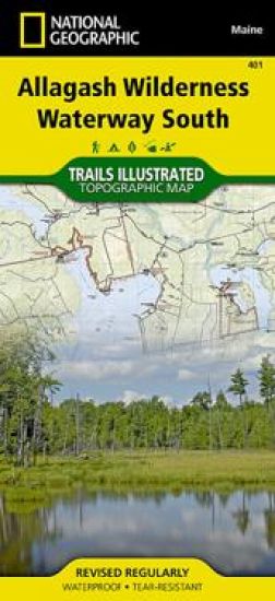
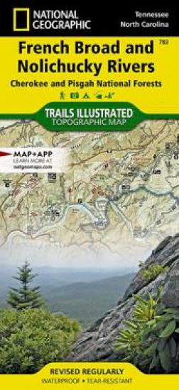
National Geographic's Trails Illustrated Maps are the most detailed and up-to-date topographic recreation maps available for US National Parks, National Forests and other popular outdoor recreation areas. A necessity for exploring the outdoors, each map is printed on waterproof, tear-resistant material. They also contain key safety and contact information, GPS and compass coordinates, Leave No Trace ethical guidelines and hundreds of points-of-interest, including scenic viewpoints, campgrounds, boat launches, swimming areas, marine sanctuaries and wildlife refuges.
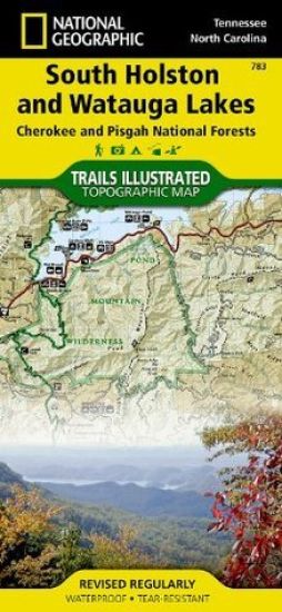
National Geographic's Trails Illustrated Maps are the most detailed and up-to-date topographic recreation maps available for US National Parks, National Forests and other popular outdoor recreation areas. A necessity for exploring the outdoors, each map is printed on waterproof, tear-resistant material. They also contain key safety and contact information, GPS and compass coordinates, Leave No Trace ethical guidelines and hundreds of points-of-interest, including scenic viewpoints, campgrounds, boat launches, swimming areas, marine sanctuaries and wildlife refuges.
National Geographic's Trails Illustrated Maps are the most detailed and up-to-date topographic recreation maps available for US National Parks, National Forests and other popular outdoor recreation areas. A necessity for exploring the outdoors, each map is printed on waterproof, tear-resistant material. They also contain key safety and contact information, GPS and compass coordinates, Leave No Trace ethical guidelines and hundreds of points-of-interest, including scenic viewpoints, campgrounds, boat launches, swimming areas, marine sanctuaries and wildlife refuges.
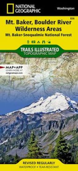
National Geographic's Trails Illustrated Maps are the most detailed and up-to-date topographic recreation maps available for US National Parks, National Forests and other popular outdoor recreation areas. A necessity for exploring the outdoors, each map is printed on waterproof, tear-resistant material. They also contain key safety and contact information, GPS and compass coordinates, Leave No Trace ethical guidelines and hundreds of points-of-interest, including scenic viewpoints, campgrounds, boat launches, swimming areas, marine sanctuaries and wildlife refuges.
National Geographic's Trails Illustrated Maps are the most detailed and up-to-date topographic recreation maps available for US National Parks, National Forests and other popular outdoor recreation areas. A necessity for exploring the outdoors, each map is printed on waterproof, tear-resistant material. They also contain key safety and contact information, GPS and compass coordinates, Leave No Trace ethical guidelines and hundreds of points-of-interest, including scenic viewpoints, campgrounds, boat launches, swimming areas, marine sanctuaries and wildlife refuges.

![World Coloring Map [tubed]](/covers/9781566958523.jpg)
![Haute Route Map [chamonix To Zermatt]](/covers/9781566958103.jpg)
![Rocky Mountain National Park Map & Day Hikes [map Pack Bundle]](/covers/9781566958356.jpg)

![Yosemite National Park Map & Day Hikes [map Pack Bundle]](/covers/9781566958363.jpg)
![Winter Park Map [local Trails]](/covers/9781566958196.jpg)
![Appalachian Trail: Vermont, New Hampshire [map Pack Bundle]](/covers/9781566958417.jpg)
![Appalachian Trail: Pennsylvania [map Pack Bundle]](/covers/9781566958394.jpg)
![Appalachian Trail: Georgia, North Carolina, Tennessee [map Pack Bundle]](/covers/9781566958370.jpg)