Kirjojen hintavertailu. Mukana 12 390 323 kirjaa ja 12 kauppaa.

Kirjailija

Stephan Van Dam

Kirjat ja teokset yhdessä paikassa: 39 kirjaa, julkaisuja vuosilta 2015-2025, suosituimpien joukossa Streetsmart Shanghai Map by Vandam. Vertaile teosten hintoja ja tarkista saatavuus suomalaisista kirjakaupoista.

39 kirjaa

Kirjojen julkaisuhaarukka 2015-2025.

Streetsmart NYC Midtown Map by Vandam

Streetsmart NYC Midtown Map by Vandam

Stephan Van Dam

Vandam
2025
kartta, viikattu
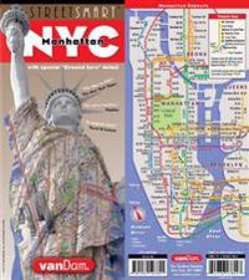
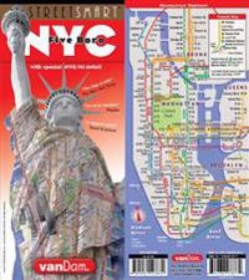
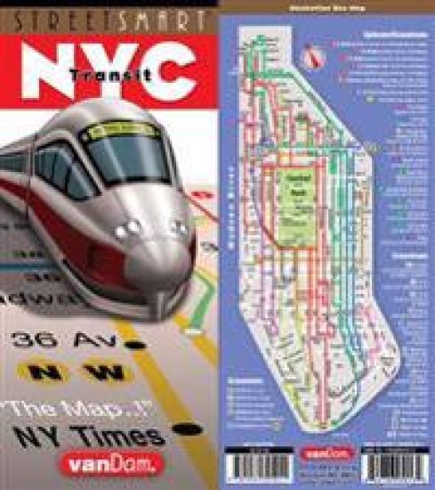
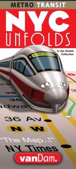
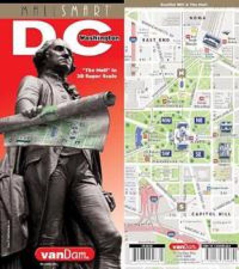
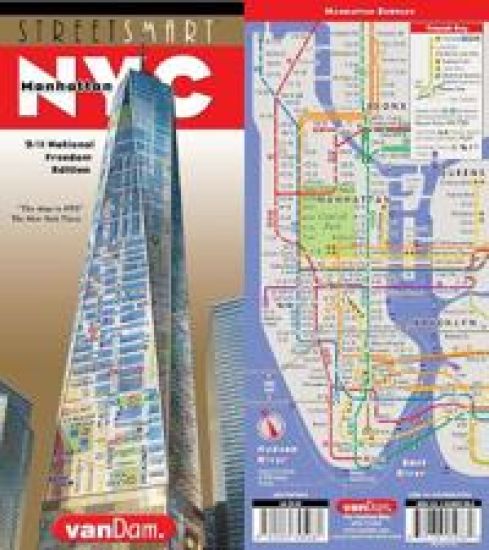
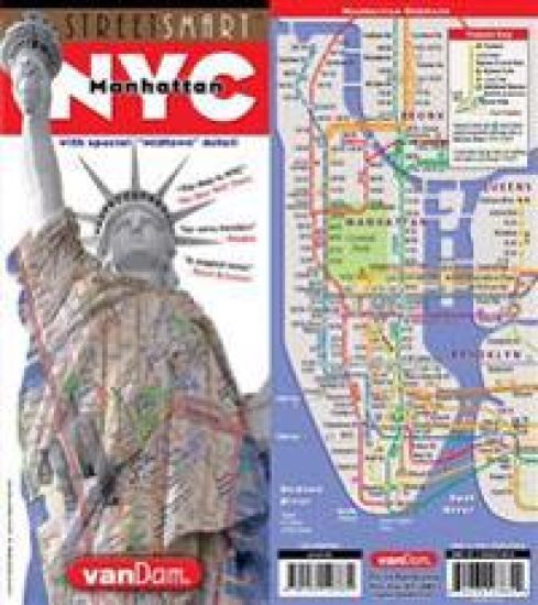
StreetSmart NYC Map Midtown Edition maps all top attractions including museums, major architecture, hotels, theaters, shopping destinations, Broadway theaters and the subway system for all of Manhattan at an immensely legible scale of 1:32,000, complete with 3-D building illustrations. Clear information design allows users to read the map from three feet away and has earned VanDam maps a place in the MoMA Collection. The map is laminated, pocket size and easily fits into your pocket or purse. Dimensions: 4" x 9" closed, 9" x 24" open.Contents:Manhattan Street map scale 1:32,000Midtown Manhattan map Detail scale 1:17,000Manhattan Subway MapStreetSmart NYC Map Midtown Edition is so clear and easy to understand you can navigate the city with ease.For instance: You are looking to get from your Tribeca hotel to the High Line to meet friends at the Spanish Mercado in Hudson Yards, looking for the fastest subway connection from the Lower East Side to the Hudson Theater in Midtown, negotiating the shifting grids of the West Village, looking for the right uptown exit on the FDR Drive, making sense of the Dutch Colonial Grid Downtown to find the 9/11 National Memorial before dusk for that perfect shot, or hiking from the Met through Central Park to head to the Apollo Theater Harlem for a show. The map shows you the shortest route as well as the closest bathrooms.Locals call Manhattan "the City" and refer to the boroughs of Brooklyn, The Bronx, Queens and Staten Island collectively referred to as the City of New York.StreetSmart NYC Map Midtown Edition includes a stunning dimensional detail of Midtown Manhattan with Times Square at 1:17,000 scale at its center to make you feel you are there. Also includes transit information and an address finder covering all of New York City. In fact all subway stops are shown by their respective line in context right on the street map in detail as well as on an overview map so you understand the system.Stephan Van Dam, the map designer has lived in Manhattan for over 40 years and knows the city inside out. The map is updated four times a year and the most current map available. So get StreetSmart NYC Map Midtown Edition and become an instant New Yorker.
Streetsmart Dublin Map by Vandam

Streetsmart Dublin Map by Vandam

Stephan Van Dam

Vandam
2025
kartta, viikattu
VanDam's StreetSmart Dublin maps all top attractions including museums, major architecture, castles, hotels, theaters, pubs and parks at an immensely legible scale, complete with 3-D building illustrations. Clear information design allows users to read the map from three feet away and has earned VanDam maps a place in the MoMA Collection. The map is film-laminated, accordion folded and pocket size.Coverage: Metro Dublin Area Map 1:135,000 Central Dublin Street Map: 1:17,000 Dublin Downtown & Temple Bar Detail Map: 1:11,000 Dublin DART and LUAS Suburban Rail Map Dimensions: 4 x 9 folded, 9 x 24 unfolded, fits into shirt pocket or purse.StreetSmart Dublin includes a stunning dimensional detail of Downtown Dublin so you can move gracefully from Dublin Castle to Temple Bar and Trinity College and beyond. Dublin's rise as a tech hub makes it one of the most dynamic cities as Ireland boasts the youngest population in all of Europe. The Celtic Tiger, as Dublin is known, is headquarters for tech giants from Apple to Google, and Twitter to ZooDigital as well as for start-ups which have transformed the old Grand Canal Docks into the new Silicon Docks. Citibank's annual list of most competitive cities in the world ranked Dublin as the city with the best "human capital."Historically, the city is cleft in half by the river Liffey. While the northern part has housed the working classes the southern part has been the domain of bankers. The tech boom has blurred these lines to create riches for all. On the south side you will visit Temple Bar with its profusion of pubs, shops, and restaurants. Trinity College presides over Grafton Street the city's fanciest shopping venue. On the North side stop by the Writers Museum & Irish Writers Centre to luxuriate in the poetic aspects of Irish culture. For weekend getaways use the Metro Dublin map to discover castles & cairns in the Greater Dublin area.StreetSmart Dublin Simplicity reigns supreme in information design to make complex cities clear and understandable. Our typography creates character and reveals the true bones of the city. VanDam uses a letter grid to identify locations on maps - no confusing and cluttering K-28 or V-34s - its just the city from A-Z. Our covers map the icons of each city and turn them into collectible graphic art. Each sleek and laminated city map package opens to 32" x 9" and then easily folds down to 4" x 9" to snuggly fit into a shirt pocket or purse. Gain instant Dublin StreetSmarts and a memorable souvenir to boot!
Streetsmart Madrid Map by Vandam

Streetsmart Madrid Map by Vandam

Stephan Van Dam

Vandam
2025
kartta, viikattu
VanDam's award-winning Madrid StreetSmart maps all top attractions including museums, major architecture, hotels, and shopping destinations - all at an immensely legible super-scale of 1:2,400, complete with 3-D building illustrations. Clear information design allows users to read the map from three feet away and has earned VanDam maps a place in the MoMA Collection.Madrid StreetSmart includes a stunning dimensional detail of Centro, Parque del Buen Retiro, Ciudad Jardin-Salamanca, and Cuatro Caminos-Trafalgar. Edition includes a Madrid Transit map.Simplicity reigns supreme in information design to make complex cities clear and understandable. Our typography creates character and reveals the true bones of the city. VanDam uses a letter grid to identify locations on maps - no confusing and cluttering K-28 or V-34s - its just the city from A-Z. Our covers map the icons of each city and turn them into collectible graphic art. Each sleek and laminated city map package opens to 24" x 9" and then easily folds down to 4" x 9" to snuggly fit into a shirt pocket or purse. Gain instant Madrilleno StreetSmarts and a sexy souvenir to boot!
Streetsmart Florence Map by Vandam
VanDam's newly revised 2025 StreetSmart (R) Florence maps all top attractions including museums, architecture, galleries, historic sites, hotels, palazzos and more at an immensely legible scale of 1:6,500, complete with 3-D building illustrations. The map is so legible you can read it from three feet away. Its information design has earned VanDam maps a place in the MoMA Collection. The map is film-laminated and easily fits into shirt pocket or purse. Dimensions: 9" x 4" closed, 9" by 24" open.Coverage: Florence Street Map 1:10,500; Florence Centro Storico Map 1: 6,500; Ponte Vecchio, Uffizi Map 1:3,000; Florence Metropolitan Area Map 1:85,000Florence is a walkers' paradise. StreetSmart (R) Florence makes sure you get around town on foot with confidence and ease. We select the most memorable walks and direct you in six self-guided tours:The Renaissance Walk" leads you from Brunelleschi's Duomo to the Uffizi galleries along Via dei Calzaiuoli through Piazza della Repubblica and on to Piazza della Signoria, the very heart of the city. To explore the Uffizi follow the 3D detail on the back cover to see whose work is on which floor.To explore the bohemian quarter across the Arno River with boutiques and antiques shopping (Via Maggio) let the "Oltrarno Walk" guide you to Santo Spirito Osteria Santo Spirito serves truffle and cheese gnocchi right next door and Palazzo Pitti a vast complex of renaissance architecture fit for a Medici but built for a Pitti leads to the marvelous Boboli Gardens, not to be missed before returning you to the famed Ponte Vecchio built in 1345 in the Italian medieval vernacular style.The "David Walk" takes you to the San Marco neighborhood right into Galleria dell'Accademia to ponder and admire the abs, buttocks and curves of ,who is arguably humanity's sexiest naked man: David by Michelangelo. If the head and right hand look slightly out of proportion that's intentional. Reflect on the process of how to turn marble into translucent skin and become art over a Campari tonic on the terrace at Loggiato di Serviti, the romantic hotel next door. Within a block in either direction are the Archeology Museum, the Museo San Marco, and within a minute the Opificio delle Pietre Dure, a workshop and global leader in the field of art restoration.For spectacular and memorable sunset views from the hills overlooking the Arno and the City choose The "Piazzale Michelangelo Walk." It ascends from Santa Felicita up Costa di San Giorgio passing Galileo's House, the Bardini complex museum, studio and gardens through Porta San Giorgio and continues along the city wall on Belvedere to Via del Monte alle Croci. Make a right and head up to Piazzale Michelangelo. Handily, there is a restroom before you scale the heights. Return to the city on Viale Michelangelino to Piazza Ferucci for a change of scenery.The "Centro Storico Walk" takes you on a stroll from the frescoes of Chiesa di Santa Maria Novella down Via Brunelleschi crossing Piazza della Repubblica with stops at Palazzo Strozzi, Mercato Nouvo and the Ponte Vecchio as its finale.The "Medici and Markets Walk" wends its way from Piazza dell'Unita Italiana through the San Lorenzo neighborhood to its eponymous church, the Medici chapel and the Laurentian library into bustling Mercato Centrale. Grab lunch in the food court upstairs savoring Florentine delicacies such as lampredotto, porchetta and trippa. Finish it off with luscious gelato artigianale: Fig and/or basilico (basil) and pinolo (pine nut) are local favorites.
Streetsmart NYC Downtown Map by Vandam

Streetsmart NYC Downtown Map by Vandam

Stephan Van Dam

Vandam
2025
kartta, viikattu
StreetSmart NYC Map Downtown Edition maps all top attractions including museums, major architecture, hotels, theaters, shopping destinations, ferry connections and the subway system for all of Manhattan at an immensely legible scale of 1:32,000, complete with 3-D building illustrations. Clear information design allows users to read the map from three feet away and has earned VanDam maps a place in the MoMA Collection. The map is laminated, pocket size and easily fits into your pocket or purse. Dimensions: 4 x 9 closed; 9 x 24 open.Contents: Manhattan Street map scale 1:32,000 Downtown Manhattan map Detail scale 1:17,000 Manhattan Subway MapStreetSmart NYC Map Downtown Edition is so clear and easy to understand you can navigate the city with ease. For instance: You are looking to get from your Tribeca hotel to the High Line to meet friends at the Spanish Mercado in Hudson Yards, looking for the fastest subway connection from the Lower East Side to the Hudson Theater in Midtown, negotiating the shifting grids of the West Village where W 11 and W 4 Sts intersect, looking for the right uptown exit on the FDR Drive, making sense of the Dutch Colonial Grid Downtown to find the 9/11 National Memorial before dusk for that perfect shot, or hiking from the Met through Central Park to head to the Apollo Theater in Harlem for a show. The map shows you the shortest route as well as the closest bathrooms. Locals call Manhattan the City and refer to the boroughs of Brooklyn, The Bronx, Queens and Staten Island collectively referred to as the City of New York.StreetSmart NYC Map Downtown Edition includes a stunning dimensional detail of Lower Manhattan with the 9/11 Memorial at 1:17,000 scale at its center to make you feel you are there. The map also includes transit information and an address finder covering all of New York City. All subway stops are shown by their respective line in context right on the street map as well as on an overview map so you understand the detail and the overall system.StreetSmart NYC Map Downtown Edition includes a stunning dimensional detail of Downtown Manhattan with the 9/11 National Memorial site at 1:17,000 scale at its center to help you navigate the world s only vertical city based on a 17th C Dutch grid and make you feel you in charge. The map includes transit information and an address finder covering all of New York City. Stephan Van Dam, the map designer has lived in Manhattan for over 40 years and knows the city inside out. The map is updates four times a year and the most current map available. So get StreetSmart NYC Map Downtown Edition and become an instant New Yorker.
Streetsmart Paris Map by Vandam

Streetsmart Paris Map by Vandam

Stephan Van Dam

Vandam
2024
kartta, viikattu
The new 2024 StreetSmart (R) Paris maps all top attractions including museums, monuments, hotels, major architecture, shopping and more all at a highly legible scale of 1:12,500, complete with 3-D building illustrations. Clear information design allows users to read the map from three feet away and has earned VanDam maps a place in the MoMA Collection. The map is film-laminated, waterproof and easily fits into pocket or purse.Contents: Paris Street Map 1:12,500; Paris Overview map: 1:200,000; Paris Metro Map; Dimensions: 4 x 36 (10 cm x 91 cm) open, 4 x 9 (10 cm x 22 cm) closed.StreetSmart (R) Paris is so legible you will understand how the Champs des Elysees connects with Champs de Mars, Bois de Boulogne with Belleville, Catacombs with Cimetiere Pere Lachaise, Les Halles with La Defense, Quartier Latin with Luxemburg, Montmartre with Montparnasse, Marais with St Germain des Pres and Canal St Martin. StreetSmart Paris Paris is unique in many ways. It was Emperor Napoleon III who in 1853 commissioned Baron Georges-Eugene Haussmann to reinvent the city with new infrastructure and Grand Boulevards cutting through blighted medieval neighborhoods to create the new City of Light. This map shows the plan with Metro stops by line right on the street map. So you can easily understand the local detail in context and see the entire system in an overview map for God's perspective.Paris is the city of the Flaneur the ambivalent drifter who wanders the citys Grand Boulevards looking for chance encounters of the literary and erotic kind. Park benches are said to be spaced in 500 m intervals to encourage Flaneurie.Walter Benjamin, the culture critic, elevated this gastronomy of the eye into the academy channeling the poetry of Baudelaire. The Situationist movement of the 1950s added the idea of psycho-geography an exploration of the city through drifting described as a toy box full of playful, inventive strategies for exploring cities to create new realities through maps.Paris is saturated with excellent museum exhibits this winter: Check out the new Bourse de Commerce which houses the Pinault Collection. StreetSmart Paris Every Sunday from 9 am until 1:30 pm, the air on Boulevard Raspail, between the Rue Cherche-Midi and Rue de Rennes, fills with the tantalizing smell of sauteing onions. It is the onion galettes - shredded onion, potato and cheese (2.50 euros)- frying at one of the dozens of stands at the Marche Biologique Raspail. This organic market has been a neighborhood jewel for 26 years. A new wave of affordable comfort food dining options with three-course meals for 20 Euros in 30 minutes is taking Paris by storm. It is a revival of the Bouillon working-class restaurants that thrived during the 19th C and an affirmation of Gallic identity.Here are six establishments worth trying: Bouillon Julien at 16 Faubourg St Denis, Bouillon Pigalle, 22 Blvd de Clichy, Aux Bons Crus, 54 Rue Godefroy Cavaignac, Buffet, 8 rue de la Main d Or, Le Cadoret, 1 rue Pradier, Cafe du Coin, 9 Rue Camille Desmoulins. StreetSmart Paris map is updated twice a year and most current. Its film lamination is extra durable and will last for your next trip. Simplicity reigns supreme to make complex cities clear and understandable.Get a StreetSmart Paris map and gain instant Paris StreetSmarts.
Streetsmart NYC Five Boro Map by Vandam

Streetsmart NYC Five Boro Map by Vandam

Stephan Van Dam

Vandam
2024
kartta, viikattu
The newly revised 2024 edition ofStreetSmart (R) NYC Five Boro Map maps all top attractions including museums, major architecture, hotels, theaters, shopping destinations plus subway and ferry routes for all of Manhattan at an immensely legible scale of 1:32,000, complete with 3-D building illustrations. Clear information design allows users to read the map from three feet away and has earned VanDam maps a place in the MoMA Collection. The map is laminated, pocket size and easily fits into your pocket or purse. Dimensions: 4" x 9" closed, 9" x 24" open.Contents: Manhattan Street map scale 1:32,000 Five Boro NY/NJ Overview Map: 1:155,000 NYC Subway MapStreetSmart NYC Five Boro Map is so clear and easy to understand you can navigate the city with ease.For instance: You are looking to find the Ferry from 34 Street in Manhattan to Fulton Landing under the Brooklyn Bridge, to get to Yankee Stadium, or walk from your Tribeca hotel to the High Line to meet friends at the Spanish Mercado in Hudson Yards, you are searching for the fastest subway connection from the Lower East Side to Downtown Brooklyn, negotiating the shifting grids of the West Village where W 11 St intersects W4 St, looking for the right northbound exit on the FDR Drive to the South Street Seaport, trying to make sense of the Dutch Colonial Downtown streets to find the 9/11 National Memorial before dusk for that perfect shot, or hiking from the Met through Central Park to head to the Apollo Theater Harlem for a show.Locals call Manhattan "the City" and refer to the boroughs of Brooklyn, The Bronx, Queens and Staten Island collectively referred to as the City of New York. VanDam publishes separate titles to Brooklyn, The Bronx and Queens in the StreetSmart Format.StreetSmart NYC Five Boro Map includes a stunning overview map to show the Five Boros in context of the NJ/NY Metro Area with all major cultural institutions and how they connect by ferry and expressway with exit numbers.Stephan Van Dam, the map designer has lived in NYC for over 40 years and knows the city inside out. The map is updated four times a year and the most current map available. So get StreetSmart NYC Map 5 Boro Edition and become an instant New Yorker.
Streetsmart NYC Transit Map by Vandam

Streetsmart NYC Transit Map by Vandam

Stephan Van Dam

Vandam
2024
kartta, viikattu
StreetSmart NYC Transit Map maps the entire NYC Transit system including subways, buses, ferries, Amtrak, and the NJ Transit, LIRR, and Metro North commuter lines. The map also shows key bus connections in Brooklyn, Queens, The Bronx & Staten Island. Manhattan has its own separate bus map.The map features a Service Guide to all trains showing where and when they run local or express by borough as well as a How to Get There destination guide which tells you exactly which trains to take to the TOP 100 sights and attractions across NYC. Clear information design allows users to read the map from three feet away and has earned VanDam maps a place in the MoMA Collection. The map is laminated, pocket size and easily fits into your pocket or purse. Dimensions: 4" x 9" closed, 9" x 24" open.Contents: NYC Transit Map Manhattan Bus Map Subway Service Guide Top 100 Attractions GuideStreetSmart NYC Transit Map is so clear and easy to understand you can navigate the city with ease. Public transportation, for all its issues, is the fastest way to get around town and make your trip a success. It is also the best show in town.For instance: You are looking to find the Ferry from 34 Street in Manhattan to Fulton Landing under the Brooklyn Bridge, or get from the Metropolitan Museum to Yankee Stadium, you are searching for the fastest subway connection from the Upper East Side to Downtown Brooklyn, or meeting friends at South Ferry to connect to the Statue of Liberty or want to see the action down Fifth Avenue from the leisurely comfort of the M1 Bus after having window shopped at Bergdorf Goodman.Locals call Manhattan "the City" and refer to the boroughs of Brooklyn, The Bronx, Queens and Staten Island collectively as the City of New York. VanDam publishes separate titles to Brooklyn, The Bronx and Queens in the StreetSmart Format.StreetSmart NYC Transit Map includes a stunning overview map to show the Five Boros in context of the NJ/NY Metro Area with all major cultural institutions, sights and attractions featured and how they connect by subway, bus, ferry, train and expressway.Stephan Van Dam, the map designer has lived in NYC for over 40 years and knows the city inside out. The map is updated twice a year and the most current map available. So get StreetSmart NYC Transit Map and become an instant New Yorker.
Streetsmart NYC Top 10 Map by Vandam

Streetsmart NYC Top 10 Map by Vandam

Stephan Van Dam

Vandam
2024
kartta, viikattu
StreetSmart (R) 2025 NYC Top 10 Edition maps all top attractions including museums, major architecture, hotels, theaters, shopping destinations, Broadway theaters and the subway and ferry systems for all of Manhattan at an immensely legible scale of 1:32,000, complete with 3-D building illustrations. Clear information design allows users to read the map from three feet away and has earned VanDam maps a place in the MoMA Collection. The map is laminated, pocket size and easily fits into your pocket or purse. Dimensions: 4" x 9" closed, 9" x 36" open.Contents: Manhattan Street map scale 1:32,000 Uptown Manhattan Map 1:33,000 Manhattan Subway Map 3D Poster of Manhattan SkyscrapersStreetSmart (R) 2025 NYC Top 10 Edition is so clear and easy to understand you can navigate the city with ease. The map combines the trusted NYC Midtown Edition map with a 3D skyline poster to create a graphic souvenir you can hang on your wall.For instance: You are looking to get from your Tribeca hotel to the High Line to meet friends at the Spanish Mercado in Hudson Yards, looking for the fastest subway connection from the Lower East Side to the new Lena Horne theater in Midtown, negotiating the shifting grids of the West Village, looking for the right uptown exit on the FDR Drive, making sense of the Dutch Colonial Grid Downtown to find the 9/11 National Memorial before dusk for that perfect shot, or hiking from the Met through Central Park to head to the Apollo Theater in Harlem for a show. The map shows you the shortest route as well as the closest bathrooms. Locals call Manhattan "the City" and refer to the boroughs of Brooklyn, The Bronx, Queens and Staten Island collectively referred to as the City of New York.The 3D Skyline poster view shows you Manhattan from the Brooklyn and Queens perspectives across the East River with all buildings clearly labeled. The top 10 must does are illustrated with a cheeky description revealing the New Yorker's perspective on the vertical city.StreetSmart NYC TOP 10 Edition makes you feel you are there. Included are complete transit information with all ferry connections, and an address finder covering all of New York City. In fact all subway stops are shown by their respective line in context right on the street map in detail as well as on an overview map so you understand the system.Stephan Van Dam, the map designer has lived in Manhattan for over 40 years and knows the city inside out. The map is updated four times a year and the most current map available. So get StreetSmart (R) NYC Map Top 10 Edition and become an instant New Yorker.
Streetsmart Barcelona Map by Vandam

Streetsmart Barcelona Map by Vandam

Stephan Van Dam

Vandam
2024
kartta, viikattu
VanDam's 2025 StreetSmart Barcelona maps all top attractions including, museums, churches, city beaches, hotels, theaters, major architecture and more at an immensely legible scale of 1:19,000 complete with a 3-D building illustrations. Clear information design allows users to read the map from three feet away and has earned VanDam maps a place in the MoMA Collection. The map is film-laminated, accordion folded and pocket size.Coverage: Regional Barcelona Map 1:63,000; Barcelona Street Map: 1:19,000; Ciutat Vela (Raval, Barri Gotic, La Ribera) Detail Map 1:8,900; Barceloneta Detail Map: 1:7,700 Metro TMB Map. Dimensions: 4 x 9 folded, 9 x 32 unfolded, fits into shirt pocket or purse.StreetSmart Barcelona is so legible you will easily understand how all parts of the city connect. From La Sagrada Familia to Mont Juic, from Park Guell to Casa Mila, from Barceloneta to La Boqueria and from Barri Gotic to Tibidabo. Barcelona, the city of Gaudiesque grandeur has been a creative and design capital since Roman times. Studded with architectural treasures from Romanesque to Gothic, Baroque to Neo Classical, Art Nouveau to Modernista (La Pedrera) and Modern (Barcelona Pavillion by Mies van der Rohe) the city attracts multitudes of tourists. To avoid overtourism try to go off season.StreetSmart Barcelona covers all the bases from God's perspective to the most minute details. A stunning dimensional detail of Ciutat Vela with its neighborhoods of Barri Gotic, La Ribera, El Born and El Raval is so clearly rendered you can gracefully navigate from Mercat La Boqueria through Ramblas to the Picasso Museum and beyond. Sporting some of the grandest boulevards in Europe such as Av Diagonal Barcelona is a walkers paradise offering urban riches made even more delightful with a map that indicates tiny medieval passages just as clearly as the grand boulevards so you always know where you are.StreetSmart Barcelona allows you to get around the largest Gothic City in Europe with ease and features a self guided Modernista tour of the architecture of Gaudi and Lluis Domenech i Montaner. Stroll up Passeig de Gracia in the L'Example district to be awed by their modernist Gothic designs found nowhere else. The octagonal urban grid design of this district by the 19th C city planner Ildefons Cerda creates a unique rhythm and turns every intersection into a plaza. It also lets light and ventilation reach mid block. A brilliant design known to designers and urban planners as the L'Eixample Blocks. If you crave great furniture shopping this town is Mecca. Also, look for La Casa del Bacalao a store unique to Barcelona which sells only one thing: Cod in all guises.StreetSmart Barcelona guides you from Barri Gotic to the home of FC Barcelona, one of the top soccer clubs in the world. Its Camp Nou stadium is the temple where Messi and Suarez do their magic playing futbol total. Our TMB Transport overview map combines subways, buses, local and national trains with funicular and gondola connections. All local transit stops are marked in context by line right on all maps. This enables you to confidently take public transportation after a hot day at the beach via bus, tram and funicular from Barceloneta to cool Tibidado (1,680 feet up in the coastal range). Visit the mini cathedral of Sacrat Cor, the adjacent amusem
StreetSmart (R) USA Interstate Road Map by VanDam
StreetSmart (R) USA Interstate Map by VanDam features all the top attractions, national parks, -forests, -monuments, museums, theme parks, engineering marvels, natural treasures, and holiday destinations, PLUS individual driving guides to the top 40+ scenic routes in all 50 states from Alaska to Florida. 2024 Road Smart Edition.Dimensions: 40" x 27" open, 9" x 4" closed to fit into your pocket and glove compartment. This high-quality, eight-color map is printed on waterproof, tear resisted, synthetic Poly Art plastic stock which refolds easily without tearing and stands up to grease, weather and chemicals. A keeper.Contents: Main Continental USA map scale: 1:4,700,000; Alaska map detail 1: 23,000,000; Hawaiian Islands detail: 1: 3,500,000; Puerto Rico 1:1,100,000; USA Mileage Distances Chart, USA Milage and Distances Map.StreetSmart (R) USA Interstate Map by VanDam accurately shows all cities, points of interest, state and country boundaries, mountain ranges, and is easy to read from three feet away which has earned VanDam maps a place in the MoMA Design Collection. . VanDam is a trusted brand with superior data and information design. You will instantly understand the interstates system and how it connect with state roads and which Top 40+ Scenic Byways are close by on your cross country or weekend escape trips to catch a special scenic detour or plan a driving vacation. An essential travel tool in your car, and a beautiful piece of graphic art on your wall as a rolled poster.The USA Mileage Distance Chart makes it easy to determine and plan driving distances while the USA Mileage and Distances map relates travel time and distances for easy and reliable navigation.StreetSmart (R) USA Interstate Map by VanDam Here is a sampling of the Top 40+ Drives.Ecotopia Drive: To savor the Pacific North West with its dramatic coastal rainforests start with a feast of alder-smoked salmon at Seattle's Pike Place Market, then drive through the temperate and lush rainforests of Olympic National Park listening to the sounds of the ocean at La Push with a massage and/or overnight stop at Sol Duc Hot Springs before heading down the Oregon coast with the ocean on your right toward Northern California. Possible side trips might include the Farmland Tour and Powell's Books, the country's largest independent as you wend your way through Ecotopia to Redwoods National Park just over the Northern California state border. A once in a lifetime adventure. Total mileage: 620 (997 kms) allow 3-5 days.God's Country: Utah's Scenic Byway 12 from Panguitch to Torrey offers the most stunningly beautiful and divine landscapes anywhere on earth: Start at Zion Nat'l Park, proceed to Bryce Canyon, Grand Staircase Escalante Nat'l Mon, then Glen Canyon Nat'l Park and finish at Capitol Reef Nat'l Park, all within an easy 123 mile (197.5) km drive.The New Jersey Lighthouse Tour Seven historic lighthouses on the Jersey Shore make a memorable 129-mile trip down Rt 9. Start with the oldest (1764) at Sandy Hook & finish at victorian Cape May with swims at Diamond & Wildwood Crest beaches, plus a stop at the Boss' Stone Pony in Asbury Park.Civil Rights Trail this historic route leads you from Tuskegee (Tuskegee Airmen Nat'l Historic Site) to Montgomery (The Civil Rights Memorial Center & The Nat'l Memorial for Peace & Justice) to Birmingham (16th St Baptist Church) and on to Anniston, Alabama. A great way to memorialize Dr. King.So get the new 2024 StreetSmart (R) USA Interstate Map by VanDam to discover the magic drives only the USA can offer!
Streetsmart Venice Map by Vandam

Streetsmart Venice Map by Vandam

Stephan Van Dam

Vandam
2024
kartta, viikattu
VanDam's new 2024 StreetSmart (R) Venice maps all top attractions, churches, museums, major architecture, galleries, historic sites, hotels, palazzi, bars, restaurants, bars and more at an immensely legible scale of 1:5,500, complete with 3-D building illustrations. Clear information design allows users to read the map from three feet away and has earned VanDam maps a place in the MoMA Collection. The map is film-laminated and easily fits into shirt pocket or purse. Dimensions: 9" x 4" closed, 9" by 36" open.Coverage: Venice Street Map 1:10,500; Central Venice Detail including Castello, Cannaregio, Dorsoduro, San Marco, San Polo, Santa Croce, 1: 6,500; Venice Lagoon Area Map 1:85,000, Murano Detail: 1:19,000; Vaporetto Transportation MapVenice is a walkers' paradise. StreetSmart (R) Venice makes sure you get around town on foot and by boat with confidence and ease. We select the most memorable walks away from the tourist throngs and direct you in five self-guided tours. Here are two examples:The "Rialto Loop Walk" leads you from Piazza San Marco - just two rights and a left- to Harry's Bar through San Marco to Teatro La Fenice,the famed opera house where the premieres of the major bel canto era composers-Rossini, Bellini, Donizetti, and Verdi-were performed. It's name "The Phoenix" is testament to its stature as a performing arts theater to "rise from the ashes" three times after devastating fires in 1774, 1836 and 1996. Crossing Ponte de la Verona over Rio Adigio you arrive at Campo Manin a dreamy plaza en route to the restored 15th-century Cotarini Palace whose spiral staircase La Scala Cotarini del Bovolo starred in Orson Welles' film Othello. Around the corner is Teatro Goldini which may the perfect place to watch the Casanova Opera Pop. Passing Palazzo Bembo you arrive at the Canal Grande. Turn right to take in the buzz, history and splendor of the Rialto Bridge the oldest of the four bridges crossing the Canal Grande. Continue on via Campo San Bartolomeo and admire the art and architecture of Chiesa di San Salvador, a landmark baroque church where the great Titian Annunciation of 1563/6 sits on an altar. Enjoy the grey interior before re-entering commercial culture of the Merceria the main shopping street in Venice which leads you back into Piazza San Marco. Finish off your walk with an espresso at Caffe Florian to take in the scene.The "Zaccaria Walk" guides you from Piazza San Marco to San Zaccaria Church and back to the Palazzo Ducale. The Church is famous for its "Sacra Conversazione" altar piece by Bellini, a major forerunner of the Venetian School who tutored the masters Titian and Giorgione and dates to 1505. In 1787, Napoleon - while sacking the city of Venice - cut the altarpiece out of its frame taking it back to Paris; it was later returned. To ponder the significance of wars shuttling art from capital to capital head down toward the Riva to Bar Dandolo across Rio Vin for high tea and/or a signature cocktail. Exiting the bar turn right at the Grand Canal and look up Rio del Palazzo to view the Bridge of Sighs (Ponte dei Sospiri) which connects the Doge's Palace to the prison across the rio. Best viewed at night.To explore the sestiere of San Polo & its famed Mercato della Pescheria take the Rialto to Frari Walk on a journey from the famed fishmarket - come early - through the San Polo neighborhood to Santa Maria Gloriosa dei Frari church, a singular specimen of Franciscan Gothic architecture, and its late renaissance masterpiece: Titian's "Assumption of the Virgin.So get StreetSmart (R) Venice and become an instant Venetian.
Streetsmart Rome Map by Vandam

Streetsmart Rome Map by Vandam

Stephan Van Dam

Vandam
2024
kartta, viikattu
VanDam's newly revised 2024 StreetSmart (R) Rome maps all top attractions including hotels, top gelaterias, pizzerias & trattorias at an immensely legible scale of 1:12,500 complete with 3-D building illustrations. Clear information design allows you to read the map from three feet away and has earned VanDam maps a place in the MoMA Collection. The map is fill-laminated, accordion folded and pocket size.Coverage: Rome Center City Street Map 1:12,500; The Vatican Detail Map: 1:6,500; Rome Overview Map: 1:235,000; Greater Rome Transportation Map. Dimensions: 4 x 9 folded, 9 x 24 unfolded, fits into shirt pocket or purse.StreetSmart (R) Rome is so legible you will instantly understand how Via del Corso Rome's main artery connects Piazza Venezia with the Spanish Steps, Trastevere with the Jewish Ghetto, Vatican City with Villa Borghese and the new archeological Museo Barracco with the best gelateria Gunther Gelato in Piazza San Eustachio in Centro Storico.StreetSmart (R) Rome focuses on the urban core, the four square miles within the ancient Aurelian wall which is the part you need to know. We select the best & direct you safely in four self-guided walks: The "Centro Storico Walk" from the Piazza Navona to the Spanish Steps via Fontana di Trevi and Propaganda Av, the "Palatine Hill Walk" exploring the ruins of the imperial palaces overlooking Circus Maximus, the "Trastevere Walk" from Ponte Cestio to Santa Maria in Trastevere with top pizza options at Otaleg or a romantic Roman dinner at Zia.The "Jewish Ghetto Walk" takes you from Isola Tiberina to the Sinagoga, the center of the old Jewish neighborhood, on to bakeries offering fruit bread w/ marzipan to Palazzo Mattei. Artichokes reign supreme in Rome especially from February through May & the twice grilled Jewish version called "Carciofi alla giudia" is a must try at Nonna Beta (16) Via del Portico d'Ottavia. From God's perspective to the most minute detail our map will be a treasured companion during your stay and make it easy to understand the Eternal City.A special 3D illustration of Citta del Vaticano Vatican City details all the sights in a country of 100 acres small enough to fit into NYC's Central Park with a global following of 1.3 billion, this is the third largest state in the world. Starting from the obelisk in the Piazza di San Pietro into the basilica through Bernini's portico, down the central nave to Charlemagne's Coronation site, St Peter's statue to the Main Altar under Bernini's Canopy and above St Peter's Tomb, check out the Throne of St Peter in the apse before the entrance up to Michelangelo's dome (450 feet above), this is the greatest church (basilica) in Christendom. For quick entry into the Vatican museums the G spot of religious art patronage get your pass on-line to avoid lengthy waiting in-line. Imagine the Vatican museums as a giant "dumbbell" moving from ancient history (Egyptian, Greco-Roman & Etruscan) through a long corridor with magnificent maps, statues & tapestries to the Renaissance revival portion (Raphael Rooms to the Last Judgement Wall in the Sistine Chapel). Then walk through the history of painting from the Middle Ages to the Baroque in the Pinacoteca viewing Giotto, Leonardo da Vinci, Raphael, il Perugino and Caravaggio. It's all here. For modern art and contemporary performance there's MACRO, MATTATOIO, MAXXI & MONK. This 2024 edition features a new overview map to show you exactly where to hike or bike on the "Via Appia Antica" to visit its 12 major sites catacombs and churches along the wa. ySo get StreetSmart (R) Rome to become an instant Roman(x)..!.
Wdc Pop-Up Map by Vandam

Wdc Pop-Up Map by Vandam

Stephan Van Dam

Vandam
2024
kartta, viikattu
Washington DC Pop-Upmaps all top attractions including museums, major architecture, hotels, theaters, shopping destinations, and the Metro system for all of Washington DC at an immensely legible scale of 1:32,000, complete with 3-D building illustrations. Clear information design allows users to read the map from three feet away and has earned VanDam maps a place in the MoMA Collection. The map is laminated, pocket size and unfolds to 12 times its original size, then refolds itself by closing the covers. The map easily fits into your pocket or purse. Dimensions: 3.75" x 6" closed, 8.5" x 11" open per section.Coverage: Mall Map: 1:9,500 Washington DC Street Map 1:16,000 Beltway Map: 1:238,000; Capital MetroTransit Map. Washington DC Pop-Up Map is so legible you will instantly understand the National Mall and how it connects to other parts of the District and Old Town Alexandria.You get God's perspective on Monument City as well as the minute details. This 18th Century city grid with grand diagonal avenues designed by Pierre L'Enfant is a metaphor for the division of power in the Republic. A right triangle with Pennsylvania Avenue as hypotenuse and grand connector between the Executive (White House) and the Legislature (Congress) with the Judiciary (Supreme Court) backing up to Congress on Capitol Hill. The Washington Monument describes the triangle's Western point and serves as your compass needle to navigate the Capital.Washington DC Pop-Up Map includes a stunning dimensional Mall detail of the central city from Arlington National Cemetery through Foggy Bottom, Federal Triangle, Judiciary Square, Penn Quarter, Chinatown, Downtown, the East End and Capitol Hill. Restrooms and concessions are clearly marked. Separate Beltway and Metro DC maps insure you have everything you need for a successful trip. While politics in the Capital may be petty and divisive, the riches of art, science and culture offered in its museums almost all of them free are generous, conciliatory and un-equalled anywhere else.The hot ticket in town remains the African American Museum of History and Culture. Its bronze colored corona architecture boldly breaks the mold of the mostly white neo-classicist structures on the Mall and offers an intriguing perspective on American history. On the West Mall history is made manifest in the placement of the MLK Memorial where Dr. King stares down Jefferson with Lincoln's backing.Washington DC Pop-Up's map scale of 1:6,000 makes you feel you are there with 3D buildings illustrations as your compass. All Metro stops are marked by their respective line in context right on the main map and on a separate subway overview so you know both the local details and understand the larger system.Stephan Van Dam, the map designer and publisher has mapped the Capital for the Smithsonian, The National Gallery and the National Park Service. We also publish a series of Presidential History Maps Lincoln, Jefferson and Washington as well as WDC Pop up Map.Washington DC Pop-Up Maps are updated twice a year and are more current than any other map available. So get the 2024 Pop up and become an instant Washingtonian!
StreetSmart (R)Tokyo Map by VanDam
VanDam's new 2023 StreetSmart (R) Tokyo maps all top attractions including museums, shrines, palaces, temples, hotels, markets and more at an immensely legible scale complete with 3-D building illustrations & nine distinct walking tours. Clear information design allows users to read the map from three feet away and has earned VanDam maps a place in the MoMA Collection. The map is film-laminated, accordion folded and pocket size.Coverage: Tokyo Area Map 1:50,000; Marunouchi /Ginza Map 1:15,000; Shibuya/Harajuku/Akasaka/Aoyama /Roppongi/Azabu Map 1:15,000; Shinjuku Map 1:12,000; Ueno Map 1:8,000; Asakusa Map 1:7,400; Tokyo Metro Transit Map (Bilingual)StreetSmart (R) Tokyo makes the world's most populous metropolis 38 million inhabitants and $2 trillion in economic activity, accessible and easy to navigate. Detailed block by block maps cover all major districts including: Shinjuku-ku, Shibuya-ku, Ginza, Harajuku, Akasaka, Aoyama, Roppongi, Azabu, Marunouchi, Ueno and Asakusa.There is also a Metropolitan Overview Map with transit lines to put it all in context and make your visit a success.StreetSmart (R) Tokyo maps nine self-guided tours from the Imperial Palace's East Gardens Walk through the glittering Ginza shopping district Walk to the Tsukiji fish market, the world's largest. Then board the JR Yamamote train to Shinjuku to visit the free observatories atop the Tokyo Metropolitan Government Towers then explore Shinjuku's saucy cabarets and energizing night life. You will walk with confidence from Shibuya crossing (2,500 people at each light change) via hip Cat Street Shops toOmotesando for high-end design shopping amidst jaw dropping modern architecture to the forested tranquility of the Meji shrine. A History walk guides you from a 1,378 year old Buddhist shrine Senso-ji shrine in Asakusa across the Sumida river to the mind bending views from the futuristic Tokyo Skytree. Whether you want to visit the grand collection of art museums in Ueno, or explore the Roppongi Art Triangle before a musical experience at the Tokyo Blue Note jazz club StreetSmart (R) Tokyo helps you move around with confidence.StreetSmart (R) Tokyo Given the many options Tokyo has to offer this map helps you make the right choices and clearly shows the best public transportation connections right on the map with all exits clearly marked. There is also a bilingual Transit Map Overview to see how all the parts connect.Tokyo's address system is unique. Few streets are named. Building addresses are not related to streets names and may not be sequential. Addresses are based on city wards (which can measure several sq miles), the chome or subdistrict, and the banchi or block which vary in size and may contain 3-5 buildings. Here is how to find your way: Look for Chome names on telephone or street light poles and the corners of major buildings. A typical address may read as follows: 1 4 8 Roppongi, Minato-ku, Tokyo or at times like this: 4 8 Roppongi, 1 chome. The 1 is the chome, 4 is the block number, and 8 the building number. Roppongi is the district, Minatu-Ku is the city ward and Tokyo is the city.Tokyo arguably has the best public transportation systems in the world. It is without doubt the fastest way to get around town. Subway stations and cars are well marked in both English and Japanese. There are 12 subway lines criss-crossing the city and one can transfer freely between them. There are also four private Toei lines with their own fare system all shown clearly in the system map with the local detail right on the street map. They key is finding the right exit which are clearly marked on all maps. So get StreetSmart Tokyo to travel confidently and gain instant Tokyo StreetSmarts.
NYC Transit Unfolds Pop-Up Map by Vandam

NYC Transit Unfolds Pop-Up Map by Vandam

Stephan Van Dam

Vandam
2023
kartta, viikattu
VanDam's new2024 NYC Transit UNFOLDS (R) Pop-up maps the entire MTA Subway system. The Pop-up map unfolds to 6 times times its original size, then refolds automatically when the covers are closed. Easily fits into shirt pocket or purse. Clear information design allows users to read the map from three feet away and has earned VanDam Maps a place in the MoMA Collection.CONTENTS: Entire MTA Subway system, Manhattan Subway detail map; Midtown Manhattan detail map from Lexington to 9th Ave and Central Park to the new Moynihan Train shed.A How to get there by subway, bus and ferry guidegives directions to the Top 100 NYC attractions. A detailed Manhattan Subway map at the flick of a finger puts you in total control to understand the details of individual stations and the system at large. Gain instant NYC TransitSmarts and a sexy souvenir to boot!
London Pop-Up Map by Vandam

London Pop-Up Map by Vandam

Stephan Van Dam

Vandam
2023
kartta, viikattu
VanDam's London UNFOLDS Pop-Up maps all top attractions including museums, monuments, architecture, hotels, shops and theaters plus the Tube at an immensely legible scale of 1:20,000 complete with 3-D building illustrations. Clear information design allows users to read the map from three feet away and has earned VanDam maps a place in the MoMA Collection. The map is laminated, pocket size and unfolds to 12 times its original size, then refolds itself when closing the covers. The map easily fits into your pocket or purse.Coverage: London City Street Map 1:20,000; The West End Map: 1:14,000; Theatreland Detail Map: 1:9,000 Central London & Docklands Map London Tube Map Dimensions: 3.75 x 6 folded, 8.5 x 11 unfolded per section.London UNFOLDS Pop-Up is so legible you will instantly understand how The City connects with Covent Garden, Hampstead Heath with Hoxton, Kensington with Knightsbridge and Tate Modern with the Tower of London. From God's perspective to the most minute alleys our map will be a treasured companion during your stay.Despite a 2,000 year history the City never had an urban masterplan. Londontown is an agglomeration of medieval villages which form the heart of the metropolis we all love. Turn a corner and new worlds unfold. London is unique in many ways. It is the only city to boast an entire street designated for men's fashion needs: Jermyn Street in St James's. Discerning gents buy their fragrances at Geo F Trumper, dine at Wilton's, get their bespoke shirts at Turnbull & Asser, shoes at John Lobb and accessories at Dunhill. After window shopping, cut through Piccadilly Arcade for High Tea and cuke sandwiches at Fortnum & Mason's 4th floor Diamond Jubilee Salon. One of the great pleasures of being here is hearing the English language flexed. In theatres and on the street where locals take the time to chat about any subject. British cheer remains the lingua franca despite Brexit.Among our favorite walks: from The Mile Square City, now the Financial Centre, to St Paul's crossing Millennium Bridge to Tate Modern with grand views back over the Thames. Knightsbridge and Belgravia are among the toniest neighborhoods. Start at Harrods, the mother of all department stores, to see the latest fashions and taste from the mind-boggling selections of hams on the ground floor, then walk off the calories in Hyde Park with a visit to Serpentine Gallery for cutting edge art and design. Or start the day sipping cappuccino at the London Review of Books store on Bury Pl, then take the 55 bus from Bloomsbury to the Sunday Flower Market on Columbia Rd in East London with lunch at Rochelle Canteen on Arnold Circus. Stroll down Brick Lane to check out the latest East End fashions. Whatever excursions you plan our laminated pocket sized map will make you travel with confidence and help create lasting memories.London UNFOLDS Pop-Up includes a Central London Map plus a stunning dimensional detail of The West End so you can do historic walks and easily manage the maze of Soho, Theatreland, Piccadilly, Trafalgar Sq and St James's. The map scale of 1:14,000 makes you feel you are there with 3D buildings illustrations as your compass. All Tube stops are marked by their respective line in context right on the main map and on a separate Tube overview so you know both the local details and understand the larger system.London UNFOLDS Pop-Up maps are most current. Its film lamination is extra durable and will last for your next trip. Simplicity reigns to make complex cities clear and understandable. Each map opens to 36" x 9" and then folds down to 4"x 9". Gain instant London StreetSmarts.
Mallsmart Washington DC Map by Vandam

Mallsmart Washington DC Map by Vandam

Stephan Van Dam

Vandam
2023
kartta, viikattu
VanDam's 2025 MallSmart (R) WASHINGTON DC Edition maps all top attractions including museums, memorials, monuments, major architecture, hotels, the Smithsonian, government and association buildings, the National Mall and the Metro system for all of Washington DC at an immensely legible super-scale of 1:9,500 complete with 3-D building illustrations. Clear information design allows you to read the map from three feet away and has earned VanDam maps a place in the MoMA Collection. The map is film-laminated, accordion folded and pocket size. Coverage: Mall Map: 1:9,500 Washington DC Street Map 1:16,000 Beltway Map: 1:238,000 Alexandria Map Detail: 1:16,000 Adams Morgan Map Detail:1:16,000 Howard University Map Detail: 1:16,000 Capital Metro Transit Map. Dimensions: 4 x 9 folded, 9 x 24 unfolded, fits into shirt pocket or purse.2025 MallSmart (R) WASHINGTON DC is so legible you will instantly understand the National Mall and how it connects to other parts of the District and Old Town Alexandria. You get God's perspective on Monument City as well as the minute details. This 18th Century city grid with grand diagonal avenues designed by Pierre L'Enfant is a metaphor for the division of power in the Republic. A right triangle with Pennsylvania Avenue as hypotenuse and grand connector between the Executive (White House) and the Legislature (Congress) with the Judiciary (Supreme Court) backing up to Congress on Capitol Hill. The Washington Monument describes the triangle's Western point and serves as your compass needle to navigate the Capital.2025 MallSmart (R) WASHINGTON DC includes a stunning dimensional Mall detail of the central city from Arlington National Cemetery through Foggy Bottom, Federal Triangle, Judiciary Square, Penn Quarter, Chinatown, Downtown, the East End and Capitol Hill. Restrooms and concessions are clearly marked. Separate Beltway and Metro DC maps insure you have everything you need for a successful trip. While politics in the Capital may be petty and divisive, the riches of art, science and culture offered in its museums almost all of them free are generous, conciliatory and unequaled anywhere else. The hot ticket in town is the new African American Museum of History and Culture. Its bronze colored corona architecture boldly breaks the mold of the mostly white neo-classicist structures on the Mall and offers an intriguing perspective on American history. On the West Mall history is made manifest in the placement of the MLK Memorial where Dr. King stares down Jefferson with Lincoln's backing.2025 MallSmart (R) WASHINGTON DC map scale of 1:9,500 makes you feel you are there with 3D buildings illustrations as your compass. All Metro stops are marked by their respective line in context right on the main map and on a separate subway overview so you know both the local details and understand the larger system. Stephan Van Dam, the map designer and publisher has mapped the Capital for the Smithsonian, The National Gallery and the National Park Service. We also publish a series of Presidential History Maps Lincoln, Jefferson and Washington as well as WDC Pop up Map.2025 MallSmart (R) WASHINGTON DC maps are updated at least twice a year and are more current than any other map available. So get MallSmart and become an instant Washingtonian.
StreetSmart (R) Iceland Map by VanDam
VanDam's new StreetSmart (R) Iceland maps all of the island's cultural and natural treasures at an immensely legible scale complete with stunning 3D relief maps of the entire country. Clear information design has earned VanDam maps a place in the MoMA Collection. The map is laminated, pocket-size, durable, and easy-to-read and fold. Dimensions: 9 x 4 closed, 9 x 36 open.Coverage: Iceland country driving map: 1:1,900,000 Reykjavik city walking map: 1:23,000StreetSmart (R) Iceland is so legible you can read it from three feet away and will instantly understand how the capital of Reykjavik connects with the Golden Circle, the South Coast with Vanjoekull National Park, and the Westman Islands with the Godafoss waterfall. You will know where to bird on the Reykanes Peninsula, hike in thorsmoerk Valley, whale watch at the Arctic Circle and where to break for lunch on Ring Road Drive through the East Fjords.This map is your visual guide and essential reference to the geothermal baths, geysers, glaciers, ice caves, fissures, volcanoes and the 4WD driving routes Iceland is famous for.StreetSmart (R) Iceland is designed to be both a planning tool and a durable road guide. The map gives you an overview to easily choose between the 6-day Ring Road trip spanning 800 miles, and three 10-12 hour day trips from Reykjavik to the Golden Circle, the South Coast, and West Iceland. Tested Route Guides describe highlights of each drive by day and hour and provide the necessary logistics to make sure you catch the 20:45 ferry into the sunset for an overnight stay on the Westman Islands.StreetSmart (R) Iceland map is waterproof, pocket-size and folds easily so you do not run the risk of covering the driver's sight lines when turning it over plus you avoid searching in vain for your missing wifi and roaming signals.So whether you want to cave dive at thingvellir National Park or simply marvel at the Mid-Ocean Ridge breaking the earth's surface to reveal how the Eurasian and North American plates push apart at Almannagja fissure, the geologic wonder that is Iceland - volcanoes covered by glaciers spilling into lagoons surrounded by black sand beaches lining the Arctic Ocean guarded by thousands of puffins - Iceland comes alive on this map.For a simple cultural overnight visit the map shows recommended walks, restaurants and shops in Downtown Reykjavik. If you are looking for The Phallus Museum, a dance performance at Idno Cultural House or you just want to find the restaurant serving the best local lamb we will get you there with confidence and ease. Hint: Apotek.Naming names: The map names all features in English so you can instantly tell that Solheimajoekull is a glacier, Gullfoss a waterfall and Hella a volcano. Clearly legible icons show where to bird, cave dive, swim, hike, sauna and whale watch around Iceland.StreetSmart (R) Iceland makes it all clear and understandable. For instance, you are on the scenic route 435 to thingvellir National Park via the Mosfellsheidi Valley when suddenly white steam rises from geothermal pipes embedded in black volcanic rocks covered with thick emerald moss carpets: An otherworldly sight. This map will give you the shortest and most scenic route to get there and back with confidence. Even though you may have a tour lined up and only need to follow the person in front of you this map will give you an insight into the unparalleled geologic, tectonic and volcanic riches that are Iceland.StreetSmart (R) Iceland makes it easy and you an instant Icelander.
Streetsmart NYC 9/11 Edition Map by Vandam

Streetsmart NYC 9/11 Edition Map by Vandam

Stephan Van Dam

Vandam
2019
kartta, viikattu
StreetSmart NYC Map 9/11 Edition maps all top attractions including museums, major architecture, hotels, theaters, shopping destinations, Broadway theaters and the subway system for all of Manhattan at an immensely legible scale of 1:32,000, complete with 3-D building illustrations. Clear information design allows users to read the map from three feet away and has earned VanDam maps a place in the MoMA Collection. The map is laminated, pocket size and easily fits into your pocket or purse. Dimensions: 4" x 9" closed; 9" x 24 open.Contents:Manhattan Street map scale 1:32,0009/11 Memorial Detail Map scale 1:7,000Manhattan Subway MapStreetSmart NYC Map 9/11 Edition is so clear and easy to understand so you can navigate the city with ease.For instance: You are looking to get from your Tribeca hotel to the High Line to meet friends at the Spanish Mercado in Hudson Yards, looking for the fastest subway connection from the Lower East Side to the Hudson Theater in Midtown, negotiating the shifting grids of the West Village, looking for the right uptown exit on the FDR Drive, making sense of the Dutch Colonial Grid Downtown to find the 9/11 National Memorial before dusk for that perfect shot, or hiking from the Met through Central Park to head to the Apollo Theater Harlem for a show. The map shows you the shortest route as well as the closest bathrooms. Also includes complete transit information and an address finder covering all of New York City.Locals call Manhattan "the City" and refer to the boroughs of Brooklyn, The Bronx, Queens and Staten Island collectively referred to as the City of New York.StreetSmart NYC Map 9/11 Edition The NYC StreetSmart 9/11 Edition includes a stunning dimensional detail of Lower Manhattan with the 9/11 National Memorial site at 1:7,000 scale at its center to make you feel you are there. There are self guided historic walks to lead you through the Financial Center, World Trade Center, Wall Street, South Street Seaport, Tribeca and more.Stephan Van Dam, the map designer has lived in Manhattan for over 40 years and know the city inside out. The map is updated four times a year and is the most current map available. So get StreetSmart NYC Map 9/11 Edition and become an instant New Yorker.