Kirjojen hintavertailu. Mukana 12 390 323 kirjaa ja 12 kauppaa.

Kirjailija

Stephen Platt

Kirjat ja teokset yhdessä paikassa: 37 kirjaa, julkaisuja vuosilta 2017-2025, suosituimpien joukossa France. Vertaile teosten hintoja ja tarkista saatavuus suomalaisista kirjakaupoista.

37 kirjaa

Kirjojen julkaisuhaarukka 2017-2025.

France

France

Stephen Platt; Scharlie Platt

Leveret Publishing
2023
pokkari
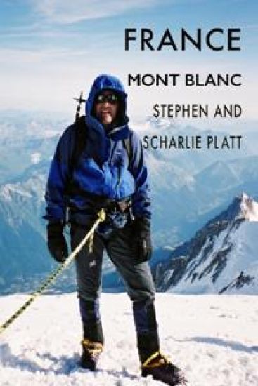
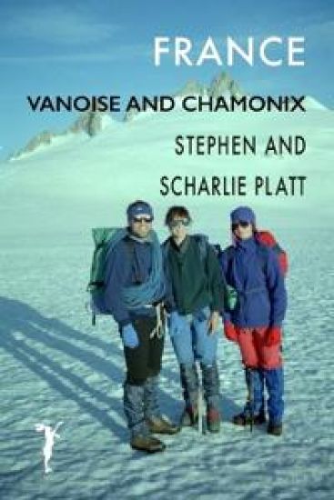
This trip in the early summer of 1994, like other trips we made to the Alps, is a tale of two parts. First we circumnavigated the Vanoise National Park. Created in 1963, it was the first national park in France and is the most bio-diverse with over 5,000 plant species. It borders the Gran Paradiso in Italy and together they form one of the largest protected areas in Europe. We did the six-day hike with Val, a friend from Sheffield and had the alpine flower meadows virtually to ourselves, seeing few other people. The path follows part of the famous Via Alpina, the GR5, that runs from Geneva to Nice, and sections of the GR55. It crosses a number of high passes and most of the path is over 2,500 metres. There was still plenty of snow and we had to watch our step in places. We stayed in refuges or camped near them because wild camping was forbidden in the park. Tony, a friend from Cambridge, joined us for the second week in Chamonix, where we had intended to climb Mont Blanc. In the event, our party of four lacked the experience to tackle the crowning summit and we contented ourselves with three easy routes - the Aiguilles du Tour, Petit Verte and Belv d re. These mixed routes of rock and snow were all delightful, accessible and safe, and the weather was perfect all week. Apart from nights in the Refuges Trient and Lac Blanc, we camped in Frasserands.
Corsica Mare e Monte and Sardinia

Corsica Mare e Monte and Sardinia

Stephen Platt

Leveret Publishing
2024
nidottu
The Mare e Monte Nord traverses Corsica from sea to sea. It's 76 miles long (123km), involves over 6500 metres of ascent. I took me 9 days. Sardinia lies only 7 miles south of Corsica across the Strait of Bonifacio. Although Corsica is French and Sardinia is Italian, they share many characteristics. Geologically and culturally the islands are very similar. Their history, ethnic base, and cuisine are similar. Both have a deep-rooted connection to the sea and both are mountainous. Both have gorgeous magnificent beaches and unspoilt nature. There are some differences. In area, Sardinia is nearly three times larger than Corsica and has a five times bigger population. Corsica has a more continuous mountain chain that gives rise to the GR20 and the other long-distance walks, including the Mare e Monte. Sardinia has fewer recognised long-distance footpaths. The Mare e Monte is unspoilt and much less frequented than the more famous GR20. Much of the way is forested and one is assailed by the scent of herbs and plants. The walk is very up and down. Six of the ten git s are in villages at or near the coast and to get to the next one, you have to climb over ridges and high passes. This means that each day you climb an average of over 700 metres. Most of the way is along ancient transhumance paths for the seasonal movement of livestock and provided the main links between settlements. Sardinia has a rich archaeological history and a vast mountainous interior and it would have been good to have spent longer exploring. But the plan was to have a rest and a pleasant break after the long walk. The Mare e Monte Nord is most worthwhile. It is peaceful, dramatic, varied and interesting. The accommodation is excellent and one gets to enjoy both the crystal clear waters and sandy bays of the coast and the demanding ridges and gorges of the interior.
Corsica Mare a Mare Nord

Corsica Mare a Mare Nord

Stephen Platt

Leveret Publishing
2023
pokkari
The Mare a Mare Nord traverses Corsica from sea to sea. It's nearly 100 miles long (152 km), involves nearly 7000 metres of ascent and descent and took me 11 days. I sailed to Ajaccio, the capital of Corsica, on the west coast, and the walk climbed thickly wooded valleys before crossing the GR20 and the mountainous backbone of Corsica at the Col de Vergio. From Corte, the town in the middle of the island, the path follows mule tracks that link isolated hilltop villages all the way to the east coast at Moriani. Geology and altitude give character to different parts of the walk. You pass through forests of huge sweet chestnuts, tall Laricio pine and beech and follow clear mountain streams past tumbling cascades. The path traverses rugged mountain ridges, ancient stone mule tracks and sunken lanes. The walk is a time travel to a different age. Quiet sleepy villages where the faded signs suggest a busier more prosperous era. Corsica is like an unspoilt wild garden, a walker's paradise, the way carpeted in wildflowers with the scent of herbs and flowers and the constant song of birds. The walk starts and finishes with sandy beaches at the two largest towns in Corsica - Ajaccio and Bastia. The accommodation in Gites and hotels is warm and comfortable and the food excellent. The Mare a Mare Nord is not as hard, dramatic, or as 'good' as the GR20. But what it has that the GR20 doesn't is peace and tranquility; there are just too many doing the immensely popular GR20.
Offa's Dyke

Offa's Dyke

Stephen Platt

Leveret Publishing
2022
pokkari
Offa's Dyke runs along the border between England and Wales. I walked from south to north, from Chepstow to Prestatyn, It took me 12 days. The Path was opened in 1971 by Sir John Hunt, leader of the 1952 Everest Expedition. For over a third of its 177 miles it closely follows the earthworks of Offa's Dyke. It falls into 5 stages, all different and equally interesting and challenging. It begins by following the course of the River Wye from its mouth in the Severn Estuary past lush water meadows and limestone cliffs as far as Monmouth. It then crosses farming country to reach the Black Mountains and the long ridgeway to Hay, where the bend in the Wye is joined again, before embarking on one of the tougher sections, the Shropshire Hills, where the Dyke is at its most evident. The Severn floodplain provides a flat respite of canal towpaths and river banks until the land rises again at Llanymynech and the finale of the Eglwyseg Mountain north of Llangollen and the Clwydian Range from Llandegla to Prestatyn In June, Offa's Dyke is a joyous river of bird song, a green abundance of meadows and magnificant, ancient, oak, ash and lime trees in new leaf. Walking, you sense the generations that have settled, farmed and fought over this land and how places harbour the memories of the people that lived and died here. There is little tarmaced road and most of the way is along tracks and grassy paths. None of it is demanding, but for me it was a challenge, not least because I contracted Covid at the start of the trip. Some days were long and tiring but I enjoyed every bit and highly recommend it.
Coast to Coast

Coast to Coast

Stephen Platt

Leveret Publishing
2021
pokkari
The Coast to Coast was devised by Alfred Wainright and first described in his guide published in 1973. He describes the route in 12 stages; it took me 13 days. I measured it as about 187 miles long (300 km). It traverses three national parks - the Lake District, the Yorkshire Dales and the North York Moors. The walk is extremely varied passing from the dramatic granite pikes and becks of the Lake District to the fascinating Westmorland limestone pavement. Perhaps the most delightful section is that of the Yorkshire Dales from Kirkby Stephen, over Nine Standards and then along the Swale from Keld to Reeth. The C2C starts with a coastal walk along the sandstone cliffs of St Bees Head and finishes satisfyingly with a similar stretch of the Cleveland Way along the shale and mudstone cliffs from Hawkster to Robin Hoods Bay. The idea of a route from the Irish to the North Sea is beguiling and Wainwright cleverly used parts of bridleways and ancient tracks to link the three national parks but there is too much road and the route feels contrived. I'm glad I did it, however, and enjoyed much of it, apart from the tedious stretch from Richmond to Ingleby Arncliffe across the Vale of Mowbray. Looking back, I most enjoyed the Lakes, despite the rain and storms because I know them so well. And I enjoyed the easy day from Keld to Reeth with Scharlie and Bridget, not least because of their obvious pleasure in the landscape and flora
Pennine Way

Pennine Way

Stephen Platt

Leveret Publishing
2020
pokkari
The Pennine Way is a tough old walk. It's about 270 miles long (435 km), was the first National trail in England and is one of the most famous long-distance walks. I did it a couple of weeks before I should have, during the Covid pandemic of 2020 when the guidelines encouraged outdoor exercise but advised against overnight stays away from home. There was no accommodation or catering en-route and few shops open. I arranged two poste-restante food drops at post offices in Alston and Hawes at approximately one-third and two-thirds of the way. That meant I had to wild camp and carry food for a week. Lockdown during the Covid pandemic was a great time to do the Pennine Way. No one else was on the walk. In fact hardly anyone had done it for months and nature had reclaimed the way and at times the path was almost indistinct. The guidelines that everyone should stay at home meant that the villages and settlements I passed through were deserted. It was like a sci-fi movie when everyone has disappeared. When I got back people asked me, what was the best bit. The problem is that so much happens in the 17 days of a walk like this, so much that is singular and arresting. But with the repetition of walking each day over similar ground it becomes difficult for the mind to encompass and remember. Alfred Wainright, who devised the walk in 1938, said he wrote his 'pictorial companion' for himself, so he could relive the walk back in the comfort of home. In part that's what motivated me. But I also needed to make sense of what I'd done, to map it out, and to fit the parts together as a whole.
Terra Firma

Terra Firma

Stephen Platt

Leveret Publishing
2018
pokkari
Terra Firma - very large, about which nothing is known", was how Columbus described the mainland of South America. David finds himself on anything but firm ground when he arrives in Venezuela to work for Jordi's uncle Manuel, the Minister of Planning. Jordi's exotic family befriend him - the uncles who chased out the last dictator, the grandfather, too old for deep-sea fishing but still chasing young women at ninety. He finds cliffs to rock climb in the vast coastal range and the empty interior. At the Ministry he meets Chelo, who takes him to see a fortune-telling witch when they should be working. And he discovers that the site of the new town he is helping plan is on an earthquake fault and that his boss owns the land.
Terra Firma

Terra Firma

Stephen Platt

Leveret Publishing
2018
sidottu
Terra Firma - very large, about which nothing is known", was how Columbus described the mainland of South America. David finds himself on anything but firm ground when he arrives in Venezuela to work for Jordi's uncle Manuel, the Minister of Planning. Jordi's exotic family befriend him - the uncles who chased out the last dictator, the grandfather, too old for deep-sea fishing but still chasing young women at ninety. He finds cliffs to rock climb in the vast coastal range and the empty interior. At the Ministry he meets Chelo, who takes him to see a fortune-telling witch when they should be working. And he discovers that the site of the new town he is helping plan is on an earthquake fault and that his boss, Manuel, owns the land.
Italy

Italy

Stephen Platt; Scharlie Platt

Leveret Publishing
2018
nidottu
In the summer of 2004 we went climbing with Dimitri in the Valle Garrafano in the Apuane Alps, a limestone area famous for its Carrara marble. Dimitri had been a tenant of ours in Cambridge when he had a sabbatical working in the University Library. We returned the following summer and were whisked off again to the rocky valleys of Italy's far northwest. We climbed in the Valle Maira and Valle Gesso in the Maritime Alps, Then we drove further north to the Valle dell'Orco in the Graian Alps near the Parco Gran Paradiso. The rock was superb and we did some great routes following our 'Pied Piper' Dimitri.
Vietnam

Vietnam

Stephen Platt

Leveret Publishing
2018
pokkari
went to Vietnam at Vietnam at very short notice to do a job for the World Bank about housing reconstruction after Typhoon Damrey in Novemeber 2017. Others on the team were reporting on transport, irrigation, agriculture, fisheries and economic development. Unfortunately I pulled a calf muscle at dawn on day one running along Nha Trang beach, as shown in the photo, so I didn't see as much of Vietnam as I would have liked. Nevertheless I did go north up the coast and inland to the highlands to see ieffect of storm and progress in recovery. I loved Vietnam. I liked the food, the way the country is developing and the confidence and directness of the people. I wish I could have stayed a month and seen more.
Colombia

Colombia

Stephen Platt

Leveret Publishing
2018
nidottu
I first met Maria Ximena when she talked about Cazuca, a barrio to the south west of Bogota and I visited Colombia three times. Working with young architects from the Universidad Piloto and a Women's Foundation we devised plans to improve the neighbourhood. I also describe visits to Cartagena, Santa Marta, Valledupar and the Tayrona National Park where I met and talked to Kogi Indians.
Thailand

Thailand

Stephen Platt

Leveret Publishing
2018
nidottu
An account of a trip to Thailand to test using satellite imagery to monitor long-term disaster recovery. We had two or three days in the hot and steamy concrete jungle of Bangkok and then spent a week in Ban Nam Khem, a fishing village on the west coast, that had been badly damaged by the tsunami. We had a day off and visited the fabulous `James Bond' island in Phnag Nga Bay Phuket where Roger Moore fought Scaramanga played by Christopher Lee in `Man with the Golden Gun'.
Pakistan

Pakistan

Stephen Platt

Leveret Publishing
2017
nidottu
This is an account of a trip with Emily So of Cambridge University in 2006 to the areas affected by the Pakistan earthquake of 8 October 2005. The aim of for Emily was to conduct a survey of survivors of the earthquake about their injuries as part of her PhD. My aim was to shed light on the factors affecting long-term recovery after major disasters. We interviewed people in Islamabad responsible for coordinating relief and reconstruction and visited the areas affected by the earthquake. We also drove up the beautiful Kaghan Valley as far as we were able. Understanding some of the issues faced by survivors of the earthquake was a powerful experience for us both and we were treated with the warmest hospitality and generosity by everyone we met in Pakistan