Kirjojen hintavertailu. Mukana 12 136 506 kirjaa ja 12 kauppaa.

Kirjailija

Terry Marsh

Kirjat ja teokset yhdessä paikassa: 30 kirjaa, julkaisuja vuosilta 2006-2026, suosituimpien joukossa The Coast to Coast Path Trail Map. Vertaile teosten hintoja ja tarkista saatavuus suomalaisista kirjakaupoista.

30 kirjaa

Kirjojen julkaisuhaarukka 2006-2026.

The Coast to Coast Path Trail Map

The Coast to Coast Path Trail Map

Terry Marsh

CICERONE PRESS
2026
nidottu
A booklet of all the mapping needed to complete the Coast to Coast Path National Trail, originally conceived by Alfred Wainwright. Suited to experienced walkers, the 317km (197 mile) C2C passes through the Lake District, Yorkshire Dales and North York Moors to link St Bees on the west coast with Robin Hood’s Bay on the east. The full route line is shown on 1:25,000 OS maps The map booklet can be used to walk the trail in either direction Sized to easily fit in a jacket pocket The relevant extract from the OS Explorer map legend is included An accompanying Cicerone guidebook – Walking the Coast to Coast Path is also available, which includes a copy of this map booklet
15 Short Walks on the Isle of Skye

15 Short Walks on the Isle of Skye

Terry Marsh

CICERONE PRESS
2025
nidottu
Would you like to explore the best of the Isle of Skye? This guidebook covers 15 of the best short walks in the area (all under three hours), including the Old Man of Storr, the Quiraing pinnacles, Rubha Hunish and the Fairy Pools. Why choose this guidebook? Easy to moderate walks suitable for almost everyoneShort climbs but no challenging terrainNumbered points which tie OS maps to clear route descriptionFacilities, parking and highlights for every routeRoute Summary Table to help you choose your walk Cicerone’s Short Walks guidebooks contain everything you need to get outdoors and discover the best of an area. The routes are perfect if you’re new to walking or looking for something you can enjoy with the whole family. Let the adventures begin!
Exploring Lake District Dales

Exploring Lake District Dales

Terry Marsh

BLOOMSBURY PUBLISHING PLC
2025
nidottu
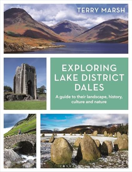
Explore the beauty of the Lake District dales with this enchanting and absorbing guide.Crisp and sharp, fascinating throughout, [this book] is an outstanding journey through the Lake District. - Bill Birkett, Author, Mountaineer and PhotographerThe Lake District has over 100 dales, many of them tranquil enclaves far from the hectic comings and goings of daily Lakeland life. Yet beyond the main river arteries, most dales remain little-known; some see more sheep and deer than humans. Even locals would be hard pressed to pinpoint some with certainty.Ticking your way through a list of Lake District summits is easy; they stick up and are easily accounted for. Less so the dales. Where, for example, is Blengdale, or Miterdale, seldom-visited Woundale, Fusedale, Moasdale and Pasture Bottom?In Exploring Lake District Dales, Terry Marsh champions the cause of the dales. Diving into their geology, geography, history, culture, folklore and matters of curious and touristic interest, this book reveals the beauty and appeal of dales, great and small.Among captivating text and stunning photography, Exploring Lake District Dales also provides you with essential visitor information such as transport links, the most inspiring visitor attractions and sights, unmissable restaurants and great places to stay, making this book the complete package for all Lake District admirers.
Walking on Mull, Coll and Tiree

Walking on Mull, Coll and Tiree

Terry Marsh

CICERONE PRESS
2025
nidottu
A guidebook to 50-day walks on the Isles of Mull, Coll and Tiree. From short circuits and linear coastal and glen walks to demanding mountain routes, there is something for walkers of all fitness levels and experience on this Inner Hebridean island. The walks range in length from 2-19km (1-12 miles) and cover Mull and the neighbouring islands of Coll, Tiree, Iona, Ulva, Gometra and Erraid. 1:50,000 OS maps included for each walkGPX files available to downloadDetailed information on accommodation and ferry transportEasy access from Tobermory and CraignureHighlights include an ascent of Ben More
Exploring Scotland's Islands

Exploring Scotland's Islands

Terry Marsh

BLOOMSBURY PUBLISHING PLC
2024
nidottu
Explore the enchanting islands of Scotland with this absorbing and beautiful guide.Around the coast of Scotland there are hundreds of islands, from bare, rugged skerries to lush dominions of history and deep-rooted culture. Each offers a unique haven to explore, whether you enjoy sparkling-white sandy beaches, miles of untouched land beneath your feet, nature-spotting among otters, puffins, seals and more, sampling the finest whisky and cheeses, or learning more about Scotland’s history. Exploring Scotland’s Islands describes the main island groups in all their moods, and focuses on what gives these islands such magical and lasting appeal. This book is a glorious celebration in words, maps, illustrations and photographs of some of the most superb scenery in Scotland. Discover why these unique isles draw those lucky enough to find them back to visit whenever they can. Among captivating descriptive text and beautiful photography, Exploring Scotland’s Islands also provides the reader with essential visitor information such as transport links, the most inspiring visitor attractions and sights to see, cafés and restaurants not to be missed, and where you can stay to make your visits all the more special.
15 Short Walks on the Isle of Mull

15 Short Walks on the Isle of Mull

Terry Marsh

CICERONE PRESS
2024
nidottu
Would you like to explore the best of the Isle of Mull? This guidebook covers 15 of the best short walks in the area (between 1.5 and 10.5km), including Tobermory, Aros Park, Glengorm Castle, Treshnish, and the beaches of Langamull, Kilvickeon and Tireragan. Why choose this guidebook? Walks under three hours, plus one challenge routeEasy to follow with clear route descriptionsFacilities, parking and highlights for every routeNo specialist gear needed, walk all year roundOrdnance Survey mapping Cicerone’s Short Walks guidebooks contain everything you need to get outdoors and discover the best of an area. The routes are perfect if you’re new to walking or looking for something you can enjoy with the whole family. Let the adventures begin!
The Isle of Skye

The Isle of Skye

Terry Marsh

CICERONE PRESS
2024
nidottu
A guidebook to 87 walks and scrambles on the Isle of Skye. Covering the largest island in the Inner Hebrides, the walks are suitable for most walkers, with shorter routes alongside plenty of more challenging, full-day hikes. The routes range from 2 to 23km (1–15 miles) and can be combined to create longer days out. Eight routes include scrambles, which are clearly indicated in the book. 1:50,000 OS maps are included for each routeDetailed information on facilities, accommodation, history and geologyEasy access from Portree and BroadfordHighlights include routes in the Cuillin and Munro ascents
Walking the Dales Way

Walking the Dales Way

Terry Marsh

CICERONE PRESS
2024
pokkari
Guidebook to walking the Dales Way. This picturesque 79 mile route through the Yorkshire Dales between Ilkley and Bowness-on-Windermere is one of the most gentle long-distance walks in Britain. The route is described in both directions, passing through Wharfedale, Dentdale and the eastern fringe of the Lake District. With 1:25K OS map booklet.
West Highland Way Map Booklet

West Highland Way Map Booklet

Terry Marsh

CICERONE PRESS
2024
nidottu
A booklet of all the mapping needed to walk the West Highland Way, one of Scotland’s Great Trails. Covering 155km (97 miles) from Milngavie to Fort William, the route is suitable for walkers of most abilities and takes around a week to complete. The full route line is shown on 1:25,000 OS maps The map booklet can be used to walk the trail in either direction Sized to easily fit in a jacket pocketThe relevant extract from the OS Explorer map legend is included An accompanying Cicerone guidebook – Walking the West Highland Way is also available, which includes a copy of this map booklet
The West Highland Way

The West Highland Way

Terry Marsh

CICERONE PRESS
2024
nidottu
A guidebook to walking the West Highland Way, one of Scotland’s Great Trails. Covering 156km (96 miles) from Milngavie to Fort William, the route is suitable for walkers of most abilities and takes around a week to complete. The trail is described from south to north in 7 stages of between 14 and 33km (9–20 miles). Contains step-by-step description of the route alongside 1:100,000 maps GPX files available to downloadIncludes a separate map booklet containing OS 1:25,000 mapping with the route line A handy trek planner highlights the availability of facilities and public transport along the route Accommodation table provided
Dales Way Map Booklet

Dales Way Map Booklet

Terry Marsh

CICERONE PRESS
2023
pokkari
Map of the 79 mile (127km) Dales Way through the Yorkshire Dales between Ilkley and Bowness-on-Windermere. This booklet is included with the Cicerone guidebook and shows the full route on OS 1:25K maps. One of the most gentle multi-day walks in Britain, it passes through Grassington, Kettlewell, Dent, Sedbergh and Staveley.
The West Highland Way

The West Highland Way

Terry Marsh

CICERONE PRESS
2023
nidottu
A guidebook to Scotland's West Highland Way, a 95-mile walk from Milngavie near Glasgow to Fort William, passing Loch Lomond, crossing Rannoch Moor and finishing in the shadow of Britain's highest mountain. The walk, which takes roughly one week to complete, is described in seven stages, with each stage ranging from 8 to 20 miles. The guide details the 'classic' south-north direction but also provides a summary description for those wanting to walk the route in the opposite direction. The guidebook, which features step-by-step route descriptions, 1:100K mapping, handy practical information as well as notes on the region's history, culture and geography, is accompanied by a separate, pocket-sized 1:25K OS map booklet, providing all the mapping you need to walk the route. Passing from the lowlands to the highlands, the West Highland Way, which is one of Scotland's Great Trails, showcases the splendour of glens flanked by great mountains, majestic moorland and sprawling farmland. It is the perfect adventure for distance walkers keen to discover the wild beauty of western Scotland.
Walking on the Isle of Man

Walking on the Isle of Man

Terry Marsh

CICERONE PRESS
2023
nidottu
A guidebook to 40 walks exploring the Isle of Man. Covering the whole island, including the mountains, coast and National Glens, there are walks to suit all abilities, from shorter low-level routes to longer and more demanding excursions. With many walks accessible by public transport, the routes range from 2 to 23km (1–14 miles) and take in waterfalls, historical sites of interest and the island’s highest mountains, Snaefell and North and South Barrule. 1:50,000 OS maps, reproduced at 1:40,000, included for each walkSized to easily fit in a jacket pocketNotes on refreshments and parkingInformation on local geology, history, culture, plants and wildlifeBrief summaries of five longer routes, including the 153km (95 mile) Raad ny Foillan (Isle of Man Coast Path, covered in a separate Cicerone guide)
Walking the Severn Way

Walking the Severn Way

Terry Marsh

CICERONE PRESS
2023
pokkari
Guidebook to walking the Severn Way, a 215 mile (344km) walk through the Welsh borders. Beginning near the source of the River Severn in Powys, mid-Wales, and finishing in Bristol, the history-rich route is described over 22 stages (ranging from 3 to 14 miles), passing through the counties of Powys, Shropshire, Worcestershire and Gloucestershire.
Coast to Coast Map Booklet

Coast to Coast Map Booklet

Terry Marsh

Cicerone Press
2023
pokkari
Map of the 190 miles (300km) Coast to Coast Walk, between St Bees Head in Cumbria and Robin Hood's Bay in Yorkshire. This booklet is included with the Cicerone guidebook to the trail, and shows the full route on OS 1:25,000 maps. This popular long-distance route typically takes a fortnight to walk.
The Coast to Coast Walk

The Coast to Coast Walk

Terry Marsh

CICERONE PRESS
2023
nidottu
A guidebook to walking the Coast to Coast Path National Trail, originally conceived by Alfred Wainwright. Suited to experienced walkers, the 302km (188 mile) C2C passes through the Lake District, Yorkshire Dales and North York Moors to link St Bees on the west coast with Robin Hood’s Bay on the east. The route is described from west to east, with a summary for hikers travelling in the opposite direction. It is presented in 13 stages of between 17 and 33km – perfect for a fortnight’s holiday – although longer itineraries are also suggested. Contains step-by-step description of the route alongside 1:100,000 maps and elevation profilesIncludes a separate map booklet containing OS 1:25,000 mapping and route lineRoute summary table and trek planner showing the distribution of facilties and public transport along the route Accommodation listings
Walking in the Forest of Bowland and Pendle
A guidebook to 40 diverse circular day walks suitable for walkers with navigational skills. The Forest of Bowland and Pendle are two of north west England's upland AONBs, perfect for walkers who enjoy exploring rough hilly, sometimes pathless terrain. The routes include Ward's Stone, Pendle Hill, Longridge Fell and Fair Snape Fell.
Walking on the West Pennine Moors

Walking on the West Pennine Moors

Terry Marsh

Cicerone Press
2022
pokkari
This guidebook describes 30 walks on the West Pennine Moors, around Blackburn, Darwen, Chorley and Bolton, home to some of the most inspiring and exhilarating walking country. The walks range from short, easy rambles to more challenging hikes covering a variety of terrain, all of it easily accessible for day walking.
Health and Social Services in Puerto Rico Before and After Hurricane Maria

Health and Social Services in Puerto Rico Before and After Hurricane Maria

Anita Chandra; Terry Marsh; Jaime Madrigano; Molly M Simmons; Mahshid Abir; Edward W Chan; Jamie Ryan; Nupur Nanda; Michelle D Ziegler; Christopher Nelson

RAND
2020
nidottu
Hurricane Maria magnified Puerto Rico's fragile system for delivering social, behavioral, and environmental health services, which were evidenced by chronic disease burdens, demographic transitions, and unmet health needs. The recovery plan outlines action strategies for building a robust health infrastructure, strengthening the health care workforce, expanding social service capacity, and investing in healthy communities.