Kirjailija
National Geographic Maps
Kirjat ja teokset yhdessä paikassa: 328 kirjaa, julkaisuja vuosilta 2009-2026, suosituimpien joukossa Virginia. Vertaile teosten hintoja ja tarkista saatavuus suomalaisista kirjakaupoista.
328 kirjaa
Kirjojen julkaisuhaarukka 2009-2026.
While GPS is handy for navigating unfamiliar cities, there is nothing better than a printed map for simplicity, perspective and fun on road trips. National Geographic's State Guide Maps are the perfect combination of detailed map and travel guide. Each map contains scenic drives, parks and recreation maps, as well as insets of cities and useful information on local attractions and events. The maps are printed on durable, waterproof, tear-resistant material that is lightweight and easily folded to fit in your pocket.
National Geographic's Trails Illustrated Maps are the most detailed and up-to-date topographic recreation maps available for US National Parks, National Forests and other popular outdoor recreation areas. A necessity for exploring the outdoors, each map is printed on waterproof, tear-resistant material. They also contain key safety and contact information, GPS and compass coordinates, Leave No Trace ethical guidelines and hundreds of points-of-interest, including scenic viewpoints, campgrounds, boat launches, swimming areas, marine sanctuaries and wildlife refuges.
The newly redesigned National Geographic DestinationMaps series strikes the perfect balance between map and guidebook, and they are the ideal resource for touring culturally and geographically unique areas. All maps are double-sided with beautiful photos and detailed travel information, including comprehensive road networks, local information and natural, historical and cultural places of interest. The maps are printed on durable, waterproof, tear-resistant material that is lightweight and easily folded to fit in your pocket.
AdventureMaps provide global travellers with the perfect combination of detail and perspective, highlighting hundreds of points of interest and the diverse and unique destinations within the country. Each map is printed on durable synthetic paper, making them waterproof and tear-resistant. They also include the locations of cities and towns with a user-friendly index, plus a clearly marked road network complete with distances and designations for major highways, main roads and tracks and trails for those seeking to explore more remote regions.
AdventureMaps provide global travellers with the perfect combination of detail and perspective. The Chile map details from the northern Peruvian border south to Concepcion, including Santiago, La Serena, Atacama, Arica, and Chanaral, on to Cape Horn at the southern most tip, rich with National Parks. Notable places included are Punta Arenas, Concepcion, Puerto Montt, Tierra del Fuego, and Coihaique. Additional inset maps provide detail for Easter Island, Archipelago Juan Fernandez, and the islands of San Felix and San Ambrosio.
National Geographic World Wall Map - Explorer Executive - Laminated (Poster Size: 36 X 24 In)
National Geographic Maps
2026
kartta
National Geographic World Wall Map - Explorer Executive (Poster Size: 36 X 24 In)
National Geographic Maps
2026
kartta
Pacific Crest Trail Overview and Planning Map
National Geographic Maps
2026
muu
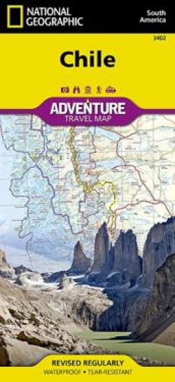
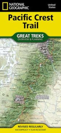
- Waterproof - Tear-Resistant - Topographic Map Discover the Pacific Crest Trail (P.C.T.) with National Geographic The P.C.T. spans 2,650 miles from the Canadian border, through Washington, Oregon, and California to the southern terminus at the Mexican border. The famous trail crosses some of the most wild and scenic landscapes of the western U.S., including six national parks, 25 national forests, 48 wilderness areas, the volcanic Cascade Range of the Pacific Northwest, the snowcapped Sierra Nevada, and the Mojave and Sonoran deserts. The National Geographic Pacific Crest Trail Overview and Planning Map is an essential companion for every hiker. Designed for both first-time trekkers and seasoned adventurers, this beautifully detailed map and its accompanying infographics make planning easier, smarter, and more inspiring. The map displays the entire length of the P.C.T., highlighting nearby towns, roads, section markers, and key waypoints. A comprehensive trail chart provides cumulative mileage from both termini, section distances, average slope, elevation gain and loss, and the highest and lowest points along each segment. You'll also find practical details such as shelters, parking areas, river crossings, campsites, and nearby airports--everything you need to plan with confidence. For extended journeys, a convenient resupply table lists services and food options along the trail, making it simple to organize a multi-day, weeklong, or full thru-hike adventure. Whether you're dreaming, preparing, or already lacing up your boots, the National Geographic Pacific Crest Trail Overview and Planning Map is the perfect tool to turn your P.C.T. plans into reality. Every Great Treks map is printed on "Backcountry Tough" waterproof, tear-resistant paper. A full Lat/Long grid is printed on the map to aid with GPS navigation. Every map purchase helps support the National Geographic Society, an impact driven, nonprofit organization with global reach that uses the power of science, exploration, education, and storytelling to illuminate and protect the wonder of our world. Sheet Size = 25.5" x 37.75" Folded Size = 4.25" x 9.25"
- Sheet Size = 25.5" x 37.75" Folded Size = 4.25" x 9.25"
The World Reference Map (folded)
National Geographic Maps
2024
kartta, viikattu
Expertly researched and designed, National Geographic's World with Flags and Facts Map is the authoritative map of the world by which other reference maps are measured. The folded world map is designed for travel and durability. Product Features: -Signature Classic style map with bright, easy to read color palette with blue oceans and colorful borders -Background shows mountain ranges and valleys in subtle shaded relief with mountain ranges labeled -Major water bodies including rivers, lakes, glaciers, oceans, seas, gulfs, bays, straits, and bathymetry -Clearly defined international boundaries, cities, islands, airports, and physical features -Thousands of place names carefully and artfully placed to maintain legibility in heavily populated areas -Up-to-date international boundaries and territorial control reflect de facto status on the ground -Meticulously researched using multiple authoritative sources including the U.N., U.S. Board on Geographic Names, and policies of individual governments. -Accurate place names use a combination of conventional English names, official national names, and standard transliterations for non-Latin alphabets. -Drawn in Winkel Tripel projection with distortions minimized unlike other World maps (e.g. Greenland is shown the same size as Argentina, not South America) -Corner inset maps feature vegetation, land use, population density, and north and south polar regions -National facts and flags with each country's area, population, capital city, GDP per capita, and flag The map is printed in the USA on durable waterproof, tear-resistant synthetic paper to withstand repeated folding.
National Geographic's Trails Illustrated Maps are the most detailed and up-to-date topographic recreation maps available for US National Parks, National Forests and other popular outdoor recreation areas. A necessity for exploring the outdoors, each map is printed on waterproof, tear-resistant material. They also contain key safety and contact information, GPS and compass coordinates, Leave No Trace ethical guidelines and hundreds of points-of-interest, including scenic viewpoints, campgrounds, boat launches, swimming areas, marine sanctuaries and wildlife refuges.
Our 2nd edition Texas Road & Recreation Atlas is now available! It's bigger and better, featuring stronger covers & binding and a new map projection that widens the perspective on our Landscape Maps, resulting in 40 additional pages. The vast openness of Texas is the source of everything that makes it unique. No other publication can display this dense, expansive landscape and its recreation potential with more precision than Benchmark's Texas Road & Recreation Atlas. The field-checked Landscape Maps reveal back-roads & land-forms with amazing realism and detail, clearly showing how the state's network of roads and local recreation landmarks fit into the countryside. A Recreation Guide provides regional maps and lists a variety of outdoor activities. Arranged by category, it is the ideal planning tool for any adventure, from a simple day-trip to an extended exploration. Benchmark field-checkers, cartographers, and editors have been working to make the Texas Road & Recreation Atlas the most accurate, comprehensive, and reliable map product ever published for The Lone Star State. Landscape Maps(TM) Land cover & vegetation base layer over shaded relief portraying the terrain Highway & back-road detail, extensively field-checked Many historical markers located & labeled Public Lands and Access Points Page to page map overlap, superb design Recreation Guide Regional maps with public land detail, recreation points of interest, point-to-point mileages, hunting units, and more Categorized listings and map features include: Parks, Monuments, & Wildlife Areas, Camping, Fishing & Boating Access, Museums & Historic Sites, and more. 200 Pages, Spiral-bound; 2nd Edition 2022. ISBN 9781734315080 Map Scales: Landscape Maps 1:253,400 (1inch=4 miles) Recreation Maps 1:1,267,200 (1inch=20 miles)
North Fork Range, Deadwood River Map
National Geographic Maps
2022
kartta, viikattu
Waterproof, Tear-Resistant, Topographic Map. Great Basin National Park, in eastern Nevada, is a great example of the rich biodiversity found throughout the expansive Great Basin region. From the sage-covered foothills to the 13,063-foot summit of Wheeler Peak, this single park covers multiple life zones, including desert shrub, pinon-juniper forests, and alpine environments. Some of the oldest living things on Earth, the gnarled bristlecone pines, live just below tree line. The park's remote location in eastern Nevada ensures some of the darkest night skies in the United States. National Geographic's Trails Illustrated map of this unique park offers outdoors enthusiasts a valuable tool for exploring the park's natural beauty and solitude. Expertly researched and created in partnership with Great Basin National Park, this map features trail networks in the park along with key points of interest including: Wheeler Peak, Lehman Caves, bristlecone pine groves, and the Snake Range. The map
Wind River Range North Map [pinedale, Dubois]
National Geographic Maps
2021
kartta, viikattu
Waterproof, Tear-Resistant, Topographic Map. The Wind River Range of northwest Wyoming encompasses an area of more than 3,500 square miles. Locally known as just 'The Winds', the range contains a unique combination of jagged granite rock, alpine forest, open meadows, over 1,300 named lakes, and the largest glacier in the American Rockies. Recreation opportunities are distributed across the landscape with hiking, camping, fishing, and snowmobiling to list just a few. The map is centered on the northern section of the Wind River Range. The Fitzpatrick Wilderness and a large section Bridger Wilderness are clearly shown with the Continental Divide running through the middle of the map. The glaciers and countless lakes make this map a must-have for visitors entering from Pinedale or Dubois. The Continental Divide Trail transects this area on its way from Mexico to Canada. The map also includes Gannett Peak, the highest point in Wyoming. The Wyoming State Department of Fish and Game provide
Wind River Range South Map [lander, Cirque Of The Towers]
National Geographic Maps
2021
kartta, viikattu
Waterproof, Tear-Resistant, Topographic Map. The Wind River Range of northwest Wyoming encompasses an area of more than 3,500 square miles. Locally known as just 'The Winds', the range contains a unique combination of jagged granite rock, alpine forest, open meadows, over 1,300 named lakes, and the largest glacier in the American Rockies. Recreation opportunities are distributed across the landscape with hiking, camping, fishing, climbing and snowmobiling to list just a few. The map is centered on the southern section of the Wind River Range. The Popo Agie Wilderness and a large section Bridger Wilderness are clearly shown with the Continental Divide running through the middle of the map. The glaciers and countless lakes make this map a must-have for visitors entering from Lander. The Continental Divide Trail transects this area on its way from Mexico to Canada. The map also includes Cirque of the Towers, a nearly circular ring of jagged peaks towering over Lonesome Lake. The Wyoming
Benchmark Montana Road & Recreation Atlas, 5th Edition
National Geographic Maps
Benchmark Maps
2021
nidottu
Montana is the crown jewel of the American West. Experience Big Sky Country with our completely new edition of Montana Road & Recreation Atlas. No other map product can better portray Montana's rugged peaks, majestic rivers, and expansive plains. Large-scale Landscape MapsTM reveal landforms with amazing realism and detail, clearly showing the state's vast network of roads, waterways, and recreation landmarks. A 30-page Recreation Guide provides regional maps with public land detail and lists a wide range of outdoor activities. Arranged by category and boasting unequalled insight and detail, it is the ideal tool for planning and - executing - Montana exploration.
Benchmark Nevada Road & Recreation Atlas. Nevada is rich with public lands that are as wild and diverse as the state's reputation. This is the first atlas to corral all of Nevada's marvels and outdoor recreation potential. Careful and thorough field checking and local research assure users the best Nevada outdoor experience possible. Recreation maps show public land ownership and hunting units, with a categorised guide of parks & forests, historic sites, natural wonders, and camping & RV sites. Special metro maps of Las Vegas and Reno, and a dazzling view of Lake Tahoe make this a complete atlas for home planning and road tripping through the Silver State. 7th Edition.
Idaho Road & Recreation Atlas, 6th Edition
National Geographic Maps
2021
nidottu
The new National Geographic Benchmark Recreation Atlases are an ideal recreation resource complete with accurate, detailed topographic maps. They contain a wealth of robust travel information, including campground locations, state park maps, sports and activity destinations, museums, hunting and fishing information, historic sites and even climate details. Every feature is clearly labelled, field-checked and verified, and everything is organised for convenience and intuitive ease-of-use. The books feature a double laminated cover to prevent wear and tear.